File:Nouvelle-France map-fr.svg

原始文件 (SVG文件,尺寸为1,530 × 1,090像素,文件大小:375 KB)
说明
说明
摘要
[编辑]| 描述 |
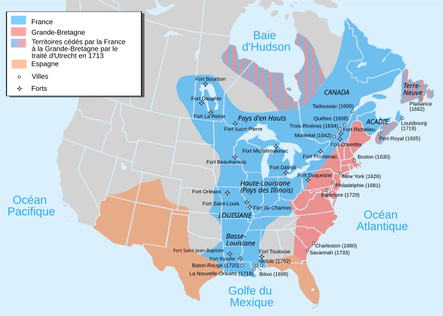
Català: Mapa de la Nova França sobre 1754-1755 English: Map of New France about 1750 using modern political boundaries Español: Mapa de la Nueva Francia cerca de 1750. Français : Carte de la Nouvelle-France vers 1754-1755 Norsk nynorsk: Kart over Ny Frankrike (ca 1754-1755) Русский: Карта Французских колоний в Америке 1750 中文(中国大陆): 1750年左右的新法兰西地图,附现代边界。 العربية : خريطة فرنسا الجديدة حوالي عام 1750 باستخدام الحدود السياسية الحديثة |
||
| 日期 | |||
| 来源 |
travail personnel from Image:Nouvelle-France1750.png 1) Les Villes françaises du Nouveau Monde : des premiers fondateurs aux ingénieurs du roi, XVIe-XVIIIe siècles / sous la direction de Laurent Vidal et Emilie d'Orgeix /Éditeur : Paris : Somogy 1999. 2) Canada-Québec 1534-2000/ Jacques Lacoursière, Jean Provencher et Denis Vaugeois/Éditeur: Sillery (Québec): Septentrion 2000. |
||
| 作者 | Pinpin | ||
| 其他版本 |
File:Nouvelle-France map-fr.svg has 4 translations.
Other related versions:[]
|


|
This SVG file contains embedded text that can be translated into your language, using any capable SVG editor, text editor or the SVG Translate tool. For more information see: About translating SVG files. |
This file is translated using SVG <switch> elements. All translations are stored in the same file! Learn more.
For most Wikipedia projects, you can embed the file normally (without a To translate the text into your language, you can use the SVG Translate tool. Alternatively, you can download the file to your computer, add your translations using whatever software you're familiar with, and re-upload it with the same name. You will find help in Graphics Lab if you're not sure how to do this. |
许可协议
[编辑]

|
已授权您依据自由软件基金会发行的无固定段落及封面封底文字(Invariant Sections, Front-Cover Texts, and Back-Cover Texts)的GNU自由文件许可协议1.2版或任意后续版本的条款,复制、传播和/或修改本文件。该协议的副本请见“GNU Free Documentation License”。 |
- 您可以自由地:
- 共享 – 复制、发行并传播本作品
- 修改 – 改编作品
- 惟须遵守下列条件:
- 署名 – 您必须对作品进行署名,提供授权条款的链接,并说明是否对原始内容进行了更改。您可以用任何合理的方式来署名,但不得以任何方式表明许可人认可您或您的使用。
- 相同方式共享 – 如果您再混合、转换或者基于本作品进行创作,您必须以与原先许可协议相同或相兼容的许可协议分发您贡献的作品。
文件历史
点击某个日期/时间查看对应时刻的文件。
| 日期/时间 | 缩略图 | 大小 | 用户 | 备注 | |
|---|---|---|---|---|---|
| 当前 | 2023年9月18日 (一) 17:12 | | 1,530 × 1,090(375 KB) | JoanSMF(留言 | 贡献) | File uploaded using svgtranslate tool (https://svgtranslate.toolforge.org/). Added translation for ca. |
| 2023年9月18日 (一) 17:09 |  | 1,530 × 1,090(370 KB) | JoanSMF(留言 | 贡献) | File uploaded using svgtranslate tool (https://svgtranslate.toolforge.org/). Added translation for ca. | |
| 2022年12月14日 (三) 19:40 |  | 1,530 × 1,090(366 KB) | Tcr25(留言 | 贡献) | Fort Rosaile in wrong location; add Fort St-Jean-Baptiste | |
| 2021年8月23日 (一) 02:14 |  | 1,530 × 1,090(353 KB) | Praça de Maio(留言 | 贡献) | File uploaded using svgtranslate tool (https://svgtranslate.toolforge.org/). Added translation for tr. | |
| 2021年8月23日 (一) 02:13 |  | 1,530 × 1,090(351 KB) | Praça de Maio(留言 | 贡献) | File uploaded using svgtranslate tool (https://svgtranslate.toolforge.org/). Added translation for tr. | |
| 2020年4月5日 (日) 11:30 |  | 1,530 × 1,090(343 KB) | Les Meloures(留言 | 贡献) | File uploaded using svgtranslate tool (https://tools.wmflabs.org/svgtranslate/). Added translation for lb. | |
| 2020年4月5日 (日) 11:15 |  | 1,530 × 1,090(343 KB) | Les Meloures(留言 | 贡献) | File uploaded using svgtranslate tool (https://tools.wmflabs.org/svgtranslate/). Added translation for lb. | |
| 2020年3月12日 (四) 12:59 |  | 1,530 × 1,090(326 KB) | Gumruch(留言 | 贡献) | Reverted to version as of 11:30, 24 September 2018 (UTC) | |
| 2020年3月12日 (四) 12:58 |  | 1,530 × 1,090(342 KB) | Gumruch(留言 | 贡献) | File uploaded using svgtranslate tool (https://tools.wmflabs.org/svgtranslate/). Added translation for cs. | |
| 2018年9月24日 (一) 11:30 |  | 1,530 × 1,090(326 KB) | GrandCelinien(留言 | 贡献) | Reverted to version as of 22:43, 3 December 2011 (UTC) - La carte est toute floue, ce n'est même plus une vraie SVG. |
您不可以覆盖此文件。
文件用途
以下17个页面使用本文件:
- User:Magog the Ogre/Multilingual legend/2020 April 1-10
- User:Magog the Ogre/Multilingual legend/2020 March 11-20
- User:Magog the Ogre/Multilingual legend/2021 August 21-31
- User:Magog the Ogre/Multilingual legend/2022 December 11-20
- User:Magog the Ogre/Multilingual legend/2023 September 16-20
- File:Neufrankreich.svg
- File:Nouvelle-France1750.jpg
- File:Nouvelle-France1750.png
- File:Nouvelle-France map-ar.svg
- File:Nouvelle-France map-ca.svg
- File:Nouvelle-France map-en.svg
- File:Nouvelle-France map-es.svg
- File:Nouvelle-France map-fr.svg
- File:Nouvelle-France map-he.svg
- File:Nouvelle-France map-ru.svg
- File:Nouvelle-France map-zh-hans.svg
- Template:Other versions/Nouvelle-France map
全域文件用途
以下其他wiki使用此文件:
- ang.wikipedia.org上的用途
- be-tarask.wikipedia.org上的用途
- be.wikipedia.org上的用途
- bg.wikipedia.org上的用途
- ca.wikipedia.org上的用途
- co.wikipedia.org上的用途
- cs.wikipedia.org上的用途
- de.wikipedia.org上的用途
- el.wikipedia.org上的用途
- eo.wikipedia.org上的用途
- fr.wikipedia.org上的用途
- Discussion:Québec/Archive 2
- René-Robert Cavelier de La Salle
- Liste des colonies françaises
- Histoire du Canada
- Pierre André de Suffren
- Traité de Versailles (1783)
- Empire colonial français
- Royaume de France
- Histoire de l'Acadie
- Quelques arpents de neige
- Territoires français du nord
- Guerre de la Conquête
- États-Unis
- Franco-Américains
- Utilisateur:Urban/cartes
- Colonisation française des Amériques
- Utilisateur:Xinpeijin/Aide:Captcha
- Portail:Nouvelle-France/Carte de la Nouvelle-France
- Wikipédia:Atelier graphique/Cartes/Archives/décembre 2007
- Liste des forts de la Nouvelle-France
- Discussion utilisateur:The Ogre
- En canot sur les chemins d'eau du Roi
- Vieilles colonies
- Portail:Nouvelle-France
- Histoire de la Louisiane
- Immigration française à Porto Rico
- Histoire de France
- Ferme d'Occident
- Alliance franco-indienne (Amérique)
- Wikipédia:Atelier graphique/Cartes/Archives/Demandes mises en sommeil/Amériques
- Projet:Nouvelle-France/Brasserie Port-Royal/Archives 8
- Colonisation basque des Amériques
查看此文件的更多全域用途。