File:PghTriState.PNG
Jump to navigation
Jump to search

Size of this preview: 800 × 533 pixels. Other resolutions: 320 × 213 pixels | 640 × 427 pixels | 975 × 650 pixels.
Original file (975 × 650 pixels, file size: 54 KB, MIME type: image/png)
Captions
Captions
Add a one-line explanation of what this file represents
Summary
[edit]

|
This file was moved to Wikimedia Commons from en.wikipedia using a bot script. All source information is still present. It requires review. Additionally, there may be errors in any or all of the information fields; information on this file should not be considered reliable and the file should not be used until it has been reviewed and any needed corrections have been made. Once the review has been completed, this template should be removed. For details about this file, see below. Check now! |
| Description |
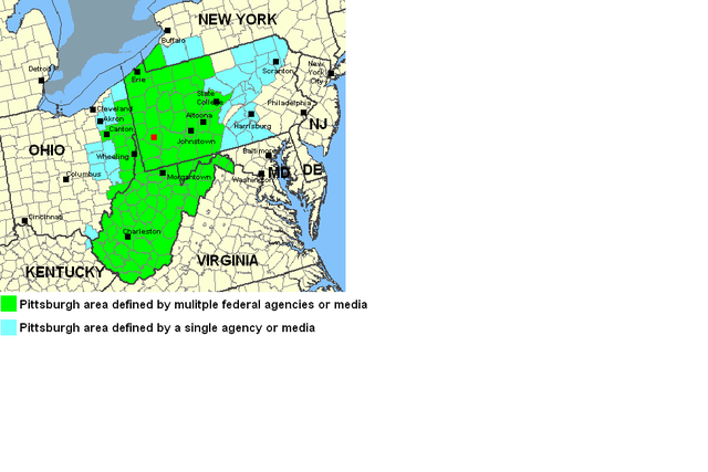
English: This work is from the data provided by National Atlas a federal mapping service. It has been modified by Hholt01 to denote Pittsburgh media or Pittsburgh based federal agencies and the counties either cover. |
| Date | 18 August 2007 (original upload date) |
| Source | Transferred from en.wikipedia |
| Author | Original uploader was Hholt01 at en.wikipedia |
Licensing
[edit]
This map was obtained from an edition of the National Atlas of the United States. Like almost all works of the U.S. federal government, works from the National Atlas are in the public domain in the United States.
Online access: NationalAtlas.gov | 1970 print edition: Library of Congress, Perry-Castañeda Library
|
Original upload log
[edit]
The original description page was here. All following user names refer to en.wikipedia.
- 2007-08-18 06:45 Hholt01 975×650× (55654 bytes) Map is from data at the National Atlas website of the U.S. Government. The place names and county colors were added to the image by Hholt01 to better reflect Pittsburgh regional bounds. ~~~~
- 2007-08-18 06:32 Hholt01 975×650× (55305 bytes) This work is from the data provided by National Atlas a federal mapping service. It has been modified by Hholt01 to denote Pittsburgh media or Pittsburgh based federal agencies and the counties either cover.
File history
Click on a date/time to view the file as it appeared at that time.
| Date/Time | Thumbnail | Dimensions | User | Comment | |
|---|---|---|---|---|---|
| current | 20:52, 12 January 2012 | | 975 × 650 (54 KB) | MGA73bot2 (talk | contribs) | {{BotMoveToCommons|en.wikipedia|year={{subst:CURRENTYEAR}}|month={{subst:CURRENTMONTHNAME}}|day={{subst:CURRENTDAY}}}} {{Information |Description={{en|This work is from the data provided by National Atlas a federal mapping service. It has been modified |
You cannot overwrite this file.
File usage on Commons
There are no pages that use this file.
File usage on other wikis
The following other wikis use this file:
- Usage on en.wikipedia.org