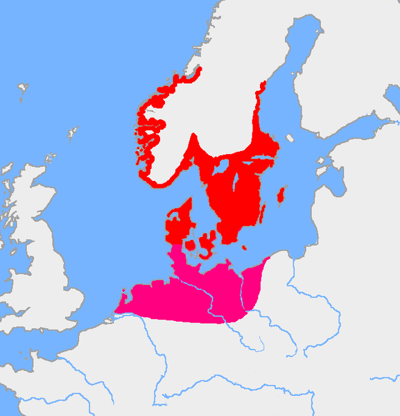
File:Pre-roman iron age (map).PNG
出自Wikimedia Commons
跳至導覽
跳至搜尋

預覽大小:577 × 600 像素。 其他解析度:231 × 240 像素 | 462 × 480 像素 | 657 × 683 像素。
原始檔案 (657 × 683 像素,檔案大小:38 KB,MIME 類型:image/png)
檔案資訊
結構化資料
說明
說明
添加單行說明來描述出檔案所代表的內容
摘要
[編輯]| 描述Pre-roman iron age (map).PNG |
English: Map of the Nordic Iron Age and the Jastorf culture. |
||
| 日期 | |||
| 來源 | Image:Europe plain rivers.png and the Harper Atlas of World History (ed. Vidal-Naquet) in Swedish translation: Atlas över mänsklighetens historia. | ||
| 作者 | Copied from en:, uploaded by Wiglaf | ||
| 其他版本 |
|
授權條款
[編輯]| Public domainPublic domainfalsefalse |
| 此作品已由其作者,Wiglaf,釋出至公有領域。此授權條款在全世界均適用。 這可能在某些國家不合法,如果是的話: |
檔案歷史
點選日期/時間以檢視該時間的檔案版本。
| 日期/時間 | 縮圖 | 尺寸 | 用戶 | 備註 | |
|---|---|---|---|---|---|
| 目前 | 2017年8月8日 (二) 05:43 |  | 657 × 683(38 KB) | Velivieras(對話 | 貢獻) | Updated the map concerning the Åland islands. Scandinavian influence to the island started in 11th century. |
| 2005年8月15日 (一) 07:26 |  | 657 × 683(32 KB) | Square87~commonswiki(對話 | 貢獻) | from en.wiki {{PD}} |
無法覆蓋此檔案。
檔案用途
下列9個頁面有用到此檔案:
全域檔案使用狀況
以下其他 wiki 使用了這個檔案:
- af.wikipedia.org 的使用狀況
- als.wikipedia.org 的使用狀況
- ast.wikipedia.org 的使用狀況
- az.wikipedia.org 的使用狀況
- be.wikipedia.org 的使用狀況
- ca.wikipedia.org 的使用狀況
- ca.wiktionary.org 的使用狀況
- cs.wikipedia.org 的使用狀況
- da.wikipedia.org 的使用狀況
- da.wikibooks.org 的使用狀況
- de.wikipedia.org 的使用狀況
- eml.wikipedia.org 的使用狀況
- en.wikipedia.org 的使用狀況
- eo.wikipedia.org 的使用狀況
- es.wikipedia.org 的使用狀況
- et.wikipedia.org 的使用狀況
- eu.wikipedia.org 的使用狀況
- fa.wikipedia.org 的使用狀況
- fi.wikipedia.org 的使用狀況
- fi.wikibooks.org 的使用狀況
- fr.wikipedia.org 的使用狀況
- fr.wikiversity.org 的使用狀況
檢視此檔案的更多全域使用狀況。
詮釋資料
此檔案中包含其他資訊,這些資訊可能是由數位相機或掃描器在建立或數位化過程中所新增的。若檔案自原始狀態已被修改,一些詳細資料可能無法完整反映出已修改的檔案。
| 水平解析度 | 72 dpi |
|---|---|
| 垂直解析度 | 72 dpi |
| 色彩空間 | 顏色未校準 |
| 影像寬度 | 657 px |
| 影像高度 | 683 px |
| 使用軟體 | Adobe Photoshop CC 2015.5 (Windows) |
| 數位化的日期時間 | 2017年8月8日 (二) 11:40 |
| 檔案修改日期時間 | 2017年8月8日 (二) 11:42 |
| 詮釋資料最後修改日期 | 2017年8月8日 (二) 11:42 |
| 原始文件唯一識別碼 | xmp.did:3b6f5f36-b6d0-df42-b0d0-0b713d98cf8e |
