File:Provinces of Cambodia loss to Thailand during Franco-Thai War.png

Original file (1,200 × 900 pixels, file size: 187 KB, MIME type: image/png)
Captions
Captions
This file may not have the correct information on its copyright status.
The reason given by the user who added this tag is: File has incomplete source information; it's obviously based on other CC-licensed maps here on Commons.
Notify the uploader with:
Items tagged with this template are sorted into Category:Items with disputed copyright information.
|
Summary
[edit]
| Description |
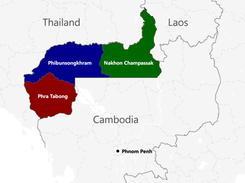
English: The territories of Cambodia and Laos annexed by Thailand in 1941, according to "ประกาศ ใช้อนุสัญญาสันติภาพและบรรดาภาคผนวก ระหว่างไทยและฝรั่งเศส", regrouped as in the map. |
| Date | |
| Source | Own work |
| Author | Murashel, edited by: Thanyakij |
Licensing
[edit]
- You are free:
- to share – to copy, distribute and transmit the work
- to remix – to adapt the work
- Under the following conditions:
- attribution – You must give appropriate credit, provide a link to the license, and indicate if changes were made. You may do so in any reasonable manner, but not in any way that suggests the licensor endorses you or your use.
- share alike – If you remix, transform, or build upon the material, you must distribute your contributions under the same or compatible license as the original.
File history
Click on a date/time to view the file as it appeared at that time.
| Date/Time | Thumbnail | Dimensions | User | Comment | |
|---|---|---|---|---|---|
| current | 04:48, 23 July 2017 | | 1,200 × 900 (187 KB) | Aquapatinth (talk | contribs) | change - southern border of Phibulsongkhram and Nakhon Champassak Provinces to the 13.5th parallel and - southeastern border of Phibulsongkhram to meridian line from the point which border line between Siem Reap and Battanbang Province met Tonle Sap.... |
| 07:19, 16 February 2016 |  | 1,001 × 921 (303 KB) | Xufanc (talk | contribs) | corrected spelling | |
| 05:49, 12 February 2016 |  | 1,001 × 921 (303 KB) | Xufanc (talk | contribs) | Added missing part of Nakhon Champassak Province | |
| 17:46, 25 September 2014 |  | 1,000 × 903 (308 KB) | RJFF (talk | contribs) | Somehow the revert did not work. | |
| 17:38, 25 September 2014 |  | 1,000 × 903 (308 KB) | RJFF (talk | contribs) | Reverted to version as of 17:36, 25 September 2014 | |
| 17:37, 25 September 2014 |  | 1,000 × 903 (308 KB) | RJFF (talk | contribs) | Reverted to version as of 18:43, 30 December 2013 | |
| 17:36, 25 September 2014 |  | 1,000 × 903 (308 KB) | RJFF (talk | contribs) | Reverted to version as of 18:43, 30 December 2013: The other version seems to be more accurate, see [http://daravireak.files.wordpress.com/2012/10/map_thailand_3province_indochine.png here], [http://www.websitesrcg.com/border/maps/indochina-1942.jpg he... | |
| 15:32, 9 February 2014 |  | 1,000 × 903 (321 KB) | Murashel (talk | contribs) | In Peace treaty in Tokyo Thais gain territory of Koh Kong. | |
| 18:43, 30 December 2013 |  | 1,000 × 903 (308 KB) | Derkommander0916 (talk | contribs) | Thailand never took Koh Kong and Pursat Refer this: http://www.geographicus.com/P/AntiqueMap/Thailand-japanese-1943 | |
| 15:01, 9 June 2013 |  | 1,000 × 903 (321 KB) | Murashel (talk | contribs) | User created page with UploadWizard |
You cannot overwrite this file.
File usage on Commons
There are no pages that use this file.
File usage on other wikis
The following other wikis use this file:
- Usage on ar.wikipedia.org
- Usage on ca.wikipedia.org
- Usage on en.wikipedia.org
- Usage on es.wikipedia.org
- Usage on fa.wikipedia.org
- Usage on fr.wikipedia.org
- Usage on he.wikipedia.org
- Usage on it.wikipedia.org
- Usage on ja.wikipedia.org
- Usage on km.wikipedia.org
- Usage on lo.wikipedia.org
- Usage on nl.wikipedia.org
- Usage on pl.wikipedia.org
- Usage on ru.wikipedia.org
- Usage on th.wikipedia.org
- Usage on vi.wikipedia.org
- Usage on zh.wikipedia.org