File:Railway stations on departure from Paris map-fr.svg
跳转到导航
跳转到搜索

此SVG文件的PNG预览的大小:600 × 600像素。 其他分辨率:240 × 240像素 | 480 × 480像素 | 768 × 768像素 | 1,024 × 1,024像素 | 2,048 × 2,048像素 | 1,400 × 1,400像素。
原始文件 (SVG文件,尺寸为1,400 × 1,400像素,文件大小:1.92 MB)
说明
说明
添加一行文字以描述该文件所表现的内容
摘要[编辑]
| 描述 |
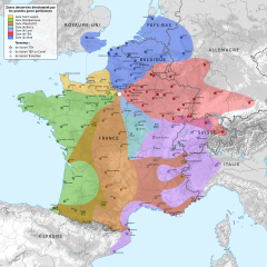
English: Railway stations and area directly served by trains on departure from Paris, France.
Français : Zones desservies directement par des trains en provenance de Paris, France. |
||
| 日期 | |||
| 来源 |
|
||
| 作者 | |||
| 其他版本 |
| ||
| 署名 (由许可协议要求) | © Sémhur / Wikimedia Commons / | ||
| SVG | W3C-validity not checked.
|
||
| Graphic Lab |


| 相机位置 | | 在以下服务上查看本图像和附近其他图像: OpenStreetMap |
|---|
许可协议[编辑]
我,本作品著作权人,特此采用以下许可协议发表本作品:
| 非营利著作权:本艺术作品是自由的,您可以依据自由艺术作品许可协议的条款传播和/或修改本艺术作品。您可以在Copyleft Attitude网站或其他网站找到该许可协议的样本。 |
This file is licensed under the Creative Commons Attribution-Share Alike Attribution-Share Alike 4.0 International, 3.0 Unported, 2.5 Generic, 2.0 Generic and 1.0 Generic license.
- 您可以自由地:
- 共享 – 复制、发行并传播本作品
- 修改 – 改编作品
- 惟须遵守下列条件:
- 署名 – 您必须对作品进行署名,提供授权条款的链接,并说明是否对原始内容进行了更改。您可以用任何合理的方式来署名,但不得以任何方式表明许可人认可您或您的使用。
- 相同方式共享 – 如果您再混合、转换或者基于本作品进行创作,您必须以与原先许可协议相同或相兼容的许可协议分发您贡献的作品。
您可以选择您需要的许可协议。

|
此图片的光栅版本可用。如果效果更好,那么该栅格图片应当替换本图片。
File:Railway stations on departure from Paris map-fr.svg → File:Railway stations on departure from Paris map-fr.png
通常,最好使用好的矢量版本(SVG)。 |
 |
文件历史
点击某个日期/时间查看对应时刻的文件。
| 日期/时间 | 缩略图 | 大小 | 用户 | 备注 | |
|---|---|---|---|---|---|
| 当前 | 2014年12月11日 (四) 21:26 | | 1,400 × 1,400(1.92 MB) | Sémhur(留言 | 贡献) | Nouveau fond de carte ; mise à jour des lignes. |
| 2014年5月30日 (五) 09:00 |  | 2,000 × 1,898(1.33 MB) | Sémhur(留言 | 贡献) | Valid SVG | |
| 2011年7月28日 (四) 08:34 |  | 2,000 × 1,898(1.34 MB) | Sémhur(留言 | 贡献) | Pontoise can be joined by both Saint-Lazare and Gare du Nord. | |
| 2011年1月18日 (二) 18:57 |  | 2,000 × 1,898(1.33 MB) | Sémhur(留言 | 贡献) | + Figueras | |
| 2011年1月17日 (一) 22:28 |  | 2,000 × 1,898(1.35 MB) | Gonioul(留言 | 贡献) | Lazare with 1 r | |
| 2009年12月22日 (二) 12:29 |  | 2,000 × 1,898(1.35 MB) | Sémhur(留言 | 贡献) | 2 - Railway stations on departure from Paris map-fr.svg | |
| 2009年12月5日 (六) 00:42 |  | 2,000 × 1,898(9.61 MB) | Gonioul(留言 | 贡献) | embedded bitmap somewhere? | |
| 2009年4月23日 (四) 12:01 |  | 2,000 × 1,898(9.59 MB) | Rigil~commonswiki(留言 | 贡献) | {{Information |Description={{fr|1=Zones desservies directement par des trains en provenance de Paris.}} |Source=travail personnel (own work) |Author=Rigil |Date=23 Avril 2009 |Permission= |other_versions= }} <!--{{ImageUpload|full}}--> [[C |
您不可以覆盖此文件。
文件用途
以下3个页面使用本文件:
全域文件用途
以下其他wiki使用此文件:
- als.wikipedia.org上的用途
- de.wikipedia.org上的用途
- de.wikivoyage.org上的用途
- en.wikipedia.org上的用途
- eo.wikipedia.org上的用途
- fr.wikipedia.org上的用途
- Gare de Paris-Nord
- Paris-Gare-de-Lyon
- Gare de Paris-Est
- Gare de Paris-Montparnasse
- Liste des gares de Paris
- Gare de Paris-Saint-Lazare
- Gare de Limoges-Bénédictins
- Gare de Provins
- Gare de Besançon-Viotte
- Wikipédia:Atelier graphique/Cartes/Archives/décembre 2009
- Wikipédia:Atelier graphique/Cartes/Archives/décembre 2014
- he.wikipedia.org上的用途
- ja.wikipedia.org上的用途
- lb.wikipedia.org上的用途
- nl.wikipedia.org上的用途
- nl.wikivoyage.org上的用途
- no.wikipedia.org上的用途
- pt.wikipedia.org上的用途
查看本文件的更多全域用途。