File:San Gabiel fault.jpg
Jump to navigation
Jump to search
No higher resolution available.
San_Gabiel_fault.jpg (214 × 218 pixels, file size: 61 KB, MIME type: image/jpeg)
Captions
Captions
Add a one-line explanation of what this file represents
Summary
[edit]
| Description |
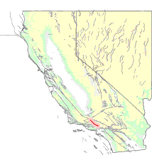
English: Map of the San Gabriel Fault — along the southwestern face of the Western San Gabriel Mountains, in Southern California.
|
|||
| Date | ||||
| Source | http://quake.usgs.gov/info/faultmaps/fault213.html | |||
| Author | Unknown author | |||
| Permission (Reusing this file) |
|
File history
Click on a date/time to view the file as it appeared at that time.
| Date/Time | Thumbnail | Dimensions | User | Comment | |
|---|---|---|---|---|---|
| current | 00:59, 31 May 2007 | | 214 × 218 (61 KB) | Evrik (talk | contribs) | == Summary == {{Information |Description=USGS diagram of San Gabriel Fault |Source=http://quake.usgs.gov/info/faultmaps/fault213.html |Date=May 30, 2007 |Author=Unknown |Permission={{PD-USGov-USGS}} }} |
You cannot overwrite this file.
File usage on Commons
The following page uses this file:
File usage on other wikis
The following other wikis use this file:
- Usage on en.wikipedia.org
- Usage on www.wikidata.org