File:Sanfrancisco haight printmap.png
Jump to navigation
Jump to search
Size of this preview: 800 × 460 pixels. Other resolutions: 320 × 184 pixels | 640 × 368 pixels | 1,024 × 589 pixels | 1,280 × 736 pixels | 3,008 × 1,730 pixels.
Original file (3,008 × 1,730 pixels, file size: 1.25 MB, MIME type: image/png)
Captions
Captions
Add a one-line explanation of what this file represents

|
This file was moved to Wikimedia Commons from wts.oldwikivoyage using a bot script. All source information is still present. It requires review. Additionally, there may be errors in any or all of the information fields; information on this file should not be considered reliable and the file should not be used until it has been reviewed and any needed corrections have been made. Once the review has been completed, this template should be removed. For details about this file, see below. Check now! |
Summary[edit]
| Description |
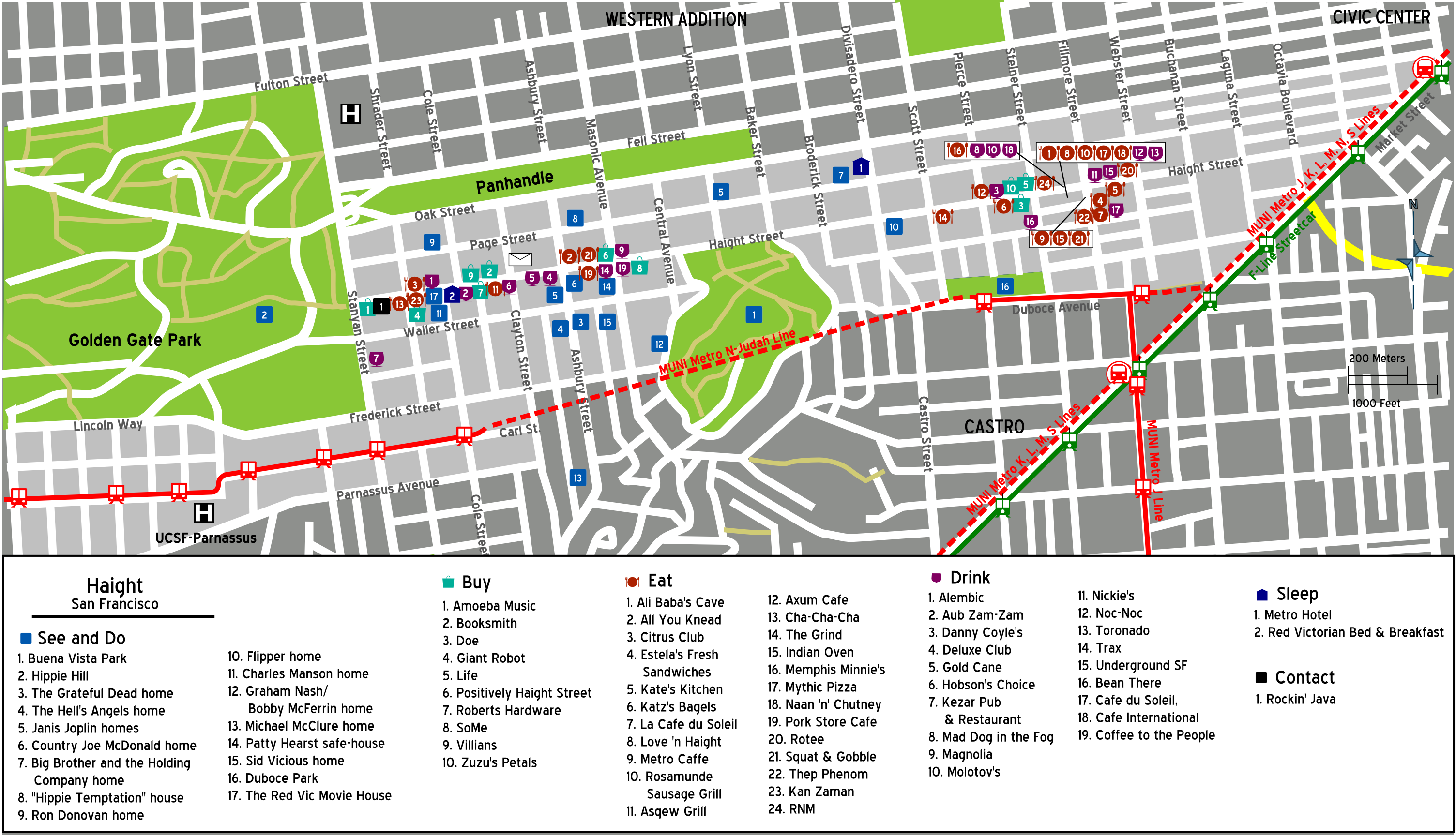
Haight, San Francisco Map. Print-friendly version of the Haight map. For a more computer-friendly version, see :Image:Sanfrancisco haight map.PNG., San Francisco
|
| Date | |
| Source | :Image:Sanfrancisco haight printmap.svg |
| Author | User: PerryPlanet |
Licensing[edit]
This file is licensed under the Creative Commons Attribution-Share Alike Attribution-Share Alike 4.0 International, 3.0 Unported, 2.5 Generic, 2.0 Generic and 1.0 Generic license.
- You are free:
- to share – to copy, distribute and transmit the work
- to remix – to adapt the work
- Under the following conditions:
- attribution – You must give appropriate credit, provide a link to the license, and indicate if changes were made. You may do so in any reasonable manner, but not in any way that suggests the licensor endorses you or your use.
- share alike – If you remix, transform, or build upon the material, you must distribute your contributions under the same or compatible license as the original.
Original upload log[edit]
| This file was imported from Wikivoyage WTS. |
The original description page was here. All following user names refer to wts.wikivoyage-old.
- 2009-05-03 00:18 (WT-shared) PerryPlanet archive copy at the Wayback Machine 3008×1730 (1477253 bytes) {{Imagecredit|credit=User: PerryPlanet|captureDate=5/2/09|location=San Francisco|source=[[Image:Sanfrancisco haight printmap.svg]]|caption=H (Import from wikitravel.org/shared)
- 2009-05-20 02:45 (WT-shared) PerryPlanet archive copy at the Wayback Machine 3008×1730 (1486971 bytes) (Import from wikitravel.org/shared)
- 2010-02-27 03:40 (WT-shared) PerryPlanet archive copy at the Wayback Machine 3008×1730 (1478033 bytes) (Import from wikitravel.org/shared)
- 2011-06-22 03:38 (WT-shared) PerryPlanet archive copy at the Wayback Machine 3008×1730 (1341148 bytes) (Import from wikitravel.org/shared)
- 2012-09-09 21:03 Shaund[dead link] 3008×1730 (1312011 bytes) rmv logo
File history
Click on a date/time to view the file as it appeared at that time.
| Date/Time | Thumbnail | Dimensions | User | Comment | |
|---|---|---|---|---|---|
| current | 04:44, 20 December 2012 | | 3,008 × 1,730 (1.25 MB) | OgreBot (talk | contribs) | (BOT): Reverting to most recent version before archival |
| 04:44, 20 December 2012 |  | 3,008 × 1,730 (1.28 MB) | OgreBot (talk | contribs) | (BOT): Uploading old version of file from wts.wikivoyage; originally uploaded on 2011-06-22 03:38:24 by (WT-shared) PerryPlanet | |
| 04:44, 20 December 2012 |  | 3,008 × 1,730 (1.41 MB) | OgreBot (talk | contribs) | (BOT): Uploading old version of file from wts.wikivoyage; originally uploaded on 2010-02-27 03:40:58 by (WT-shared) PerryPlanet | |
| 04:44, 20 December 2012 |  | 3,008 × 1,730 (1.42 MB) | OgreBot (talk | contribs) | (BOT): Uploading old version of file from wts.wikivoyage; originally uploaded on 2009-05-20 02:45:51 by (WT-shared) PerryPlanet | |
| 04:44, 20 December 2012 |  | 3,008 × 1,730 (1.41 MB) | OgreBot (talk | contribs) | (BOT): Uploading old version of file from wts.wikivoyage; originally uploaded on 2009-05-03 00:18:53 by (WT-shared) PerryPlanet | |
| 02:27, 18 November 2012 |  | 3,008 × 1,730 (1.25 MB) | MGA73bot2 (talk | contribs) | {{BotMoveToCommons|wts.oldwikivoyage|year={{subst:CURRENTYEAR}}|month={{subst:CURRENTMONTHNAME}}|day={{subst:CURRENTDAY}}}} == {{int:filedesc}} == {{Information |description=Haight, San Francisco Map. Print-friendly version of the Haight map. For a mor... |
You cannot overwrite this file.
File usage on Commons
There are no pages that use this file.