File:Schweden und Norwegen LOC 2012593350.tif
Jump to navigation
Jump to search

Size of this JPG preview of this TIF file: 555 × 600 pixels. Other resolutions: 222 × 240 pixels | 444 × 480 pixels | 711 × 768 pixels | 948 × 1,024 pixels | 1,896 × 2,048 pixels | 6,974 × 7,534 pixels.
Original file (6,974 × 7,534 pixels, file size: 150.32 MB, MIME type: image/tiff)
Captions
Captions
Add a one-line explanation of what this file represents
Summary[edit]
| Description |
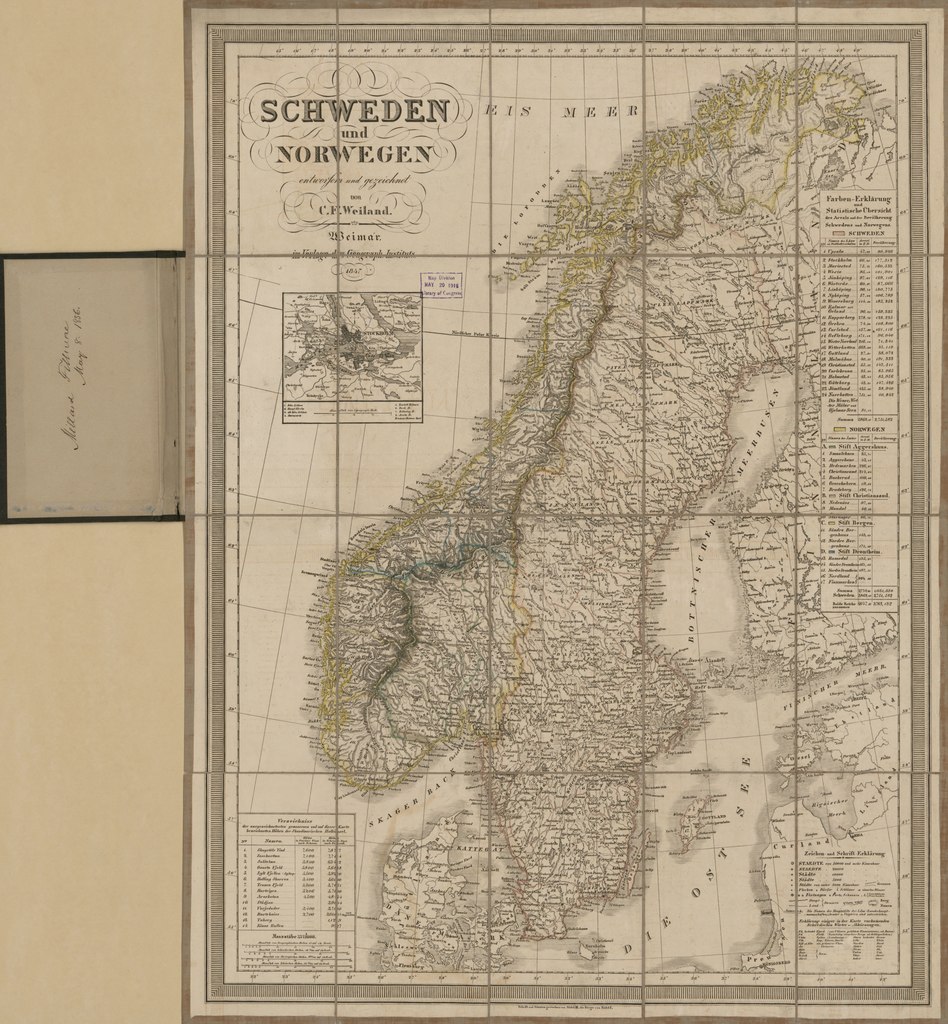
English: Relief shown by hachures. Hand colored to emphasize coastlines and international boundaries. Map in German; cover title in English. Prime meridian: Ferro. Signed in inked handwriting on paper label affixed at head of cover title: Sweden, No. 67, Millard Fillmore, May 8, 1856; and in inked handwriting on verso of same cover panel: Millard Fillmore, May 8, 1856. LC copy imperfect: Sectioned to 20 panels to enable folding, cloth hemmed, torn at fold lines, taped. Includes notes, indexed statistical tables, inset of Stockholm city region, 4 bar scales, and key to abbreviations. Available also through the Library of Congress Web site as a raster image. |
||
| Title | Schweden und Norwegen | ||
| Shelf ID | G6950 1847 .W4 | ||
| Date | |||
| Source | https://www.loc.gov/item/2012593350/ | ||
| Author | Weiland, C. F. (Carl Ferdinand); Fillmore, Millard; Geographisches Institut (Weimar, Thuringia, Germany); Weiland, C. F. | ||
| Permission (Reusing this file) |
|
||
| Other versions |
|
||
| Location | Stockholm Region · Sweden · Norway | ||
| Part of | American Memory · General Maps · Catalog · Geography And Map Division | ||
| Subject | Maps · Sweden · Norway · Stockholm Region (Sweden) |


Licensing[edit]
|
This is a faithful photographic reproduction of a two-dimensional, public domain work of art. The work of art itself is in the public domain for the following reason:
The official position taken by the Wikimedia Foundation is that "faithful reproductions of two-dimensional public domain works of art are public domain".
This photographic reproduction is therefore also considered to be in the public domain in the United States. In other jurisdictions, re-use of this content may be restricted; see Reuse of PD-Art photographs for details. | ||||
File history
Click on a date/time to view the file as it appeared at that time.
| Date/Time | Thumbnail | Dimensions | User | Comment | |
|---|---|---|---|---|---|
| current | 22:46, 9 June 2018 |  | 6,974 × 7,534 (150.32 MB) | Fæ (talk | contribs) | LOC Maps https://www.loc.gov/item/2012593350/ #10043 |
You cannot overwrite this file.
File usage on Commons
The following page uses this file: