File:ShepherdByzempire1265.jpg
跳至導覽
跳至搜尋
預覽大小:762 × 599 像素。 其他解析度:305 × 240 像素 | 610 × 480 像素 | 976 × 768 像素 | 1,144 × 900 像素。
原始檔案 (1,144 × 900 像素,檔案大小:281 KB,MIME 類型:image/jpeg)
說明
說明
添加單行說明來描述出檔案所代表的內容
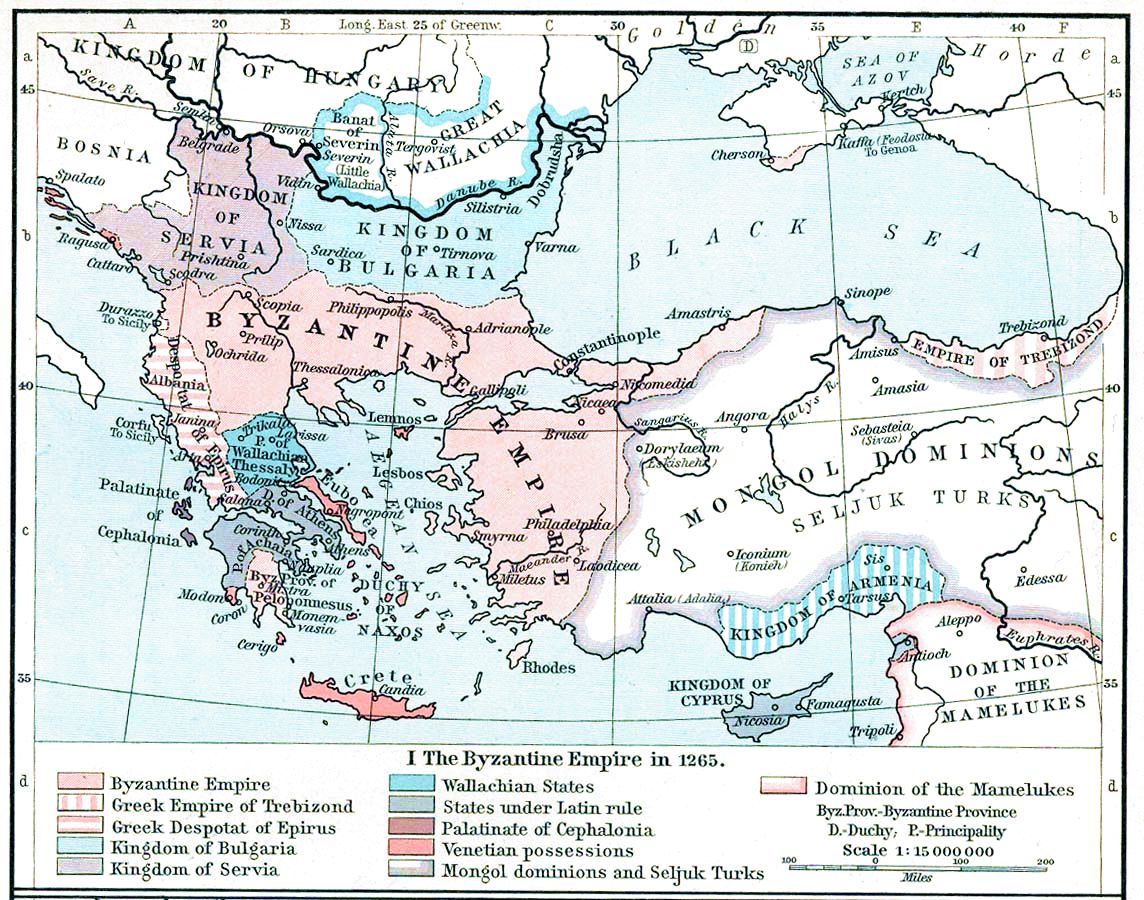
The Byzantine Empire and the Frankish states of Greece in 1265. Map from William R. Shepherd's Historical Atlas (1911)
摘要
[編輯]| 描述 | Map, The Byzantine Empire, 1265. |
| 日期 | |
| 來源 | The Historical Atlas, William R. Shepherd, 1911. |
| 作者 | |
| 其他版本 |
Derivative works of this file: |

|
本圖片是以PNG、GIF或JPEG格式上傳。然而,其中包含的資料或訊息,應該重新建立成可縮放向量圖形(SVG)檔案,以更有效率或更準確的方式儲存。如有可能,請上傳本圖片的SVG格式版本。在上傳之後,請修改維基各姊妹計畫中所有使用舊版圖片的條目(列在圖像連結章節中),替換為新版圖片,並在舊圖片的描述頁中加入{{Vector version available|新圖片名稱.svg}}模板,同時移除本模板。
|


授權條款
[編輯]
|
本作品在其來源國以及其他版權期限是作者逝世後70年或以下的國家與地區屬於公有領域。
| |
| 此作品無已知的著作權限制,亦不受所有相關和鄰接的權利限制。 | |
|
|
 | |
 |
檔案歷史
點選日期/時間以檢視該時間的檔案版本。
| 日期/時間 | 縮圖 | 尺寸 | 用戶 | 備註 | |
|---|---|---|---|---|---|
| 目前 | 2022年11月16日 (三) 15:28 | | 1,144 × 900(281 KB) | Gyalu22(對話 | 貢獻) | Reverted to version as of 16:26, 12 July 2009 (UTC) |
| 2016年5月20日 (五) 14:49 |  | 1,144 × 900(858 KB) | Julieta39(對話 | 貢獻) | Cosmetic (see discussion file) | |
| 2009年7月12日 (日) 16:26 |  | 1,144 × 900(281 KB) | Alex:D(對話 | 貢獻) | whitened | |
| 2009年7月12日 (日) 16:17 |  | 1,144 × 900(281 KB) | Alex:D(對話 | 貢獻) | whitened | |
| 2009年7月12日 (日) 16:12 |  | 1,144 × 900(281 KB) | Alex:D(對話 | 貢獻) | whitened | |
| 2004年12月21日 (二) 13:40 |  | 1,144 × 900(272 KB) | Mschlindwein(對話 | 貢獻) | Map, The Byzantine Empire, 1265. The Historical Atlas, William R. Shepherd, 1911. |
無法覆蓋此檔案。
檔案用途
下列22個頁面有用到此檔案:
- Atlas of Albania
- Atlas of Bosnia and Herzegovina
- Atlas of Cyprus
- Atlas of Greece
- Atlas of Kosovo
- Atlas of Montenegro
- Atlas of North Macedonia
- Atlas of Northern Cyprus
- Atlas of Republika Srpska
- Atlas of Serbia
- Atlas of Turkey
- Atlas of ancient Rome
- Atlas of the Byzantine Empire
- Byzantine Empire
- Top 200 JPG images that should use vector graphics
- User:J budissin/Uploads/BiH/2016 May 11-20
- User:Jaqeli/Georgia
- User:Mschlindwein/images
- File:Balkans 1265.jpg
- File:ByzantinischesReich1265-pt.svg
- File:Empire-byzantin-1265.svg
- File:ShepherdByzempire1265-ar.jpg
全域檔案使用狀況
以下其他 wiki 使用了這個檔案:
- an.wikipedia.org 的使用狀況
- ar.wikipedia.org 的使用狀況
- azb.wikipedia.org 的使用狀況
- az.wikipedia.org 的使用狀況
- be-tarask.wikipedia.org 的使用狀況
- be.wikipedia.org 的使用狀況
- bg.wikipedia.org 的使用狀況
- ca.wikipedia.org 的使用狀況
- cs.wikipedia.org 的使用狀況
- de.wikipedia.org 的使用狀況
- el.wikipedia.org 的使用狀況
- en.wikipedia.org 的使用狀況
檢視此檔案的更多全域使用狀況。
詮釋資料
分類:
- Maps of the Byzantine empire in the 13th century
- Maps showing history by William R. Shepherd
- Maps of the history of Romania in the Middle Ages
- Romania in the 13th century
- Banate of Severin
- Maps of the Kingdom of Serbia (medieval)
- Maps of 13th-century Serbia
- Maps of 13th-century Bulgaria
- Maps of the Armenian Kingdom of Cilicia
- Maps showing 1265