File:St. Lucia; done from surveys and observations made by the English whilst in their possession. LOC 73697046.tif
Jump to navigation
Jump to search

Size of this JPG preview of this TIF file: 473 × 599 pixels. Other resolutions: 189 × 240 pixels | 379 × 480 pixels | 606 × 768 pixels | 808 × 1,024 pixels | 1,617 × 2,048 pixels | 5,835 × 7,391 pixels.
Original file (5,835 × 7,391 pixels, file size: 123.39 MB, MIME type: image/tiff)
Captions
Captions
Add a one-line explanation of what this file represents
Summary[edit]
| Description |
English: Scale ca. 1:75,000. Hand colored. Relief shown by hachures. LC copy sectioned and mounted on cloth backing. Shows plantations, anchorages for large vessels, and for ships of 50 tons. Includes inset "Plan of the Carenage." LC Maps of North America, 1750-1789, 2070 Available also through the Library of Congress Web site as a raster image. Vault AACR2 |
||
| Title | St. Lucia; done from surveys and observations made by the English whilst in their possession. | ||
| Shelf ID | G5110 1775 .J4 | ||
| Date | |||
| Source | https://www.loc.gov/item/73697046/ | ||
| Author | Jefferys, Thomas; Sayer, Robert | ||
| Permission (Reusing this file) |
|
||
| Other versions |
|
||
| Location | Saint Lucia. · Saint Lucia | ||
| Part of | Military Battles And Campaigns · American Memory · Catalog · Geography And Map Division · American Revolution And Its Era: Maps And Charts Of North America And The West Indies, 1750-1789 | ||
| Subject | Maps · Saint Lucia · Early Works To 1800 |


Licensing[edit]
|
This is a faithful photographic reproduction of a two-dimensional, public domain work of art. The work of art itself is in the public domain for the following reason:
The official position taken by the Wikimedia Foundation is that "faithful reproductions of two-dimensional public domain works of art are public domain".
This photographic reproduction is therefore also considered to be in the public domain in the United States. In other jurisdictions, re-use of this content may be restricted; see Reuse of PD-Art photographs for details. | ||||
File history
Click on a date/time to view the file as it appeared at that time.
| Date/Time | Thumbnail | Dimensions | User | Comment | |
|---|---|---|---|---|---|
| current | 13:21, 26 December 2018 | 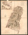 | 5,835 × 7,391 (123.39 MB) | Fæ (talk | contribs) | LOC Maps https://www.loc.gov/item/73697046/ #24660 |
You cannot overwrite this file.
File usage on Commons
The following page uses this file: