File:Stanton on the corner, Watching all the cars go by (geograph 3203250).jpg
Jump to navigation
Jump to search

Size of this preview: 800 × 600 pixels. Other resolutions: 320 × 240 pixels | 640 × 480 pixels | 1,024 × 768 pixels | 1,280 × 960 pixels | 2,592 × 1,944 pixels.
Original file (2,592 × 1,944 pixels, file size: 2.84 MB, MIME type: image/jpeg)
Captions
Captions
Add a one-line explanation of what this file represents
Summary
[edit].jpg&action=edit§ion=1)
| Description |
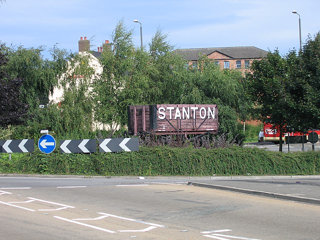
English: Stanton on the corner, Watching all the cars go by The Stanton Iron Works, south of Ilkeston, was once a major employer in Ilkeston and had a considerable network of internal railways. Although the works still survive under the French company, Saint Gobain, it is very much smaller. One of the company's wagons has been placed on this roundabout along the town centre relief road as a reminder of past glories. Ironically it is virtually on the site of one of Ilkeston's former three stations, Ilkeston Town, which closed in 1947. The quantity of shrubbery on the roundabout has been considerably reduced since this photograph was taken. |
| Date | |
| Source | From geograph.org.uk |
| Author | A-M-Jervis |
| Permission (Reusing this file) |
Creative Commons Attribution Share-alike license 2.0 |
| Attribution (required by the license) | A-M-Jervis / Stanton on the corner, Watching all the cars go by / |
| Camera location | | View this and other nearby images on: OpenStreetMap |
|---|
.jpg¶ms=052.977032_N_-001.309390_E_globe:Earth_type:camera_source:geograph-osgb36(SK46474241)_heading:22.00&language=en)
| Object location | | View this and other nearby images on: OpenStreetMap |
|---|
.jpg¶ms=052.977390_N_-001.309090_E_globe:Earth_class:object_type:object_source:geograph-osgb36(SK46494245)_heading:22.00&language=en)
Licensing
[edit].jpg&action=edit§ion=2)

|
This image was taken from the Geograph project collection. See this photograph's page on the Geograph website for the photographer's contact details. The copyright on this image is owned by A-M-Jervis and is licensed for reuse under the Creative Commons Attribution-ShareAlike 2.0 license.
|
This file is licensed under the Creative Commons Attribution-Share Alike 2.0 Generic license.
Attribution: A-M-Jervis
- You are free:
- to share – to copy, distribute and transmit the work
- to remix – to adapt the work
- Under the following conditions:
- attribution – You must give appropriate credit, provide a link to the license, and indicate if changes were made. You may do so in any reasonable manner, but not in any way that suggests the licensor endorses you or your use.
- share alike – If you remix, transform, or build upon the material, you must distribute your contributions under the same or compatible license as the original.
File history
Click on a date/time to view the file as it appeared at that time.
| Date/Time | Thumbnail | Dimensions | User | Comment | |
|---|---|---|---|---|---|
| current | 22:27, 3 January 2021 | | 2,592 × 1,944 (2.84 MB) | Lamberhurst (talk | contribs) | Transferred from geograph.co.uk using [https://tools.wmflabs.org/geograph2commons/ geograph2commons] |
You cannot overwrite this file.
File usage on Commons
The following page uses this file:
.jpg&oldid=858243226)