File:StateLibQld 2 119348 Map of Brisbane, 1844.jpg
Original file (1,000 × 734 pixels, file size: 123 KB, MIME type: image/jpeg)
Captions
Captions
Summary
[edit]
| Description |
English: Map of Brisbane, 1844
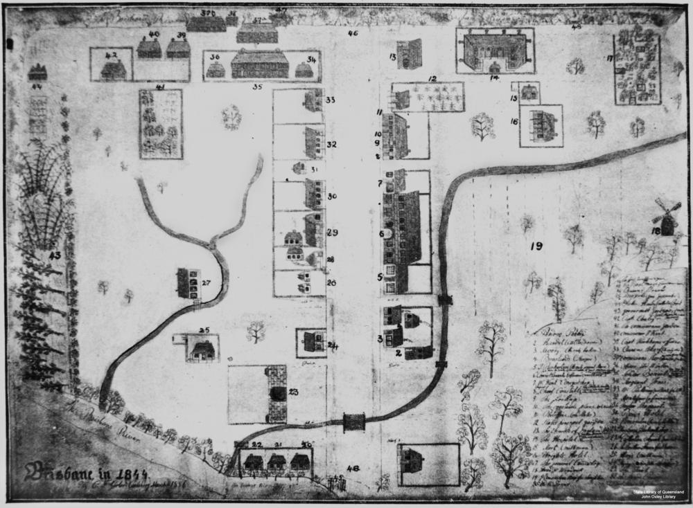
Map of Brisbane drawn by C. F. Gerler. This basic map has a numbered list of forty-eight locations in the bottom right corner. The list corresponds to places and residences on the map. The locations are represented by hand drawings of houses and other buildings with the numbers next to them. Trees, roads, and rivers are have also been included as a decorative flourish. Caption: Brisbane in 1844. Map legend : 1. Andrew Petrie, 2, Handel, cattle drover, 3. Savory (the only baker), 4. Bensteads, sawyers, 5. T. Richardtson (the only general store), 6. Convict Barracks, 7. W. Kent (druggist shop), 8. Fitzpatrick (the first Chief Constable), 9. The Lock-up, 10. The Constable's place (only two in all), 11. Slate's Post Office (old), 12. Slate's Pineapple Garden, 13. Church of England, 14. The Hospital, 15. Mort, milkman. 16. Wright's Hotel, 17. General Cemetery, 18. Tread and Windmill, 19. Edmonston.s Paddock, 20. Old R. Jones, 21. Dr. Simpson (the first Commissioner), 22. Old Major Prior, 23. The Gaol, 24. Skyring's Beehives (soft goods shop), 25. Hayes, milkman, 26. Brothers Fraser (first houses), 27. Catholic Church, 28. McLean's Blacksmith's Shop, 29. Edmonston's butcher, 30. Bow's Hotel. 31. Taylor Shappart, 32. Montifeur (a financier), 33. W. Pickering, 34. Sergeant Jones, 35. Soldiers' Barracks, 36. Officer de Winton, 37. Commission Stores, 38. Queen's Wharf, 39. Captain Wickham's office, 40. Commissioner T. Kent, 41. Commissioner's Garden, 42. Captain Coley, 43. Government Gardens, 44. Father Hanley (the only priest), 45. Saw Pits, 46. Queen Street, 47. The Boat House and Boatman's House, 48. The First Tombstone (two graves). (Description supplied with photograph.). |
| Date | |
| Source | Copied and digitised from an image appearing in Jubilee History of Queensland, edited by E.J.T. Barton. Brisbane : H.J. Diddams & Co., 1909, p. 12 |
| Author | Gerler, C.F. |
Licensing
[edit]
This image or other work is of Australian origin and is now in the public domain because its term of copyright has expired. According to the Australian Copyright Council (ACC), ACC Information Sheet G023v19 (Duration of copyright) (January 2019).1
When using this template, please provide information of where the image was first published and who created it. |
 | |||||||||||||||||||

|
This image has been digitised by the State Library of Queensland, and provided to the Wikimedia Commons as part of a cooperative project. The original photograph is in the public domain. The metadata has been released by State Library of Queensland under the Creative Commons Attribution-Share Alike 2.5 license.
|
File history
Click on a date/time to view the file as it appeared at that time.
| Date/Time | Thumbnail | Dimensions | User | Comment | |
|---|---|---|---|---|---|
| current | 12:43, 21 May 2013 | | 1,000 × 734 (123 KB) | SLQbot (talk | contribs) | =={{int:filedesc}}== {{Information |description={{en|1=Map of Brisbane, 1844 Map of Brisbane drawn by C. F. Gerler. This basic map has a numbered list of forty-eight locations in the bottom right corner. The list corresponds to places and residences on... |
You cannot overwrite this file.
File usage on Commons
There are no pages that use this file.
File usage on other wikis
The following other wikis use this file:
- Usage on de.wikipedia.org
- Usage on en.wikipedia.org