File:StateLibQld 2 130499 Witton Township real estate map, Indooroopilly, Brisbane, ca. 1880s.jpg
Jump to navigation
Jump to search

Size of this preview: 800 × 509 pixels. Other resolutions: 320 × 204 pixels | 640 × 407 pixels | 1,000 × 636 pixels.
Original file (1,000 × 636 pixels, file size: 130 KB, MIME type: image/jpeg)
Captions
Captions
Add a one-line explanation of what this file represents
Summary
[edit]
| Description |
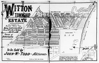
English: Witton Township real estate map, Indooroopilly, Brisbane, ca. 1880s
The property of Andrew Bogle Esq. To be sold by John w. Todd, Auctioneer. The land in this direction having an area of over 70 acres with extensive river frontages and beautiful sites, will be sold in lots to suit purchasers requiring from 5 to 30 acres. (information on map) Map includes Ormond Terrace, Witton Road, Spring Street, Boundary Road, Bridge Street, Maud Street, Market Street, Rennies Road and shows the location of Witton Manor. |
| Date | between 1880 and 1890 |
| Source | Item is held by John Oxley Library, State Library of Queensland. |
| Author |
Licensing
[edit]
This image or other work is of Australian origin and is now in the public domain because its term of copyright has expired. According to the Australian Copyright Council (ACC), ACC Information Sheet G023v19 (Duration of copyright) (January 2019).1
When using this template, please provide information of where the image was first published and who created it. |
 | |||||||||||||||||||

|
This image has been digitised by the State Library of Queensland, and provided to the Wikimedia Commons as part of a cooperative project. The original photograph is in the public domain. The metadata has been released by State Library of Queensland under the Creative Commons Attribution-Share Alike 2.5 license.
|
File history
Click on a date/time to view the file as it appeared at that time.
| Date/Time | Thumbnail | Dimensions | User | Comment | |
|---|---|---|---|---|---|
| current | 05:00, 14 May 2013 | | 1,000 × 636 (130 KB) | SLQbot (talk | contribs) | =={{int:filedesc}}== {{Information |description={{en|1=Witton Township real estate map, Indooroopilly, Brisbane, ca. 1880s The property of Andrew Bogle Esq. To be sold by John w. Todd, Auctioneer. The land in this direction having an area of over 70 ac... |
You cannot overwrite this file.
File usage on Commons
There are no pages that use this file.
File usage on other wikis
The following other wikis use this file:
- Usage on en.wikipedia.org
- Usage on ms.wikipedia.org