File:Suriname regions map.svg
Jump to navigation
Jump to search

Size of this PNG preview of this SVG file: 488 × 599 pixels. Other resolutions: 195 × 240 pixels | 391 × 480 pixels | 625 × 768 pixels | 834 × 1,024 pixels | 1,668 × 2,048 pixels | 535 × 657 pixels.
Original file (SVG file, nominally 535 × 657 pixels, file size: 698 KB)
Captions
Captions
Add a one-line explanation of what this file represents
Summary[edit]
| Description |
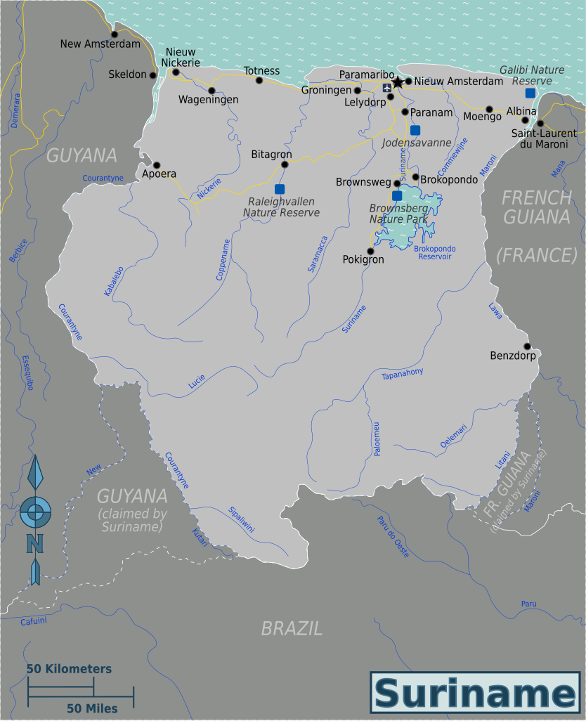
Map of Suriname (SVG). |
| Date | |
| Source | Own work based on Perry-Castañeda Library Map Collection - University of Texas Libraries |
| Author | Globe-trotter |
| Other versions | English, French, Russian |
.png)
Licensing[edit]
This file is licensed under the Creative Commons Attribution-Share Alike 4.0 International, 3.0 Unported, 2.5 Generic, 2.0 Generic and 1.0 Generic license.
- You are free:
- to share – to copy, distribute and transmit the work
- to remix – to adapt the work
- Under the following conditions:
- attribution – You must give appropriate credit, provide a link to the license, and indicate if changes were made. You may do so in any reasonable manner, but not in any way that suggests the licensor endorses you or your use.
- share alike – If you remix, transform, or build upon the material, you must distribute your contributions under the same or compatible license as the original.
Original upload log[edit]
| This file was imported from Wikivoyage WTS. |
The original description page was here. All following user names refer to wts.wikivoyage-old.
- 2010-01-15 04:30 (WT-shared) Globe-trotter[dead link] 409×329 (599072 bytes) {{Imagecredit|credit=Globe-trotter|captureDate=January 15, 2009|location=Suriname|source=Perry-Castañeda Library Map Collection, University (Import from wikitravel.org/shared)
- 2010-01-15 04:49 (WT-shared) Globe-trotter[dead link] 409×329 (600967 bytes) small edits (Import from wikitravel.org/shared)
- 2010-01-15 04:58 (WT-shared) Globe-trotter[dead link] 409×329 (600958 bytes) small changes (Import from wikitravel.org/shared)
- 2010-01-24 18:31 (WT-shared) Globe-trotter[dead link] 409×329 (671924 bytes) added rivers, a national park and disputed boundaries (Import from wikitravel.org/shared)
- 2011-08-11 05:45 (WT-shared) Joelf[dead link] 409×329 (753883 bytes) +fr (Import from wikitravel.org/shared)
- 2012-10-31 14:54 Globe-trotter[dead link] 535×657 (712616 bytes) removing regions, not necessary yet
- 2012-10-31 15:18 Globe-trotter[dead link] 535×657 (715036 bytes) added Suriname dot
- 2012-11-01 17:55 Globe-trotter[dead link] 535×657 (715159 bytes) fixed river
File history
Click on a date/time to view the file as it appeared at that time.
| Date/Time | Thumbnail | Dimensions | User | Comment | |
|---|---|---|---|---|---|
| current | 13:46, 20 November 2012 | | 535 × 657 (698 KB) | OgreBot (talk | contribs) | (BOT): Reverting to most recent version before archival |
| 13:46, 20 November 2012 |  | 535 × 657 (698 KB) | OgreBot (talk | contribs) | (BOT): Uploading old version of file from wts.wikivoyage; originally uploaded on 2012-10-31 15:18:49 by Globe-trotter | |
| 13:46, 20 November 2012 |  | 535 × 657 (696 KB) | OgreBot (talk | contribs) | (BOT): Uploading old version of file from wts.wikivoyage; originally uploaded on 2012-10-31 14:54:42 by Globe-trotter | |
| 13:46, 20 November 2012 |  | 409 × 329 (736 KB) | OgreBot (talk | contribs) | (BOT): Uploading old version of file from wts.wikivoyage; originally uploaded on 2011-08-11 05:45:09 by (WT-shared) Joelf | |
| 13:46, 20 November 2012 |  | 409 × 329 (656 KB) | OgreBot (talk | contribs) | (BOT): Uploading old version of file from wts.wikivoyage; originally uploaded on 2010-01-24 18:31:12 by (WT-shared) Globe-trotter | |
| 13:46, 20 November 2012 |  | 409 × 329 (587 KB) | OgreBot (talk | contribs) | (BOT): Uploading old version of file from wts.wikivoyage; originally uploaded on 2010-01-15 04:58:29 by (WT-shared) Globe-trotter | |
| 13:46, 20 November 2012 |  | 409 × 329 (587 KB) | OgreBot (talk | contribs) | (BOT): Uploading old version of file from wts.wikivoyage; originally uploaded on 2010-01-15 04:49:06 by (WT-shared) Globe-trotter | |
| 13:46, 20 November 2012 |  | 409 × 329 (585 KB) | OgreBot (talk | contribs) | (BOT): Uploading old version of file from wts.wikivoyage; originally uploaded on 2010-01-15 04:30:08 by (WT-shared) Globe-trotter | |
| 02:57, 18 November 2012 |  | 535 × 657 (698 KB) | MGA73bot2 (talk | contribs) | {{BotMoveToCommons|wts.oldwikivoyage|year={{subst:CURRENTYEAR}}|month={{subst:CURRENTMONTHNAME}}|day={{subst:CURRENTDAY}}}} == {{int:filedesc}} == {{Information |description=Map of Suriname (SVG). * Map of: Suriname¤ |date=January 15, 2009 |source=Per... |
You cannot overwrite this file.
File usage on Commons
The following page uses this file: