File:Teapot Rock, near Green River Station. Sweetwater County, Wyoming. Small figure of man at foot of spout gives an indication of size of the rock. - NARA - 516618.gif
Teapot_Rock,_near_Green_River_Station._Sweetwater_County,_Wyoming._Small_figure_of_man_at_foot_of_spout_gives_an_indication_of_size_of_the_rock._-_NARA_-_516618.gif (600 × 467 pixels, file size: 89 KB, MIME type: image/gif)
Captions
Captions
Summary
[edit]
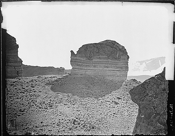
| Teapot Rock, near Green River Station. Sweetwater County, Wyoming. Small figure of man at foot of spout gives an indication of size of the rock.
( |
|||||||||||||||||||||||||||
|---|---|---|---|---|---|---|---|---|---|---|---|---|---|---|---|---|---|---|---|---|---|---|---|---|---|---|---|
| Author |
Jackson, William Henry, 1843-1942 (NARA record: 10580515) |
||||||||||||||||||||||||||
| Record creator | Department of the Interior. General Land Office. U.S. Geological and Geographic Survey of the Territories. (1874 - 6/30/1879) | ||||||||||||||||||||||||||
| Title |
Teapot Rock, near Green River Station. Sweetwater County, Wyoming. Small figure of man at foot of spout gives an indication of size of the rock. |
||||||||||||||||||||||||||
| Date | 1869 | ||||||||||||||||||||||||||
| Collection |
|
||||||||||||||||||||||||||
| Record ID |
|
||||||||||||||||||||||||||
| Source | U.S. National Archives and Records Administration | ||||||||||||||||||||||||||
| Other versions |
Please do not overwrite this file: any restoration work should be uploaded with a new name and linked in this page's "other versions=" parameter, so that this file represents the exact file found in the NARA catalog record to which it links. The metadata on this page was imported directly from NARA's catalog record; additional descriptive text may be added by Wikimedians to the template below with the "description=" parameter, but please do not modify the other fields. |
||||||||||||||||||||||||||
Licensing
[edit]
This file was provided to Wikimedia Commons by the National Archives and Records Administration as part of a cooperation project. The National Archives and Records Administration provides images depicting American and global history which are public domain or licensed under a free license.
|
This image is in the public domain in the United States because it only contains materials that originally came from the United States Geological Survey, an agency of the United States Department of the Interior. For more information, see the official USGS copyright policy.
|
File history
Click on a date/time to view the file as it appeared at that time.
| Date/Time | Thumbnail | Dimensions | User | Comment | |
|---|---|---|---|---|---|
| current | 06:48, 24 September 2017 | | 600 × 467 (89 KB) | US National Archives bot (talk | contribs) | Bot-assisted upload of US National Archives Identifer 516618. |
You cannot overwrite this file.
File usage on Commons
The following page uses this file: