File:The Tower Trig Point, Flamborough - geograph.org.uk - 835896.jpg
Jump to navigation
Jump to search

Size of this preview: 423 × 599 pixels. Other resolutions: 169 × 240 pixels | 452 × 640 pixels.
Original file (452 × 640 pixels, file size: 49 KB, MIME type: image/jpeg)
Captions
Captions
Add a one-line explanation of what this file represents
This is a photo of listed building number 1083400. |
Summary
[edit]
| Description |
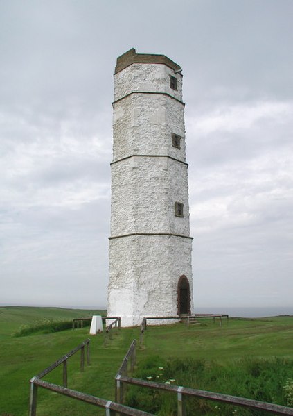
English: The Tower Trig Point, Flamborough, East Riding of Yorkshire, England. Triangulation pillar with O/S flush bracket No.S6327, off the north side of Lighthouse Road at Flamborough Head. The triangulation pillar is the smaller white thing on the left. The rather larger white thing on the right is the oldest surviving lighthouse in England, built by Sir John Clayton in 1674. It was designed to have a coal or brushwood fire lit on its top but there is no way of knowing if it was ever used. Clayton got permission from King Charles II to build three such lighthouses in England but went bankrupt before the other two could be built. Flamborough has a rather more modern lighthouse these days a little further east. https://www.geograph.org.uk/photo/835820 The old lighthouse was restored in 1996 using 20 tons of chalk at a cost of £100,000. |
| Date | |
| Source | From geograph.org.uk |
| Author | Paul Glazzard |
| Permission (Reusing this file) |
Creative Commons Attribution Share-alike license 2.0 |
| Attribution (required by the license) | Paul Glazzard / The Tower Trig Point, Flamborough / |
| Camera location | | View this and other nearby images on: OpenStreetMap |
|---|
_heading:22.00&language=en)
| Object location | | View this and other nearby images on: OpenStreetMap |
|---|
_heading:22.00&language=en)
Licensing
[edit]

|
This image was taken from the Geograph project collection. See this photograph's page on the Geograph website for the photographer's contact details. The copyright on this image is owned by Paul Glazzard and is licensed for reuse under the Creative Commons Attribution-ShareAlike 2.0 license.
|
This file is licensed under the Creative Commons Attribution-Share Alike 2.0 Generic license.
Attribution: Paul Glazzard
- You are free:
- to share – to copy, distribute and transmit the work
- to remix – to adapt the work
- Under the following conditions:
- attribution – You must give appropriate credit, provide a link to the license, and indicate if changes were made. You may do so in any reasonable manner, but not in any way that suggests the licensor endorses you or your use.
- share alike – If you remix, transform, or build upon the material, you must distribute your contributions under the same or compatible license as the original.
File history
Click on a date/time to view the file as it appeared at that time.
| Date/Time | Thumbnail | Dimensions | User | Comment | |
|---|---|---|---|---|---|
| current | 20:50, 20 February 2011 | | 452 × 640 (49 KB) | GeographBot (talk | contribs) | == {{int:filedesc}} == {{Information |description={{en|1=The Tower Trig Point, Flamborough Triangulation pillar with O/S flush bracket No.S6327, off the north side of Lighthouse Road at Flamborough Head. The triangulation pillar is the smaller white thing |
You cannot overwrite this file.
File usage on Commons
There are no pages that use this file.