File:UBBasel Map Erzherzogtum Österreich Oberösterreich 1698 Kartenslg Mappe 241-22.tif
Jump to navigation
Jump to search

Size of this JPG preview of this TIF file: 762 × 600 pixels. Other resolutions: 305 × 240 pixels | 610 × 480 pixels | 976 × 768 pixels | 1,280 × 1,007 pixels | 2,560 × 2,014 pixels | 11,381 × 8,955 pixels.

Original file (11,381 × 8,955 pixels, file size: 291.61 MB, MIME type: image/tiff, 2 pages)
Captions
Captions
Add a one-line explanation of what this file represents
Summary
[edit]| Warning | The original file is very high-resolution. It might not load properly or could cause your browser to freeze when opened at full size. |
|---|
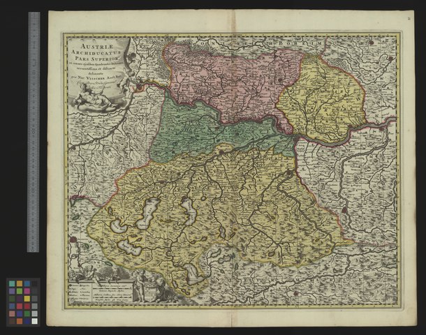
| Title |
Austriae archiducatus pars superior |
|||||||||||||||||||||||
| Description |
Austriae archiducatus pars superior : in omnes eiusdem quadrantes ditiones accuratissime et distincte delineata : cum privil. ordin. general. Belgii Foederati / per Nic. Visscher ; Kartuschenstecher: G. v. Gouwen schulp. |
|||||||||||||||||||||||
| Date | ||||||||||||||||||||||||
| Source | 10.3931/e-rara-13270 : Info: Kartenportal.CH | |||||||||||||||||||||||
| Creator |
Nicolaes Visscher Gilliam van der Gouwen |
|||||||||||||||||||||||
| Permission (Reusing this file) |
|
|||||||||||||||||||||||
| Geotemporal data | ||||||||||||||||||||||||
| Map location | Erzherzogtum Österreich / Oberösterreich | |||||||||||||||||||||||
| Scale | Ca. 1:340 000 | |||||||||||||||||||||||
| Bounding box |
|
|||||||||||||||||||||||
| Georeferencing | If inappropriate please set warp_status = skip to hide. | |||||||||||||||||||||||
| Bibliographic data | ||||||||||||||||||||||||
| Language | lat | |||||||||||||||||||||||
| Printed by |
Amst. Bat. Amsterdam, Nicolaes Visscher |
|||||||||||||||||||||||
| Archival data | ||||||||||||||||||||||||
| Collection |
|
|||||||||||||||||||||||
| Accession number |
Basel UB, Kartenslg Mappe 241:22 |
|||||||||||||||||||||||
| Dimensions | height: 46 cm (18.1 in); width: 56 cm (22 in) | |||||||||||||||||||||||
| Medium | Kupferdruck | |||||||||||||||||||||||
| Notes | Massstab in graph. Form (Milliaria Germanica coma., Milliaria Gallica sive Horae Itineris). - Titelkartusche oben links, Massstabskartusche unten links | |||||||||||||||||||||||


File history
Click on a date/time to view the file as it appeared at that time.
| Date/Time | Thumbnail | Dimensions | User | Comment | |
|---|---|---|---|---|---|
| current | 10:53, 25 August 2015 |  | 11,381 × 8,955, 2 pages (291.61 MB) | Basel University Library (talk | contribs) | GWToolset: Creating mediafile for Basel University Library. |
You cannot overwrite this file.
File usage on Commons
The following page uses this file: