File:1730 Homann Heirs Map of Belgium and Luxembourg - Geographicus - BelgiumCatholicum-hmhr-1747.jpg
Jump to navigation
Jump to search
Size of this preview: 698 × 599 pixels. Other resolutions: 280 × 240 pixels | 559 × 480 pixels | 895 × 768 pixels | 1,193 × 1,024 pixels | 2,385 × 2,048 pixels | 5,000 × 4,293 pixels.
Original file (5,000 × 4,293 pixels, file size: 8.66 MB, MIME type: image/jpeg)
Captions
Captions
Add a one-line explanation of what this file represents
| Artist |
|
|||||||||||||||||||||||
| Title |
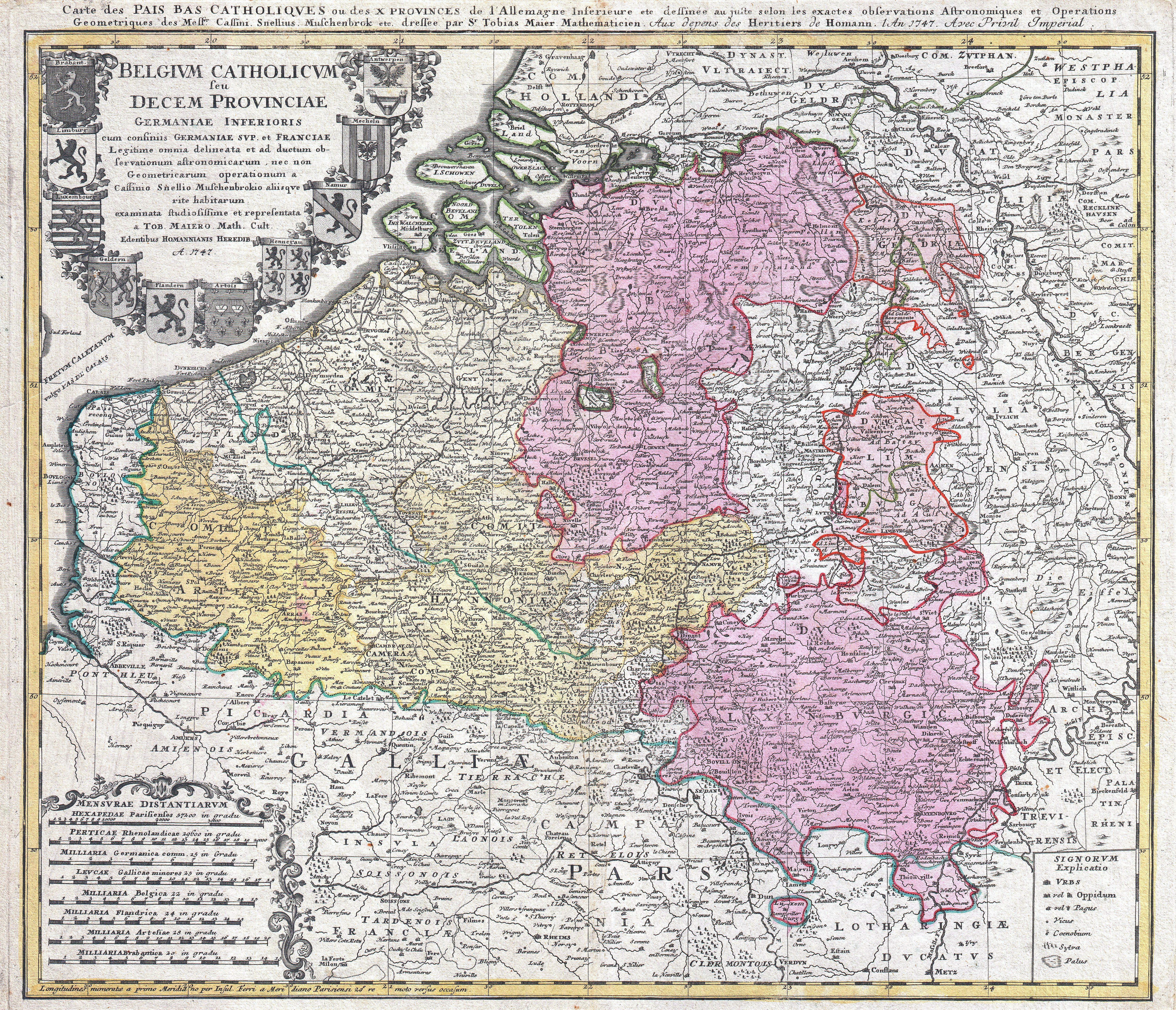
Belgium Catholicum seu Decem provinciae Germaniae Inferioris cum confiniis Germaniae sup. et Franciae… - Carte des Pais Bas Catholiques ou des X Provinces de l'Allemagne Inférieure etc.: legitime omnia delineata et ad ductum observationum astronomicarum, nec non geometricarum operationum a Cassinio, Snellio, Muschenbrokio aliisque rite habitarum, examinata studiosissime et representa a Tob. Maiero math. cult.: dessinée au juste selon les exactes observations astronomiques et operations geometriques de Messr. Cassini, Snellius, Muschenbrok etc. dressée par Sr. Tobias Maier |
|||||||||||||||||||||||
| Description |
English: A beautifully detailed c. 1730 J. B. Homann map of Belgium and Luxembourg. Depicts Belgium and Luxembourg as well as parts of Holland, France and Germany. The map notes fortified cities, villages, roads, bridges, forests, castles and topography. The title cartouche in the upper left quadrant features the 10 heraldic crests of the nations depicted. Alternative title in French in upper margin. This map was drawn in Nuremberg by Tobias Maier and included in the c. 1752 Homann Heirs Maior Atlas Scholasticus ex Triginta Sex Generalibus et Specialibus…. . |
|||||||||||||||||||||||
| Date | 1747 (dated) | |||||||||||||||||||||||
| Dimensions | height: 19.2 in (48.8 cm); width: 22 in (55.8 cm) | |||||||||||||||||||||||
| Accession number |
Geographicus link: BelgiumCatholicum-hmhr-1747 |
|||||||||||||||||||||||
| Source/Photographer |
Major Atlas Scholasticus Ex Triginta sex Generalibus et Specialibus Mappis Homannianis..., c. 1752.
|
|||||||||||||||||||||||
| Permission (Reusing this file) |
|
|||||||||||||||||||||||
.jpg)
File history
Click on a date/time to view the file as it appeared at that time.
| Date/Time | Thumbnail | Dimensions | User | Comment | |
|---|---|---|---|---|---|
| current | 07:51, 17 March 2011 | | 5,000 × 4,293 (8.66 MB) | BotMultichill (talk | contribs) | {{subst:User:Multichill/Geographicus |link=http://www.geographicus.com/P/AntiqueMap/BelgiumCatholicum-hmhr-1747 |product_name=1730 Homann Heirs Map of Belgium and Luxembourg |map_title=Belgium Catholicum seu Decem provinciae Germaniae Inferioris cum confi |
You cannot overwrite this file.
File usage on Commons
The following page uses this file:
File usage on other wikis
The following other wikis use this file:
- Usage on de.wikipedia.org
- Usage on es.wikipedia.org
- Usage on fr.wikipedia.org
- Usage on ro.wikipedia.org