File:Atoll forming-i18.png
Jump to navigation
Jump to search

Size of this preview: 412 × 599 pixels. Other resolutions: 165 × 240 pixels | 330 × 480 pixels | 528 × 768 pixels | 704 × 1,024 pixels | 1,667 × 2,423 pixels.
Original file (1,667 × 2,423 pixels, file size: 486 KB, MIME type: image/png)
Captions
Captions
Add a one-line explanation of what this file represents
Summary[edit]
| Description |
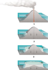
Internationalization of the diagram:Atoll forming. |
| Source | http://commons.wikimedia.org/wiki/Image:Atoll_forming.jpg |
| Author | Susan Mayfield and Sara Boore, modified by Eurico Zimbres |
| Permission (Reusing this file) |
Free for all use |
| Other versions |
Derivative works of this file: |
Licensing[edit]
This image is in the public domain in the United States because it only contains materials that originally came from the United States Geological Survey, an agency of the United States Department of the Interior. For more information, see the official USGS copyright policy.
|

|
This diagram image could be re-created using vector graphics as an SVG file. This has several advantages; see Commons:Media for cleanup for more information. If an SVG form of this image is available, please upload it and afterwards replace this template with
{{vector version available|new image name}}.
It is recommended to name the SVG file “Atoll forming-i18.svg”—then the template Vector version available (or Vva) does not need the new image name parameter. |
File history
Click on a date/time to view the file as it appeared at that time.
| Date/Time | Thumbnail | Dimensions | User | Comment | |
|---|---|---|---|---|---|
| current | 18:32, 29 May 2006 | | 1,667 × 2,423 (486 KB) | Zimbres (talk | contribs) | {{Information |Description= Internationalization of the diagram:Atoll forming.<br> '''1'''=Volcanic Island<br> '''2'''=Fringind reef<br> '''3'''=Barrier reeef<br> |Source=http://commons.wikimedia.org/wiki/Image:Atoll_forming.jpg |Date= |Author=USGS/USGov |
You cannot overwrite this file.
File usage on Commons
The following 8 pages use this file:
File usage on other wikis
The following other wikis use this file:
- Usage on az.wikipedia.org
- Usage on be-tarask.wikipedia.org
- Usage on be.wikipedia.org
- Usage on es.wikipedia.org
- Usage on eu.wikipedia.org
- Usage on fi.wikipedia.org
- Usage on ja.wikipedia.org
- Usage on kbd.wikipedia.org
- Usage on lt.wikipedia.org
- Usage on mdf.wikipedia.org
- Usage on nn.wikipedia.org
- Usage on pl.wikipedia.org
- Usage on ru.wikipedia.org
- Usage on ru.wiktionary.org
- Usage on uk.wikipedia.org
- Usage on www.wikidata.org