File:Blue Marble 2002.png

Tập tin gốc (43.200×21.600 điểm ảnh, kích thước tập tin: 529,58 MB, kiểu MIME: image/png)
Chú thích
Chú thích
Miêu tả
[sửa]| Cảnh báo | Một số trình duyệt có thể gặp trở ngại trong việc hiển thị hình này ở cỡ đầy đủ. Hình này có một số lượng điểm ảnh lớn và có thể không được tải chính xác hoặc làm trình duyệt bị treo. |
|---|
| Miêu tả |
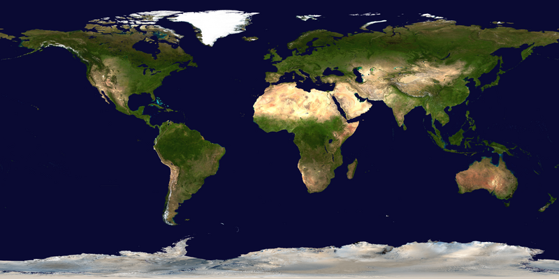
العربية: صور ساتليَّة مُجمَّعة لتُظهر سطح الأرض كاملًا.
English: This spectacular “blue marble” image is the most detailed true-color image of the entire Earth to date. Using a collection of satellite-based observations, scientists and visualizers stitched together months of observations of the land surface, oceans, sea ice, and clouds into a seamless, true-color mosaic of every square kilometer (.386 square mile) of our planet. These images are freely available to educators, scientists, museums, and the public.
Much of the information contained in this image came from a single remote-sensing device-NASA’s Moderate Resolution Imaging Spectroradiometer, or MODIS. Flying over 700 km above the Earth onboard the Terra satellite, MODIS provides an integrated tool for observing a variety of terrestrial, oceanic, and atmospheric features of the Earth. The land and coastal ocean portions of these images are based on surface observations collected from June through September 2001 and combined, or composited, every eight days to compensate for clouds that might block the sensor’s view of the surface on any single day. Two different types of ocean data were used in these images: shallow water true color data, and global ocean color (or chlorophyll) data. Topographic shading is based on the GTOPO 30 elevation dataset compiled by the U.S. Geological Survey’s EROS Data Center. MODIS observations of polar sea ice were combined with observations of Antarctica made by the National Oceanic and Atmospheric Administration’s AVHRR sensor—the Advanced Very High Resolution Radiometer. The cloud image is a composite of two days of imagery collected in visible light wavelengths and a third day of thermal infra-red imagery over the poles. Global city lights, derived from 9 months of observations from the Defense Meteorological Satellite Program, are superimposed on a darkened land surface map. |
| Ngày | |
| Nguồn gốc | NASA Visible Earth: Blue Marble: Land Surface, Shallow Water, and Shaded Topography |
| Tác giả | NASA’s Terra satellite for the MODIS imageries, combined by Meow. Credit: NASA Goddard Space Flight Center Image by Reto Stöckli (land surface, shallow water, clouds). Enhancements by Robert Simmon (ocean color, compositing, 3D globes, animation). Data and technical support: MODIS Land Group; MODIS Science Data Support Team; MODIS Atmosphere Group; MODIS Ocean Group Additional data: USGS EROS Data Center (topography); USGS Terrestrial Remote Sensing Flagstaff Field Center (Antarctica); Defense Meteorological Satellite Program (city lights). |
| Phiên bản khác |
|
.png)


Đánh giá
[sửa]
|
Giấy phép
[sửa]
| This file is in the public domain in the United States because it was solely created by NASA. NASA copyright policy states that "NASA material is not protected by copyright unless noted". (See Template:PD-USGov, NASA copyright policy page or JPL Image Use Policy.) | ||
 |
Warnings:
|
Lịch sử tập tin
Nhấn vào ngày/giờ để xem nội dung tập tin tại thời điểm đó.
| Ngày/Giờ | Hình xem trước | Kích cỡ | Thành viên | Miêu tả | |
|---|---|---|---|---|---|
| hiện tại | 10:34, ngày 23 tháng 7 năm 2023 | | 43.200×21.600 (529,58 MB) | Gioppolognomo (thảo luận | đóng góp) | Reverted to version as of 11:53, 5 August 2016 (UTC) |
| 10:28, ngày 23 tháng 7 năm 2023 |  | 5.400×2.700 (41,8 MB) | Gioppolognomo (thảo luận | đóng góp) | ||
| 11:53, ngày 5 tháng 8 năm 2016 |  | 43.200×21.600 (529,58 MB) | Meow (thảo luận | đóng góp) | c:User:Rillke/bigChunkedUpload.js: |
Bạn không được phép ghi đè tập tin này.
Trang sử dụng tập tin
21 trang sau sử dụng tập tin này:
- User:Yann/Featured images/2019-2023
- User:Yann/Featured pictures by others
- User talk:Meow/Archive 1
- Commons:Featured picture candidates/File:Blue Marble 2002.png
- Commons:Featured picture candidates/Log/October 2023
- Commons:Featured pictures/Places/Satellite images
- Commons:Featured pictures/chronological/2023-B
- Commons:Featured pictures/chronological/October 2023
- Commons:Picture of the Year/2023/Candidates
- Commons:Picture of the Year/2023/R1/Gallery/2023-B
- Commons:Picture of the Year/2023/R1/Gallery/ALL
- Commons:Picture of the Year/2023/R1/Gallery/Astronomy
- Commons:Picture of the Year/2023/R1/Gallery/M10
- Commons:Picture of the Year/2023/R1/v/Blue Marble 2002.png
- Commons:WikiProject Aviation/recent uploads/2016 August 5
- File:Blue Marble 2002.jpg
- File:Blue Marble 2002 (comparison).png
- File:Blue Marble 2002 bg21600.png
- File:MODIS Map.jpg
- File:Whole world - land and oceans.jpg
- File:Whole world - land and oceans 12000.jpg
Sử dụng tập tin toàn cục
Những wiki sau đang sử dụng tập tin này:
- Trang sử dụng tại ar.wikipedia.org
- Trang sử dụng tại bcl.wikipedia.org
- Trang sử dụng tại bn.wikipedia.org
- Trang sử dụng tại en.wikipedia.org
- Earth observation satellite
- World map
- Equirectangular projection
- Wikipedia:Featured pictures thumbs/04
- User talk:Nnfolz
- Wikipedia:Featured pictures/Space/Looking back
- Talk:Fishing vessel
- User:Huggums537
- Template talk:GeoTemplate/Archive 15
- Wikipedia:Featured picture candidates/delist/2020
- Wikipedia:Featured picture candidates/delist/Blue Marble
- User:GTAVCV20022013
- User:Hurricane Noah/TCMap/Current
- User:Hurricane Noah/TCMap
- User:Hurricane Noah/TCMap/Maps
- User talk:HighInBC/Archive 83
- User:LoekVV
- Portal:World
- Wikipedia:Picture of the day/January 2023
- User:SuperPentagonAnimations/sandbox
- Wikipedia talk:WikiProject Weather/Colour discussions
- Template:POTD/2023-01-11
- Wikipedia:Main Page history/2023 January 11
- Wikipedia:Main Page history/2023 January 11b
- Trang sử dụng tại en.wikibooks.org
- Trang sử dụng tại fa.wikipedia.org
- Trang sử dụng tại fr.wikipedia.org
- Trang sử dụng tại ha.wikipedia.org
- Trang sử dụng tại he.wikipedia.org
- Trang sử dụng tại it.wikibooks.org
- Trang sử dụng tại mk.wikipedia.org
- Trang sử dụng tại pnb.wikipedia.org
- Trang sử dụng tại th.wikipedia.org
- Trang sử dụng tại tr.wikipedia.org
- Trang sử dụng tại tum.wikipedia.org
- Trang sử dụng tại tw.wikipedia.org
- Trang sử dụng tại ur.wikipedia.org
- Trang sử dụng tại vi.wikipedia.org