File:British Isles.svg
Vai alla navigazione
Vai alla ricerca

Dimensioni di questa anteprima PNG per questo file SVG: 361 × 600 pixel. Altre risoluzioni: 144 × 240 pixel | 289 × 480 pixel | 462 × 768 pixel | 616 × 1 024 pixel | 1 232 × 2 048 pixel | 1 300 × 2 160 pixel.
File originale (file in formato SVG, dimensioni nominali 1 300 × 2 160 pixel, dimensione del file: 154 KB)
Didascalie
Didascalie
Aggiungi una brevissima spiegazione di ciò che questo file rappresenta
Dettagli[modifica]
| Descrizione |
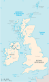
An SVG map of the British Isles, with the largest islands and archipelagos labelled. Always considered part of the British Isles
Sometimes considered part of the British Isles
Other lands |
| Fonte | Opera propria |
| Autore | Smurrayinchester |
| SVG sviluppo | Il codice sorgente di questo file SVG non è valido a causa di 51 errori. Questa mappa in grafica vettoriale non valida secondo il W3C è stata creata con un programma SVG ignoto. This map is translated using SVG switch elements: all translations are stored in the same file. |
}
Licenza[modifica]
Io, detentore del copyright su quest'opera, dichiaro di pubblicarla con la seguente licenza:

|
È permesso copiare, distribuire e/o modificare questo documento in base ai termini della GNU Free Documentation License, Versione 1.2 o successive pubblicata dalla Free Software Foundation; senza alcuna sezione non modificabile, senza testo di copertina e senza testo di quarta di copertina. Una copia della licenza è inclusa nella sezione intitolata Testo della GNU Free Documentation License. |
| Questo file è disponibile in base alla licenza Creative Commons Attribuzione-Condividi allo stesso modo 3.0 Unported | ||
| ||
| Questo tag di copyright è stato aggiunto nell'ambito dell'aggiornamento della licenza dei progetti Wikimedia. |
Derivative works[modifica]
-
 македонски
 -
 Flag map (1801–1922)


derivative works[modifica]
Opere derivate da questo file: British Isles mk.svg
Cronologia del file
Fare clic su un gruppo data/ora per vedere il file come si presentava nel momento indicato.
| Data/Ora | Miniatura | Dimensioni | Utente | Commento | |
|---|---|---|---|---|---|
| attuale | 15:33, 10 feb 2019 | | 1 300 × 2 160 (154 KB) | MSG17 (discussione | contributi) | Uploaded from SVG Translate. |
| 14:56, 13 ott 2018 |  | 1 300 × 2 160 (141 KB) | Seb35 (discussione | contributi) | small bug: translations have to be before the default text else the PNG rendering selects the default text | |
| 14:51, 13 ott 2018 |  | 1 300 × 2 160 (141 KB) | Seb35 (discussione | contributi) | added French translation | |
| 14:50, 20 mag 2014 |  | 1 300 × 2 160 (135 KB) | NikNaks (discussione | contributi) | More cleaning. File could still be a lot smaller than it currently is | |
| 03:02, 20 mag 2014 |  | 1 300 × 2 160 (152 KB) | NikNaks (discussione | contributi) | Malay translation | |
| 02:36, 20 mag 2014 |  | 1 300 × 2 160 (148 KB) | NikNaks (discussione | contributi) | Cleaning unfortunately lost detail. Will have to return to later | |
| 02:22, 20 mag 2014 |  | 1 297 × 2 160 (37 KB) | NikNaks (discussione | contributi) | Attempting to clean up the file before translation | |
| 12:37, 20 ago 2006 |  | 1 297 × 2 160 (196 KB) | Smurrayinchester (discussione | contributi) | An SVG map of the British Isles, with the largest islands and archipelagos labeled. {{legend|#fff0de|Always considered part of the British Isles|border=#ffffff}} {{legend|#ffb380|Sometimes considered part of the British Isles|border=#ffffff}} {{legend|#e |
Impossibile sovrascrivere questo file.
Utilizzo del file
Le seguenti 4 pagine usano questo file:
Utilizzo globale del file
Anche i seguenti wiki usano questo file:
- Usato nelle seguenti pagine di ar.wikipedia.org:
- Usato nelle seguenti pagine di az.wikipedia.org:
- Usato nelle seguenti pagine di be.wikipedia.org:
- Usato nelle seguenti pagine di bs.wikipedia.org:
- Usato nelle seguenti pagine di ceb.wikipedia.org:
- Usato nelle seguenti pagine di ckb.wikipedia.org:
- Usato nelle seguenti pagine di da.wikipedia.org:
- Usato nelle seguenti pagine di en.wikipedia.org:
- Geography of the Isle of Man
- Burhou
- Talk:International Football Association Board
- Module:Location map/data/British Isles/doc
- List of offshore wind farms in the Irish Sea
- Siege of St Andrews Castle
- User:Malpass93/sandbox
- Module:Location map/data/British Isles
- 2014 Senior Open Championship
- 2017 Senior Open Championship
- 2018 Eisenhower Trophy
- User:Grover cleveland/History of the laws of the game/List of IFAB meetings
- User:Grover cleveland/English managers
- 2018 Espirito Santo Trophy
- 1965 European Amateur Team Championship
- 1975 European Amateur Team Championship
- 1981 European Amateur Team Championship
- 1989 European Amateur Team Championship
- 1997 European Amateur Team Championship
- 2005 European Amateur Team Championship
- 2007 European Amateur Team Championship
- 2009 European Amateur Team Championship
- 1971 European Ladies' Team Championship
- 1979 European Ladies' Team Championship
- 1987 European Ladies' Team Championship
- 1991 European Ladies' Team Championship
- 2013 European Ladies' Team Championship
- 2021 European Ladies' Team Championship
- 2022 European Amateur Team Championship
- 2022 European Ladies' Team Championship
- 2013 Senior Open Championship
- 2012 Senior Open Championship
- 2011 Senior Open Championship
- 2008 Senior Open Championship
- 2006 Senior Open Championship
- 2002 Senior British Open
- 2001 Senior British Open
- 2000 Senior British Open
- 2022 Senior Open Championship
- User:Erik Sergeant/sandbox 2
- 2023 Senior Open Championship
- Module:Location map/data/British Isles/sandbox
- Draft:2024 Monoposto Championship
Visualizza l'utilizzo globale di questo file.