File:Central europe 1683.png
Bước tới điều hướng
Bước tới tìm kiếm

Kích thước hình xem trước: 790×599 điểm ảnh. Độ phân giải khác: 317×240 điểm ảnh | 633×480 điểm ảnh | 1.013×768 điểm ảnh | 1.280×971 điểm ảnh.
Tập tin gốc (1.280×971 điểm ảnh, kích thước tập tin: 406 kB, kiểu MIME: image/png)
Chú thích
Chú thích
Ghi một dòng giải thích những gì có trong tập tin này
Miêu tả[sửa]
| Miêu tả |
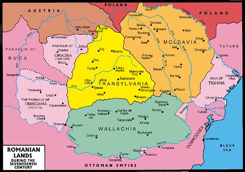
English: Central Europe during the short-term existence of Imre Thököly's Principality of Upper Hungary. - Habsburg and Ottoman territories, including Habsburg Kingdom of Hungary (Royal Hungary) and Habsburg Croatia, Ottoman vassal states (Wallachia, Moldavia, Transylvania, Principality of Upper Hungary (existed between 1682-1685), Montenegro, Ragusa) and Ottoman eyalets. The Ottoman expansion was asked by prince Imre Thököly in Upper Hungary (centered in present-day Slovakia) against the Habsburgs. The Ottoman Rule in Upper Hungary lasted only for 3 years. |
| Ngày | |
| Nguồn gốc | Tác phẩm được tạo bởi người tải lên |
| Tác giả | PANONIAN |
| Phiên bản khác |
Derivative works of this file:
|
Giấy phép[sửa]
Tôi, người giữ bản quyền tác phẩm này, từ đây phát hành nó theo giấy phép sau:
| Tập tin này được phân phối theo Creative Commons Hiến tặng vào Phạm vi Công cộng Toàn thế giới CC0. | |
| Người nào gán tài liệu này với tác phẩm nghĩa là đã hiến tác phẩm cho phạm vi công cộng bằng cách từ bỏ mọi quyền lợi của người đó đối với tác phẩm theo quy định của luật bản quyền, có hiệu lực trên toàn thế giới và các quyền lợi pháp lý phụ mà người đó có được trong tác phẩm, đến mức độ mà luật pháp cho phép. Bạn được tự do sao chép, phân phối, và biểu diễn tác phẩm này, tất cả đều không bắt buộc ghi công.
|
References[sửa]
- The Times History of Europe, Times Books, London, 2002.
- Peter Rokai - Zoltan Đere - Tibor Pal - Aleksandar Kasaš, Istorija Mađara, Beograd, 2002.
- Dr Dušan J. Popović, Srbi u Vojvodini, knjiga 1, Novi Sad, 1990.
- Dr D. J. Popović, Vojvodina u tursko doba, Zbornik "Vojvodina", knjiga I, Fototipsko izdanje, PROMETEJ, Novi Sad, 2008.
- Halil Inaldžik, Osmansko carstvo, Beograd, 2003.
- Petrit Imami, Srbi i Albanci kroz vekove, Beograd, 2000.
- File:Magyar- és Erdélyország 1629-ben (Pallas).jpg
- http://www.sulinet.hu/oroksegtar/data/telepulesek_ertekei/Erd/pages/images/221.jpg
- http://www.zum.de/whkmla/region/balkans/xsilistra.html
- http://www.euratlas.net/history/europe/1600/index.html
- http://www.freeweb.hu/csodaszarvas/galeria/galeria09/001/large_terkep12.jpg
- http://mek.niif.hu/01800/01885/html/cd5m/kepek/tortenelem/to212pe94185.jpg
- http://www.tortenelemklub.hu/galeries/6/Wesselényi%20legújabb.JPG[dead link]
- http://farm4.static.flickr.com/3361/3657063110_1532418eb3.jpg
- http://www.camo.ch/Images/bpasaluk06.jpg archive copy at the Wayback Machine
- http://medlem.spray.se/zelenika/sandzak.jpg[dead link]
- http://img375.imageshack.us/img375/7287/pasaluk2.png
- http://www.camo.ch/Images3/bhpasaluk.jpg archive copy at the Wayback Machine
- http://xxlworld.xx.ohost.de/povijest/slike/mape/1606.jpg
- http://www.hic.hr/books/pavlicev/images/s05.gif archive copy at the Wayback Machine
- http://api.wb21.net/images/a-torok-hodoltsag-kora-magyar-tortenelem/dr-blaskovics-jozsef,az-ujvari-ejalet-torok-adoosszeirasai.jpg archive copy at the Wayback Machine
.jpg)
Lịch sử tập tin
Nhấn vào ngày/giờ để xem nội dung tập tin tại thời điểm đó.
| Ngày/Giờ | Hình xem trước | Kích cỡ | Thành viên | Miêu tả | |
|---|---|---|---|---|---|
| hiện tại | 12:48, ngày 31 tháng 1 năm 2020 | | 1.280×971 (406 kB) | Claude Zygiel (thảo luận | đóng góp) | Belergad eyalet cited in: Artin Hindoğlu's "Kurzwörterbuch Türkisch-Deutsch / Dictionnaire abrégé Turc-Français", Wien 1838, p. 125. |
| 21:35, ngày 8 tháng 4 năm 2018 |  | 1.280×971 (390 kB) | Filederchest (thảo luận | đóng góp) | info | |
| 19:06, ngày 8 tháng 4 năm 2018 |  | 1.280×971 (378 kB) | Filederchest (thảo luận | đóng góp) | Principality of Upper Hungary | |
| 15:19, ngày 28 tháng 1 năm 2017 |  | 1.543×1.170 (146 kB) | PANONIAN (thảo luận | đóng góp) | Reverted to version as of 20:47, 8 September 2011 (UTC) - this shows vassal principalities as separate states which they were not | |
| 20:52, ngày 25 tháng 1 năm 2017 |  | 1.543×1.170 (135 kB) | Mélomène (thảo luận | đóng góp) | Contrast | |
| 20:47, ngày 8 tháng 9 năm 2011 |  | 1.543×1.170 (146 kB) | PANONIAN (thảo luận | đóng góp) | corrected version | |
| 16:59, ngày 5 tháng 9 năm 2011 |  | 1.543×1.170 (143 kB) | PANONIAN (thảo luận | đóng góp) | {{Information |Description ={{en|1=Central Europe in 1683.}} |Source ={{own}} |Author =PANONIAN |Date =2011 |Permission = |other_versions = }} |
Bạn không được phép ghi đè tập tin này.
Trang sử dụng tập tin
13 trang sau sử dụng tập tin này:
- Atlas of Bosnia and Herzegovina
- Atlas of Croatia
- Atlas of Hungary
- Atlas of Moldova
- Atlas of Romania
- Atlas of Slovakia
- Atlas of Transylvania
- Atlas of Vojvodina
- User:J budissin/Uploads/BiH/2017 January 21-31
- User:J budissin/Uploads/BiH/2018 April 1-10
- User:J budissin/Uploads/BiH/2020 January 21-31
- Commons:Graphic Lab/Map workshop/Archive/2014
- Category:Budin Province, Ottoman Empire
Sử dụng tập tin toàn cục
Những wiki sau đang sử dụng tập tin này:
- Trang sử dụng tại an.wikipedia.org
- Trang sử dụng tại ar.wikipedia.org
- Trang sử dụng tại arz.wikipedia.org
- Trang sử dụng tại azb.wikipedia.org
- Trang sử dụng tại az.wikipedia.org
- Trang sử dụng tại ba.wikipedia.org
- Trang sử dụng tại be-tarask.wikipedia.org
- Trang sử dụng tại be.wikipedia.org
- Trang sử dụng tại bg.wikipedia.org
- Trang sử dụng tại bn.wikipedia.org
- Trang sử dụng tại bs.wikipedia.org
- Trang sử dụng tại ca.wikipedia.org
- Trang sử dụng tại cs.wikipedia.org
- Trang sử dụng tại de.wikipedia.org
- Trang sử dụng tại el.wikipedia.org
- Trang sử dụng tại en.wikipedia.org
Xem thêm các trang toàn cục sử dụng tập tin này.
Đặc tính hình
Thể loại:
- Maps of the history of Central Europe
- Maps of the Habsburg Monarchy
- Maps of eyalets of the Ottoman Empire
- Maps of vassal states of the Ottoman Empire
- Maps of the history of the Ottoman Empire in the 1680s
- Maps of the history of Hungary (1526–1700)
- Maps of the history of Slovakia
- Maps of the history of Croatia (1526–1918)
- Maps of the history of Bosnia and Herzegovina under Ottoman Empire
- Maps of the Ottoman period in the history of Serbia
- Maps of the history of Vojvodina
- Maps of the history of Banat
- Maps of the history of Early Modern Romania
- Maps of the history of Transylvania
- Maps of the history of Moldova
- Kingdom of Hungary (1526–1867)
- Principality of Upper Hungary
- Eyalet of Bosnia
- Budin Province, Ottoman Empire
- Kanije Province, Ottoman Empire
- Eğri Province, Ottoman Empire
- Maps of Temeşvar Province, Ottoman Empire
- Varat Province, Ottoman Empire
- Uyvar Province, Ottoman Empire
- Principality of Transylvania
- Maps of Wallachia
- Maps of the Principality of Moldavia
- Romania in the 17th century
- 1683
- 1683 in Europe
- 1683 in Romania