File:Post Roman Balkans.jpg

Original file (2,038 × 1,677 pixels, file size: 721 KB, MIME type: image/jpeg)
Captions
Captions
Bilindik köyü
Summary
[edit]| DescriptionPost Roman Balkans.jpg |
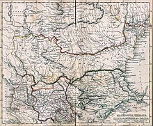
Macedonia, Thracia, Illyria, Moesia, Dacia,(Map X),"Comment on Map from author; Map X., & c. - Although most portions of this map are well represented, still we have a deficiency in the classical portion, as it has not been yet sufficiently examined by those who are capable of deciding and systematizing the comparative geography."
|
|||||
| Date | ||||||
| Source | A classical atlas, to illustrate ancient geography: comprised in twenty-five maps, showing the various divisions of the world as known to the ancients : composed from the most authentic sources with an index of the ancient and modern names,Alexander G. Findlay,Publisher;Harper,1849 | |||||
| Author | Alexander G. Findlay | |||||
| Permission (Reusing this file) |
|
|||||
| Other versions |
   |
|||||
File history
Click on a date/time to view the file as it appeared at that time.
| Date/Time | Thumbnail | Dimensions | User | Comment | |
|---|---|---|---|---|---|
| current | 18:49, 28 January 2010 |  | 2,038 × 1,677 (721 KB) | WikiEditor2004 (talk | contribs) | Reverted to version as of 01:28, 27 March 2005 - restored original version which has more historical value. please upload your whitened version as a new separate file, not over this one, thank you |
| 10:02, 17 May 2009 |  | 2,038 × 1,677 (1.1 MB) | Alex:D (talk | contribs) | whitened | |
| 01:28, 27 March 2005 |  | 2,038 × 1,677 (721 KB) | Karmosin~commonswiki (talk | contribs) | Classical Balkans: from ''Map from "rothers Publishers, New York, 1849A Classical Atlas to Illustrate Ancient Geography,'' Alexander G. Findlay, Harper and B ros. NY 1849 {{PD-art}} category:History of the Balkans |
You cannot overwrite this file.
File usage on Commons
The following 16 pages use this file:
- Ancient Thrace and ancient Thracians
- Atlas of Albania
- Atlas of Bulgaria
- Atlas of European history
- Atlas of Romania
- Atlas of Transylvania
- Atlas of the antiquity
- Dacia and Dacians
- Illyria and Illyrians
- Komotini
- User:Alex:D/Project2
- File:ClassicalBalkans1849.jpg (file redirect)
- File:Egumenoski 's Map of the Balkans.jpg (file redirect)
- File:Macedonia-Thracia-Illyria-Moesia-Dacia1849.jpg
- File:Macedonia-Thracia-Illyria-Moesia-Dacia1849refurbished.jpg
- File:Roman Empire Map AlexanderFindlay1849.png
File usage on other wikis
The following other wikis use this file:
- Usage on ar.wikipedia.org
- Usage on arz.wikipedia.org
- Usage on azb.wikipedia.org
- Usage on az.wikipedia.org
- Usage on ba.wikipedia.org
- Usage on be-tarask.wikipedia.org
- Usage on be.wikipedia.org
- Usage on bg.wikipedia.org
- Usage on ca.wikipedia.org
- Usage on cs.wikipedia.org
- Usage on en.wikipedia.org
- Usage on eo.wikipedia.org
- Usage on es.wikipedia.org
- Usage on gl.wikipedia.org
- Usage on he.wikipedia.org
- Usage on hr.wikipedia.org
- Usage on hy.wikipedia.org
- Usage on it.wikipedia.org
- Usage on ja.wikipedia.org
- Usage on mk.wikipedia.org
- Usage on nl.wikipedia.org
- Usage on pt.wikipedia.org
- Usage on ro.wikipedia.org
- Usage on ru.wikipedia.org
- Usage on sv.wikipedia.org
View more global usage of this file.
Metadata
This file contains additional information such as Exif metadata which may have been added by the digital camera, scanner, or software program used to create or digitize it. If the file has been modified from its original state, some details such as the timestamp may not fully reflect those of the original file. The timestamp is only as accurate as the clock in the camera, and it may be completely wrong.
| JPEG file comment | File written by Adobe Photoshop¨ 4.0 |
|---|
- Maps of the history of the ancient Balkans
- Old maps of the Balkans
- Maps of the history of Kosovo in ancient times
- Old maps of the Danube watercourse system
- Maps of the lower Danube
- Maps of the middle Danube
- Roman Macedonia
- Roman Thrace
- Moesia Superior
- Moesia Inferior
- Maps of Dacia
- Maps of Illyricum
- Iazyges
- A classical atlas, to illustrate ancient geography (1857)