File:Etruskische beschaving.svg

File originale (file in formato SVG, dimensioni nominali 1 500 × 1 820 pixel, dimensione del file: 540 KB)
Didascalie
Didascalie
Dettagli
[modifica]| DescrizioneEtruskische beschaving.svg |
[modifica]
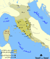
Català: Un mapa que mostra l'extensió d'Etruria i la civilització etrusca. El mapa inclou les 12 ciutats de la Lliga Etrusca i ciutats notables fundades pels etruscs. Les dates del mapa són una aproximació. English: A map showing the extent of Etruria and the Etruscan civilization. The map includes the 12 cities of the Etruscan League and notable cities founded by the Etruscans. The dates on the map are an approximation. Español: Expansión etrusca entre el 750 y el 500 a. de C., las ciudades de la Liga etrusca y otras notables fundadas por los etruscos. Português: Mapa da expansão etrusca entre 750-500 Suomi: Kartta Etruriasta ja etruskien sivilisaatiosta sen ollessa laajimmillaan. Karttaan on merkitty etruskien kaupunkiliiton 12 kaupunkia sekä muita etruskien perustamia merkittäviä kaupunkeja. Ελληνικά: Χάρτης της Ετρουρίας Беларуская: Карта паказвае абрысы Этрурыі і этрускай цывілізацыі. Яна ўключае 12 асноўных гарадоў этрускай лігі і іншыя горады, заснаваныя этрускамі. ქართული: ეტრუსკული ცივილიზაციის რუკა. עברית : מפה המציגה את היקף אטרוריה והציוויליזציה האטרוסקית. המפה כוללת את 12 ערי הליגה האטרוסקית וערים בולטות שנוסדו על ידי האטרוסקים. התאריכים במפה הם בקירוב. العربية : خريطة تُظهر نطاق الحضارتين الإترورياويَّة والإتروسكانيَّة. تتضمَّن هذه الخريطة 12 مدينة انتمت إلى الرابطة الإتروسكانيَّة ومُدن مُهمَّة وبارزة أُخرى كانت قائمة ضمن بلاد الإتروسكان. |
||
| Data | 2005-07-26, Blank uploaded 2006-02-27. | ||
| Fonte | Opera propria | ||
| Autore | NormanEinstein (translated by Evil berry) | ||
| Licenza (Riusare questo file) |
GNU FDL | ||
| Altre versioni |
File:Etruskische beschaving.svg has 2 translations.
Other related versions:[modifica]
|
Questo file SVG contiene del testo che può essere facilmente tradotto nella tua lingua, utilizzando un editor che supporta SVG (ad esempio un editor XML o di testo). Per maggiori informazioni vedi: Tradurre un file SVG. |
This file is translated using SVG For most Wikipedia projects, you can embed the file normally (without a To translate the text into your language, you can use the SVG Translate tool. Alternatively, you can download the file to your computer, add your translations using whatever software you're familiar with, and re-upload it with the same name. You will find help in Graphics Lab if you're not sure how to do this. |
Licenza
[modifica]
|
È permesso copiare, distribuire e/o modificare questo documento in base ai termini della GNU Free Documentation License, Versione 1.2 o successive pubblicata dalla Free Software Foundation; senza alcuna sezione non modificabile, senza testo di copertina e senza testo di quarta di copertina. Una copia della licenza è inclusa nella sezione intitolata Testo della GNU Free Documentation License.http://www.gnu.org/copyleft/fdl.htmlGFDLGNU Free Documentation Licensetruetrue |
| Questo file è disponibile in base alla licenza Creative Commons Attribuzione-Condividi allo stesso modo 3.0 Unported | ||
| ||
| Questo tag di copyright è stato aggiunto nell'ambito dell'aggiornamento della licenza dei progetti Wikimedia.http://creativecommons.org/licenses/by-sa/3.0/CC BY-SA 3.0Creative Commons Attribution-Share Alike 3.0truetrue |
Cronologia del file
Fare clic su un gruppo data/ora per vedere il file come si presentava nel momento indicato.
| Data/Ora | Miniatura | Dimensioni | Utente | Commento | |
|---|---|---|---|---|---|
| attuale | 02:39, 19 mar 2022 |  | 1 500 × 1 820 (540 KB) | Manlleus (discussione | contributi) | File uploaded using svgtranslate tool (https://svgtranslate.toolforge.org/). Added translation for ca. |
| 11:57, 28 ott 2010 |  | 1 500 × 1 820 (522 KB) | Perhelion (discussione | contributi) | font resizing | |
| 11:08, 28 ott 2010 |  | 1 500 × 1 821 (525 KB) | Perhelion (discussione | contributi) | embed blank png map, fix text | |
| 17:38, 30 giu 2010 |  | 1 500 × 1 821 (17 KB) | DieBuche (discussione | contributi) | Try to fix SVG using scour | |
| 15:14, 9 nov 2008 |  | 1 500 × 1 821 (37 KB) | Evil berry (discussione | contributi) | {{Information |Description= |Source= |Date= |Author= |Permission= |other_versions= }} | |
| 15:12, 9 nov 2008 |  | 1 500 × 1 821 (37 KB) | Evil berry (discussione | contributi) | ||
| 14:58, 10 gen 2008 |  | 1 500 × 1 821 (36 KB) | Evil berry (discussione | contributi) | ||
| 14:54, 10 gen 2008 |  | 1 500 × 1 821 (37 KB) | Evil berry (discussione | contributi) | == Description == {{Information| |Description={{en|Dutch version of a map showing the extent of Etruria and the Etruscan civilization. The map includes the 12 cities of the Etruscan League and notable cities founded by the Etruscans.}} |Source=own work. | |
Impossibile sovrascrivere questo file.
Utilizzo del file
Le seguenti 19 pagine usano questo file:
- User:Magog the Ogre/Multilingual legend/2022 March 11-20
- File:Civilizacion etrusca.png
- File:Etruscan civilization HE.png
- File:Etruscan civilization blank map.png
- File:Etruscan civilization georgian map.png
- File:Etruscan civilization italian map.png
- File:Etruscan civilization map-ar.png
- File:Etruscan civilization map-be.png
- File:Etruscan civilization map-de.png
- File:Etruscan civilization map-el.png
- File:Etruscan civilization map-fi.png
- File:Etruscan civilization map.png
- File:Etruscan civilization map ua.PNG
- File:Etruskische beschaving.png
- File:Etruskische beschaving.svg
- File:Expansão etrusca-es.svg
- File:Expansão etrusca-pt.svg
- File:Étrurie.png
- Template:Other versions/Etruscan civilization map
Utilizzo globale del file
Anche i seguenti wiki usano questo file:
- Usato nelle seguenti pagine di ca.wikipedia.org:
- Usato nelle seguenti pagine di eo.wikipedia.org:
- Usato nelle seguenti pagine di ia.wikipedia.org:
- Usato nelle seguenti pagine di www.wikidata.org:
Metadati
Questo file contiene informazioni aggiuntive, probabilmente aggiunte dalla fotocamera o dallo scanner usati per crearlo o digitalizzarlo. Se il file è stato modificato, alcuni dettagli potrebbero non corrispondere alla realtà.
| Larghezza | 1500 |
|---|---|
| Altezza | 1820 |


