File:Holy Roman Empire 1648.svg

Pradinė rinkmena (SVG rinkmena, formaliai 2 283 × 1 810 taškų, rinkmenos dydis: 3,07 MiB)
Captions
Captions
Aprašymas
[keisti]| Aprašymas |
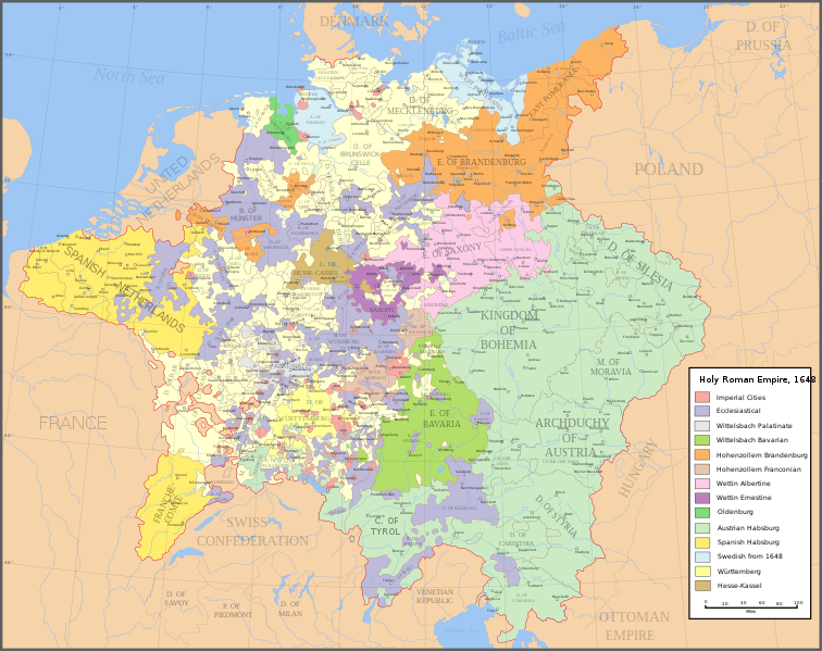
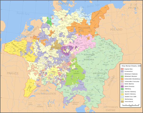
English: Map of the Holy Roman Empire in 1648, after the Peace of Westphalia which ended the Thirty Years' War. Deutsch: Karte des Heiligen Römischen Reiches 1648, nach dem Westfälischer Friede, der den Dreißigjähriger Krieg beendete. Français : Carte du Saint-Empire à 1648, après la paix de Westphalie qui mettent fin à la guerre de Trente Ans. Version française est disponible à File:Holy Roman Empire 1648 fr.svg. Српски / srpski: Мапа Светог римског царства у 1648, након Вестфалског мира којим је завршен Тридесетогодишњи рат.
|
English | Deutsch | Français | Српски |
||
|---|---|---|---|---|---|
| A | Archbishopric | Erzbistum | Archevêché | АДИЈ. | Архидијецеза |
| B | Bishopric | Bistum | Évêché | ДИЈ. | Дијецеза |
| C | County | Grafschaft | Comté | ОКР./ГРОФ. | Округ/грофовија |
| D | Duchy | Herzogtum | Duché | ВОЈВ. | Војводство |
| E | Electorate | Kurfürstentum | Électorat | ЕЛЕКТ. | Електорат |
| L | Landgraviate | Landgrafschaft | Landgraviat | ЛГРОФ. | Ландгрофовија |
| M | Margraviate | Markgrafschaft | Margraviat | МГРОФ. | Маркгрофовија |
| P | Principality | Fürstentum | Principauté | ГРОФ./ОКР. | Грофовија/округ |
Legend / Farblegende / Légende / Легенда
English | Deutsch | Français | Српски |
|
|---|---|---|---|---|
Palatinat des Wittelsbach |
||||
Wittelsbach Bavaria |
Wittelsbacher Bayern |
Bavière des Wittelsbach |
Вителсбах, баварски | |
Hohenzollern Franconia |
Hohenzollerner Franken |
Хоенцолерн, франконски | ||
Wettin Ernestine Saxony |
Wettiner Ernestiner Sachsen |
Saxe de la branche ernestine des Wettin |
Ветин, ернестински | |
Made from the public domain map "Central Europe about 1648" from the Historical Atlas by William R. Shepherd, at the Perry-Castañeda Library Map Collection at the University of Texas. Further information from Overy, Richard, 2006, The Times Complete history of the world Times Books ISBN 0007181299, and from this map
See also other maps at external links:
- Central Europe 1648
- Map on personal site, Europe in 1648
- Treaty of Westphalia
- 1648 map of Prussia
- Britannica, Spanish domains in 1648
(Šios rinkmenos panaudojimas kitur)

|
Suteikiamas leidimas kopijuoti, platinti ir/ar redaguoti šį dokumentą pagal GNU Free Documentation licencijos versijos 1.2 ar bet kurios vėlesnės versijos sąlygas, publikuotas Free Software Foundation; be nekintamų dalių, be priekinių ir galinių tekstinių žymų viršeliuose. Šios licencijos kopija įtraukta dalyje, pavadintoje GNU Free Documentation License. |
| Šiam failui taikoma Creative Commons Attribution-Share Alike 3.0 Unported licencija. | ||
| ||
| Licencijos šablonas buvo priskirtas šiam failui kaip GFDL licencijos atnaujinimo dalis. |
[]
-
 anglų SVG
 -
 ispanų SVG
 -
 prancūzų SVG
 -
 gruzinų SVG
 -
 serbų SVG
 -
 English: Blank PNG
 -
 anglų PNG
 -
 ispanų PNG
 -
 serbų PNG
 -
 rusų PNG


|
Šiame SVG faile yra išverstas įterptasis tekstas. Šį tekstą galite išversti ir į savo kalbą, naudodami SVG vertimo įrankį ar kitus SVG redaktorius. Daugiau informacijos rasite apsilankę: Apie SVG failų vertimą. |
Rinkmenos istorija
Paspauskite ant datos/laiko, kad pamatytumėte rinkmeną tokią, kokia ji buvo tuo metu.
| Data/Laikas | Miniatiūra | Matmenys | Naudotojas | Paaiškinimas | |
|---|---|---|---|---|---|
| dabartinis | 20:43, 24 liepos 2022 | | 2 283 × 1 810 (3,07 MiB) | Maproom (aptarimas | indėlis) | ZWEIBRCKEN -> ZWEIBRÜCKEN, Treves -> Trier, Liege -> Liège |
| 17:55, 18 gegužės 2022 |  | 2 283 × 1 810 (3,07 MiB) | Maproom (aptarimas | indėlis) | Consistent, and German, spelling of "Mainz" | |
| 20:11, 25 gegužės 2021 |  | 2 283 × 1 810 (3,07 MiB) | ElCet (aptarimas | indėlis) | added the biggest city of Upper Silesia back then | |
| 11:34, 23 kovo 2018 |  | 2 283 × 1 810 (3,01 MiB) | Valentinian (aptarimas | indėlis) | Cleanup some names including missing umlauts. Brunswick-Lüneburg -> Brunswick-Celle (see talk). Border north of Rendsburg seems slightly off to me and the situation in Holstein is rather simplified (jointly administered areas are missing). | |
| 19:09, 8 spalio 2010 |  | 2 283 × 1 810 (3,01 MiB) | Joostik (aptarimas | indėlis) | Ravenstein as part of Cleves | |
| 19:45, 9 rugpjūčio 2009 |  | 2 283 × 1 810 (3,01 MiB) | Ysangkok (aptarimas | indėlis) | simplify code (save as plain svg) | |
| 09:24, 14 liepos 2009 |  | 2 283 × 1 810 (4,17 MiB) | Roke~commonswiki (aptarimas | indėlis) | Zusmarshausen | |
| 15:16, 20 balandžio 2007 |  | 2 283 × 1 810 (4,12 MiB) | Roke~commonswiki (aptarimas | indėlis) | ||
| 02:04, 20 balandžio 2007 |  | 2 283 × 1 810 (4,11 MiB) | Roke~commonswiki (aptarimas | indėlis) | rm HRE text, darken labels | |
| 03:04, 18 balandžio 2007 |  | 2 283 × 1 810 (4,11 MiB) | Roke~commonswiki (aptarimas | indėlis) |
Jūs negalite perrašyti šios rinkmenos.
Rinkmenos naudojimas
Šie puslapiai naudoja šią rinkmeną:
- Atlas of Germany
- User:JMvanDijk
- User:Magog the Ogre/Maps of conflicts/2022 July
- User:Magog the Ogre/Maps of conflicts/2022 May
- User:Zinneke/Nei Biller iwwer Lëtzebuerg/2021 May 21-31
- User:Zinneke/Nei Biller iwwer Lëtzebuerg/2022 July 21-31
- User:Zinneke/Nei Biller iwwer Lëtzebuerg/2022 May 11-20
- File:Electorate of Saxony within the Holy Roman Empire 1648.svg
- File:Holy Roman Empire 1648-es.png
- File:Holy Roman Empire 1648-es.svg
- File:Holy Roman Empire 1648-sr.svg
- File:Holy Roman Empire 1648.svg
- File:Holy Roman Empire 1648 ka.svg
- Template:Other versions/Holy Roman Empire 1648
Visuotinis rinkmenos naudojimas
Ši rinkmena naudojama šiose viki svetainėse:
- Naudojama af.wikipedia.org
- Naudojama azb.wikipedia.org
- Naudojama az.wikipedia.org
- Naudojama br.wikipedia.org
- Naudojama ca.wikipedia.org
- Naudojama ckb.wikipedia.org
- Naudojama cs.wikipedia.org
- Naudojama el.wikipedia.org
- Naudojama en.wikipedia.org
- Peace of Westphalia
- Thirty Years' War
- Germans
- Wikipedia:WikiProject Maps
- Imperial Estate
- Talk:Paul Skalich
- Treaty of Fontainebleau (1631)
- Wikipedia:Featured picture candidates/Holy Roman Empire in 1648
- Wikipedia:Featured picture candidates/May-2007
- User talk:Giano II/archive 7
- User:Luosiji/Sandbox
- User:Jammydodger/HRE
- Germany in the early modern period
- User:Zealotzuo/Sandbox
- Wikipedia talk:WikiProject Maps/Archive 5
- Territorial evolution of France
- User:Oaholroyd/sandbox
- User:JMvanDijk/Sandbox 10
- User:DyinRich/Something Else
- Portal:Modern history
- Aftermath of the Eighty Years' War
- User:Falcaorib/Germany and Prussia
- Naudojama eo.wikipedia.org
- Naudojama et.wikipedia.org
- Naudojama fa.wikipedia.org
- Naudojama fi.wikipedia.org
- Naudojama fy.wikipedia.org
- Naudojama hu.wikipedia.org
- Naudojama hy.wikipedia.org
- Naudojama id.wikipedia.org
Žiūrėti visuotinį šios rinkmenos naudojimą.