File:Karte Deutschland.png
Vai alla navigazione
Vai alla ricerca
Non sono disponibili versioni a risoluzione più elevata.
Karte_Deutschland.png (188 × 235 pixel, dimensione del file: 2 KB, tipo MIME: image/png)
Didascalie
Didascalie
Aggiungi una brevissima spiegazione di ciò che questo file rappresenta
| Descrizione |
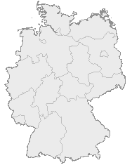
English: Map of Germany with the borders of the 16 federal states.
Deutsch: Karte von Deutschland mit den Grenzen der 16 Bundesländer. |
| Data | Data sconosciuta |
| Fonte | OpenGeoDB |
| Autore | NN/OpenGeoDB |
| Licenza (Riusare questo file) |
GFDL |
This image was generated with OpenGeoDB. The information there is placed in the public domain, images generated from OpenGeoDB are derivative works without passing the threshold of creativity, they are therefore also public domain.
| Questa immagine non possiede i requisiti per essere soggetta a copyright ed è quindi nel pubblico dominio, poiché è costituita interamente da informazioni che sono proprietà comune e non contiene condizione dell'autore originale. |

|
File:Germany location map.svg è una versione vettoriale di questo file. Dovrebbe essere usata quella versione al posto di questo file PNG, quando sia migliore.
File:Karte Deutschland.png → File:Germany location map.svg
Per maggiori informazioni, vedi Help:SVG. |
 |
Cronologia del file
Fare clic su un gruppo data/ora per vedere il file come si presentava nel momento indicato.
| Data/Ora | Miniatura | Dimensioni | Utente | Commento | |
|---|---|---|---|---|---|
| attuale | 18:46, 8 gen 2008 | | 188 × 235 (2 KB) | Evilboy (discussione | contributi) | Reverted to version as of 20:35, 14 March 2007 |
| 20:35, 14 mar 2007 |  | 188 × 235 (2 KB) | Tene~commonswiki (discussione | contributi) | Optimised (0) | |
| 11:28, 9 feb 2007 |  | 188 × 235 (2 KB) | TMg (discussione | contributi) | Contrast slightly improved without loosing precision | |
| 19:04, 31 gen 2007 |  | 188 × 235 (2 KB) | Leit (discussione | contributi) | Auf eine alte Version zurückgesetzt | |
| 18:17, 31 gen 2007 |  | 188 × 235 (8 KB) | Der Eberswalder (discussione | contributi) | ||
| 12:29, 31 gen 2007 |  | 188 × 235 (2 KB) | Rauenstein (discussione | contributi) | Auf eine alte Version zurückgesetzt | |
| 11:04, 31 gen 2007 |  | 188 × 235 (8 KB) | Der Eberswalder (discussione | contributi) | now white color outside the borders | |
| 10:31, 31 gen 2007 |  | 188 × 235 (2 KB) | Siebrand (discussione | contributi) | Eerdere versie hersteld | |
| 06:31, 31 gen 2007 |  | 188 × 235 (9 KB) | Der Eberswalder (discussione | contributi) | better viewable | |
| 15:48, 27 ago 2006 |  | 188 × 235 (2 KB) | TMg (discussione | contributi) | Slightly error corrected version, based on Image:Karte stralsund in deutschland-test.png by de:Benutzer:Rauenstein |
Impossibile sovrascrivere questo file.
Utilizzo del file
Le seguenti 8 pagine usano questo file:
Utilizzo globale del file
Anche i seguenti wiki usano questo file:
- Usato nelle seguenti pagine di ceb.wikipedia.org:
- Usato nelle seguenti pagine di da.wikipedia.org:
- Usato nelle seguenti pagine di de.wikipedia.org:
- Usato nelle seguenti pagine di nds.wikipedia.org:
- Landkreis Emsland
- Landkreis Rodenborg (Wümm)
- Landkreis Stood
- Landkreis Heidkreis
- Landkreis Vechte
- Landkreis Veern
- Kreis Noordfreesland
- Landkreis Cuxhoben
- Landkreis Oosterholt
- Landkreis Horborg
- Landkreis Lümborg
- Kreis Pinnbarg
- Landkreis Ollnborg
- Kreis Steenborg
- Landkreis Weißenburg-Gunzenhausen
- Landkreis Würzburg
- Landkreis Wunsiedel im Fichtelgebirge
- Landkreis Weilheim-Schongau
- Landkreis Unterallgäu
- Landkreis Traunstein
- Landkreis Tirschenreuth
- Landkreis Straubing-Bogen
- Landkreis Starnberg
- Landkreis Schweinfurt
- Landkreis Schwandorf
- Landkreis Rottal-Inn
- Landkreis Roth
- Landkreis Rosenheim
- Landkreis Rhön-Grabfeld
- Landkreis Paane
- Landkreis Wulfenbüttel
- Landkreis Groafschup Bentem
- Landkreis Hameln-Purmunt
- Landkreis Aichach-Friedberg
- Landkreis Altötting
- Landkreis Amberg-Sulzbach
- Landkreis Schaumborg
- Landkreis Ülzen
- Landraodsamt Stemmert
- Usato nelle seguenti pagine di pms.wikipedia.org:
Visualizza l'utilizzo globale di questo file.