File:Laghetto Moesola und Hospiz am San Bernardino Pass.jpg
Bước tới điều hướng
Bước tới tìm kiếm

Kích thước hình xem trước: 800×254 điểm ảnh. Độ phân giải khác: 320×102 điểm ảnh | 640×203 điểm ảnh | 1.024×325 điểm ảnh | 1.280×406 điểm ảnh | 2.560×813 điểm ảnh | 7.319×2.324 điểm ảnh.
Tập tin gốc (7.319×2.324 điểm ảnh, kích thước tập tin: 12,68 MB, kiểu MIME: image/jpeg)
Chú thích
Chú thích
Ghi một dòng giải thích những gì có trong tập tin này
| Miêu tả |
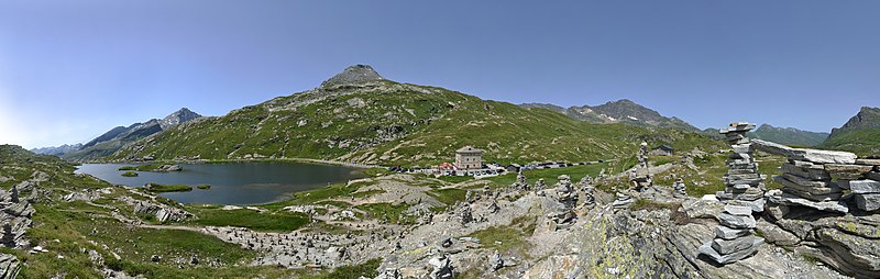
Deutsch: Der San-Bernardino-Pass ist ein Alpenpass im schweizerischen Kanton Graubünden mit einer Scheitelhöhe von 2'065 m. Er verbindet die Täler Rheinwald auf der nördlichen und Misox auf der südlichen Seite an der Hauptstrasse 13. Auf der Passhöhe verlaufen die Europäische Wasserscheide und die Sprachgrenze zwischen Deutsch und Italienisch. Am Östlichen Ufer des Laghetto Moesola verläuft die Pass Straße.
English: The San Bernardino Pass is a mountain pass in the Swiss canton of Graubünden with a summit altitude of 2,065 m. It connects the valleys of the Rhine forest on the northern and Misox on the southern side of the main road 13 At the summit, the European watershed and extend the language border between German and Italian. On the eastern shore of Laghetto Moesola the pass road runs.
|
||
| Ngày | |||
| Nguồn gốc | Tác phẩm được tạo bởi người tải lên | ||
| Tác giả |
|
||
| Giấy phép (Dùng lại tập tin) |
Tôi, người giữ bản quyền tác phẩm này, từ đây phát hành nó theo giấy phép sau: Tập tin này được phát hành theo giấy phép Creative Commons Ghi công–Chia sẻ tương tự 3.0 Áo.
 |

| Vị trí máy chụp hình | | Xem hình này và các hình ảnh lân cận trên: OpenStreetMap |
|---|
|
Lịch sử tập tin
Nhấn vào ngày/giờ để xem nội dung tập tin tại thời điểm đó.
| Ngày/Giờ | Hình xem trước | Kích cỡ | Thành viên | Miêu tả | |
|---|---|---|---|---|---|
| hiện tại | 20:20, ngày 18 tháng 9 năm 2013 | 7.319×2.324 (12,68 MB) | Böhringer (thảo luận | đóng góp) | {{Information |Description= {{de|Der San-Bernardino-Pass ist ein Alpenpass im schweizerischen Kanton Graubünden mit einer Scheitelhöhe von 2'065 m. Er verbindet die Täler Rheinwald auf der nörd... |
Bạn không được phép ghi đè tập tin này.
Trang sử dụng tập tin
15 trang sau sử dụng tập tin này:
- User:Böhringer
- User:Miya/sandbox/FP/2013/Galleries/Table
- Commons:Featured picture candidates/File:Laghetto Moesola und Hospiz am San Bernardino Pass.jpg
- Commons:Featured picture candidates/Log/October 2013
- Commons:Featured pictures/Places/Natural/Switzerland
- Commons:Featured pictures/Places/Panoramas
- Commons:Featured pictures/chronological/2013-B
- Commons:Picture of the Year/2013/Candidates
- Commons:Picture of the Year/2013/Galleries/Table
- Commons:Picture of the Year/2013/R1/Gallery/2013-B
- Commons:Picture of the Year/2013/R1/Gallery/ALL
- Commons:Picture of the Year/2013/R1/Gallery/M10
- Commons:Picture of the Year/2013/R1/Gallery/Panoramic views
- Commons:Picture of the Year/2013/R1/Results/Candidates
- Commons:Picture of the Year/2013/R1/v/Laghetto Moesola und Hospiz am San Bernardino Pass.jpg
Sử dụng tập tin toàn cục
Những wiki sau đang sử dụng tập tin này:
- Trang sử dụng tại ca.wikipedia.org
- Trang sử dụng tại de.wikipedia.org
- Trang sử dụng tại en.wikipedia.org
- Trang sử dụng tại eu.wikipedia.org
- Trang sử dụng tại mg.wikipedia.org
- Trang sử dụng tại vi.wikipedia.org