File:Lancashire UK locator map 2010.svg
Bước tới điều hướng
Bước tới tìm kiếm

Kích thước bản xem trước PNG này của tập tin SVG: 494×600 điểm ảnh. Độ phân giải khác: 198×240 điểm ảnh | 395×480 điểm ảnh | 633×768 điểm ảnh | 843×1.024 điểm ảnh | 1.687×2.048 điểm ảnh | 1.108×1.345 điểm ảnh.
Tập tin gốc (tập tin SVG, 1.108×1.345 điểm ảnh trên danh nghĩa, kích thước: 302 kB)
Chú thích
Chú thích
Ghi một dòng giải thích những gì có trong tập tin này
Юююююю .
Че
Miêu tả
[sửa]
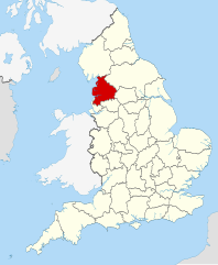
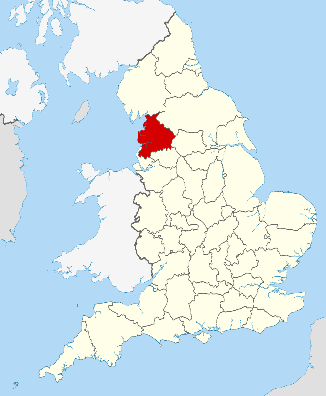
| Miêu tả | Location of the ceremonial county of Lancashire within England. |
| Ngày | |
| Nguồn gốc |
National Geospatial-Intelligence Agency
|
| Tác giả | Nilfanion |
Giấy phép
[sửa]
Tôi, người giữ bản quyền tác phẩm này, từ đây phát hành nó theo các giấy phép sau:
Tập tin này được phát hành theo Giấy phép Creative Commons Ghi công - Chia sẻ tương tự 3.0 Chưa chuyển đồi
- Bạn được phép:
- chia sẻ – sao chép, phân phối và chuyển giao tác phẩm
- pha trộn – để chuyển thể tác phẩm
- Theo các điều kiện sau:
- ghi công – Bạn phải ghi lại tác giả và nguồn, liên kết đến giấy phép, và các thay đổi đã được thực hiện, nếu có. Bạn có thể làm các điều trên bằng bất kỳ cách hợp lý nào, miễn sao không ám chỉ rằng người cho giấy phép ủng hộ bạn hay việc sử dụng của bạn.
- chia sẻ tương tự – Nếu bạn biến tấu, biến đổi, hoặc làm tác phẩm khác dựa trên tác phẩm này, bạn chỉ được phép phân phối tác phẩm mới theo giấy phép y hệt hoặc tương thích với tác phẩm gốc.

|
Bạn có quyền sao chép, phân phối và/hoặc sửa đổi tài liệu này theo những điều khoản được quy định trong Giấy phép Tài liệu Tự do GNU, phiên bản 1.2 hoặc các phiên bản mới hơn được Quỹ Phần mềm Tự do; quy định; ngoại trừ những phần không được sửa đổi, bìa trước và bìa sau. Bạn có thể xem giấy phép nói trên ở phần Giấy phép Tài liệu Tự do GNU. |
Bạn có thể chọn giấy phép mà bạn muốn.

|
This is one of the images forming part of the Valued image set: Locator maps of the Ceremonial counties of England on Wikimedia Commons. The image set has been assessed under the valued image set criteria and is considered the most valued set on Commons within the scope:
Locator maps of the Ceremonial counties of England
You can see its nomination at Commons:Valued image candidates/Locator maps of English ceremonial counties. |
Lịch sử tập tin
Nhấn vào ngày/giờ để xem nội dung tập tin tại thời điểm đó.
| Ngày/Giờ | Hình xem trước | Kích cỡ | Thành viên | Miêu tả | |
|---|---|---|---|---|---|
| hiện tại | 22:39, ngày 23 tháng 11 năm 2010 | | 1.108×1.345 (302 kB) | Nilfanion (thảo luận | đóng góp) | == Summary == {{Information |Description=Location of the ceremonial county of Lancashire within England. |Source=Ordnance Survey [https://www.ordnancesurvey.co.uk/opendatadownload/products.html OpenData]: *County bou |
Bạn không được phép ghi đè tập tin này.
Trang sử dụng tập tin
50 trang sau sử dụng tập tin này:
- Valued image set: Locator maps of the Ceremonial counties of England
- Commons:Valued image candidates/Locator maps of English ceremonial counties
- Category:Alumni by school in Lancashire
- Category:Archaeological sites in Lancashire
- Category:Bridges in Lancashire
- Category:Bus stations in Lancashire
- Category:Canals in Lancashire
- Category:Cemeteries in Lancashire
- Category:Deaths in Lancashire
- Category:Forests in Lancashire
- Category:Geography of Lancashire
- Category:Hospitals in Lancashire
- Category:Lancashire
- Category:Lancashire in the 17th century
- Category:Lancashire in the 1830s
- Category:Lancashire in the 1840s
- Category:Lancashire in the 1850s
- Category:Lancashire in the 1860s
- Category:Lancashire in the 1880s
- Category:Lancashire in the 1890s
- Category:Lancashire in the 18th century
- Category:Lancashire in the 1900s
- Category:Lancashire in the 1910s
- Category:Lancashire in the 1920s
- Category:Lancashire in the 1930s
- Category:Lancashire in the 1940s
- Category:Lancashire in the 1950s
- Category:Lancashire in the 1960s
- Category:Lancashire in the 1970s
- Category:Lancashire in the 1980s
- Category:Lancashire in the 1990s
- Category:Lancashire in the 19th century
- Category:Lancashire in the 2000s
- Category:Lancashire in the 2010s
- Category:Lancashire in the 20th century
- Category:Lancashire in the 21st century
- Category:Maps of Lancashire
- Category:People of Lancashire
- Category:Populated places in Lancashire
- Category:Prisons in Lancashire
- Category:Rail transport in Lancashire
- Category:Railway viaducts in Lancashire
- Category:Rivers of Lancashire
- Category:Roads in Lancashire
- Category:Sports in Lancashire
- Category:Towers in Lancashire
- Category:Views of Lancashire
- Category:Villages in Lancashire
- Category:Visitor attractions in Lancashire
- Category:Windmills in Lancashire
Sử dụng tập tin toàn cục
Những wiki sau đang sử dụng tập tin này:
- Trang sử dụng tại af.wikipedia.org
- Trang sử dụng tại ar.wikipedia.org
- Trang sử dụng tại ast.wikipedia.org
- Trang sử dụng tại az.wikipedia.org
- Trang sử dụng tại be-tarask.wikipedia.org
- Trang sử dụng tại be.wikipedia.org
- Trang sử dụng tại bg.wikipedia.org
- Trang sử dụng tại br.wikipedia.org
- Trang sử dụng tại ca.wikipedia.org
- Trang sử dụng tại ceb.wikipedia.org
- Trang sử dụng tại cs.wikipedia.org
- Trang sử dụng tại en.wikipedia.org
- Lancashire
- National nature reserves in Lancashire
- Grit Fell
- Wolfhole Crag
- Fair Snape Fell
- Leyland Hundred
- Lonsdale Hundred
- Bleasdale
- Knott End-on-Sea
- Great Altcar
- Trawden
- White Hill (Forest of Bowland)
- Hawthornthwaite Fell
- Gambleside
- Brownhill
- Catforth
- Over Wyre
- Oakenshaw, Lancashire
- Langho
- River Tawd
- Downholland Cross
- Haskayne
- Farington
- Salwick
- Barrow Nook
- Foulridge
- Wennington, Lancashire
- Template:Lancashire-geo-stub
- Eagland Hill
- Yarrow Valley Country Park
- Quernmore
- Central Lancashire
- Whittington, Lancashire
- River Hyndburn
- Barley-with-Wheatley Booth
- Barnacre-with-Bonds
- Bickerstaffe
- Municipal Borough of Morecambe and Heysham
Xem thêm các trang toàn cục sử dụng tập tin này.