File:London Overground as a circle.svg
Jump to navigation
Jump to search

Size of this PNG preview of this SVG file: 688 × 599 pixels. Other resolutions: 276 × 240 pixels | 551 × 480 pixels | 882 × 768 pixels | 1,176 × 1,024 pixels | 2,351 × 2,048 pixels | 1,240 × 1,080 pixels.
Original file (Animated SVG file, nominally 1,240 × 1,080 pixels, file size: 42 KB)
Note: Due to technical limitations, thumbnails of this file will not be animated.
Captions
Captions
Add a one-line explanation of what this file represents
Summary[edit]
| Description |
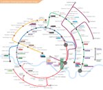
English: London Overground Network, circular design. Hover or tap the line will highlight it in blue. On mouse-less device, this effect can be canceled by tapping the empty background. |
|||
| Date | ||||
| Source | Own work (Original text: I created this work entirely by myself.) | |||
| Author |
|
|||
| Other versions |
|
|||
| SVG development | This map was created with an unknown SVG tool. |


|
This image is an animated SVG file. The .png preview above created by RSVG for use in Wikimedia is not animated and may be incomplete or incorrect. To see the animation, open media:London Overground as a circle.svg. It should run in any modern browser or viewer. Recent versions of Chrome, Firefox, Microsoft Edge, Safari, and Opera all support SVG animated with SMIL.
Other SVG animations can be found at Category:Animated SVG files.
|
Licensing[edit]
| This work has been released into the public domain by its author, Briantist at English Wikipedia. This applies worldwide. In some countries this may not be legally possible; if so: Briantist grants anyone the right to use this work for any purpose, without any conditions, unless such conditions are required by law. |
Original upload log[edit]
Transferred from en.wikipedia to Commons by Tm using CommonsHelper.
The original description page was here. All following user names refer to en.wikipedia.
- 2009-02-15 11:53 Briantist 886×886× (846984 bytes) Spelling corrections and changed font to a London-Transport style, larger font and correct station markers
- 2009-02-14 13:26 Briantist 886×886× (948169 bytes) XML error removed
- 2009-02-14 13:18 Briantist 886×886× (1133428 bytes) {{Information |Description=London Overground Network, circular design |Source=I created this work entirely by myself. |Date=14 Feb 2009 |Author=~~~ |other_versions= }}
File history
Click on a date/time to view the file as it appeared at that time.
| Date/Time | Thumbnail | Dimensions | User | Comment | |
|---|---|---|---|---|---|
| current | 12:13, 25 February 2024 | | 1,240 × 1,080 (42 KB) | Sameboat (talk | contribs) | Renwick Road -> Castle Green |
| 15:16, 16 February 2024 |  | 1,240 × 1,080 (41 KB) | Sameboat (talk | contribs) | ||
| 15:12, 16 February 2024 |  | 1,240 × 1,080 (41 KB) | Sameboat (talk | contribs) | ||
| 11:05, 19 July 2022 |  | 1,240 × 1,080 (40 KB) | Sameboat (talk | contribs) | ||
| 11:02, 19 July 2022 |  | 1,240 × 1,080 (40 KB) | Sameboat (talk | contribs) | Barking Riverside | |
| 10:41, 24 May 2022 |  | 1,240 × 1,080 (40 KB) | Sameboat (talk | contribs) | swap interchange order in Stratford to make sense of reality | |
| 05:43, 23 May 2022 |  | 1,240 × 1,080 (40 KB) | Sameboat (talk | contribs) | New Bermondsey -> Surrey Canal | |
| 05:26, 23 May 2022 |  | 1,240 × 1,080 (40 KB) | Sameboat (talk | contribs) | Elizabeth line | |
| 03:24, 30 December 2020 |  | 1,240 × 1,080 (40 KB) | Sameboat (talk | contribs) | wrap <Defs> instances in <g id="xxx"> | |
| 04:50, 19 January 2019 |  | 1,240 × 1,080 (40 KB) | Sameboat (talk | contribs) | Update OSIs |
You cannot overwrite this file.
File usage on Commons
The following 44 pages use this file:
- London Overground
- User:Chumwa/OgreBot/Potential transport maps/2016 March 21-31
- User:Chumwa/OgreBot/Potential transport maps/2016 May 21-31
- User:Chumwa/OgreBot/Potential transport maps/2018 July 11-20
- User:Chumwa/OgreBot/Potential transport maps/2019 January 11-20
- User:Chumwa/OgreBot/Public transport information/2015 July 11-20
- User:Chumwa/OgreBot/Public transport information/2015 July 21-31
- User:Chumwa/OgreBot/Public transport information/2016 March 21-31
- User:Chumwa/OgreBot/Public transport information/2016 May 21-31
- User:Chumwa/OgreBot/Public transport information/2018 July 11-20
- User:Chumwa/OgreBot/Public transport information/2019 January 11-20
- User:Chumwa/OgreBot/Public transport information/2020 December 21-31
- User:Chumwa/OgreBot/Public transport information/2022 July 11-20
- User:Chumwa/OgreBot/Public transport information/2022 May 21-31
- User:Chumwa/OgreBot/Public transport information/2024 February 10-19
- User:Chumwa/OgreBot/Public transport information/2024 February 20-29
- User:Chumwa/OgreBot/Transport Maps/2015 July 11-20
- User:Chumwa/OgreBot/Transport Maps/2015 July 21-31
- User:Chumwa/OgreBot/Transport Maps/2016 March 21-31
- User:Chumwa/OgreBot/Transport Maps/2016 May 21-31
- User:Chumwa/OgreBot/Transport Maps/2018 July 11-20
- User:Chumwa/OgreBot/Transport Maps/2019 January 11-20
- User:Chumwa/OgreBot/Transport Maps/2020 December 21-31
- User:Chumwa/OgreBot/Transport Maps/2022 July 11-20
- User:Chumwa/OgreBot/Transport Maps/2022 May 21-31
- User:Chumwa/OgreBot/Transport Maps/2024 February 10-19
- User:Chumwa/OgreBot/Transport Maps/2024 February 20-29
- User:Chumwa/OgreBot/Travel and communication maps/2016 March 21-31
- User:Chumwa/OgreBot/Travel and communication maps/2016 May 21-31
- User:Chumwa/OgreBot/Travel and communication maps/2018 July 11-20
- User:Chumwa/OgreBot/Travel and communication maps/2019 January 11-20
- User:Mattbuck/Railways/2015 July 11-20
- User:Mattbuck/Railways/2015 July 21-31
- User:Mattbuck/Railways/2016 March 21-31
- User:Mattbuck/Railways/2016 May 21-31
- User:Mattbuck/Railways/2018 July
- User:Mattbuck/Railways/2019 January
- User:Mattbuck/Railways/2020 December
- User:Mattbuck/Railways/2022 July
- User:Mattbuck/Railways/2022 May
- User:Mattbuck/Railways/2024 February
- User:Sameboat
- File:London Overground as a circle.pdf
- File:London Overground as a circle.svg
File usage on other wikis
The following other wikis use this file:
- Usage on en.wikipedia.org
- Usage on fr.wikipedia.org
- Usage on id.wikipedia.org
- Usage on ko.wikipedia.org
- Usage on nl.wikipedia.org
- Usage on wikimania2014.wikimedia.org