File:Magni Ducatus Lithuaniae Dnieper.jpg
Jump to navigation
Jump to search
Size of this preview: 271 × 598 pixels. Other resolutions: 108 × 240 pixels | 217 × 480 pixels | 348 × 768 pixels | 1,024 × 2,260 pixels.
Original file (1,024 × 2,260 pixels, file size: 3.12 MB, MIME type: image/jpeg)
Captions
Captions
Add a one-line explanation of what this file represents
Summary[edit]
| Description |
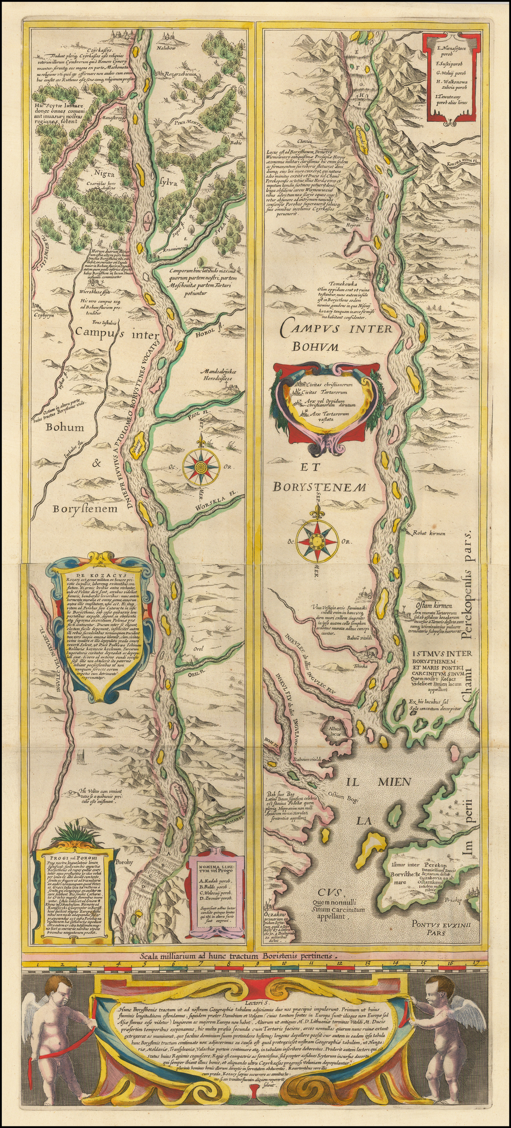
English: Map of the lower course of Dnieper River
Українська: «Борисфенський шлях» (нижня течія Дніпра). Амстердам. 1643 рік |
| Date | |
| Source | Атлас "Украина на старинных картах", своё сканирование |
| Author |
English: Tomasz Makowski and Willem Yanson Blau Русский: Томаш Маковский (Речь Посполитая) и Виллем Янсон Блау (Нидерланды). |
Licensing[edit]
|
This work is in the public domain in its country of origin and other countries and areas where the copyright term is the author's life plus 100 years or fewer. | |
| This file has been identified as being free of known restrictions under copyright law, including all related and neighboring rights. | |
Original upload log[edit]
Transferred from ru.wikipedia to Commons. The original description page is/was here. All following user names refer to ru.wikipedia.
- 2009-06-12 15:22 Vizu 1228×2592× (4909876 bytes) {{Изображение1 | Описание =1 | Источник =1 | Время создания =1 | Автор =1 }}
File history
Click on a date/time to view the file as it appeared at that time.
| Date/Time | Thumbnail | Dimensions | User | Comment | |
|---|---|---|---|---|---|
| current | 07:39, 23 October 2022 | | 1,024 × 2,260 (3.12 MB) | Arxivist (talk | contribs) | upd, coulr |
| 11:15, 3 July 2009 |  | 1,228 × 2,592 (4.68 MB) | Rubinbot (talk | contribs) | {{BotMoveToCommons|ru.wikipedia|year={{subst:CURRENTYEAR}}|month={{subst:CURRENTMONTHNAME}}|day={{subst:CURRENTDAY}}}} {{Information |Description={{ru|@Борисфенский путь@ (нижнее течение ru:Днепра). Голлан� |
You cannot overwrite this file.
File usage on Commons
The following 2 pages use this file:
File usage on other wikis
The following other wikis use this file:
- Usage on be-tarask.wikipedia.org
- Usage on pl.wikipedia.org
- Usage on ru.wikipedia.org
- Usage on uk.wikipedia.org