File:Map of Greece, Archipelago and part of Anadoli; Louis Stanislas d'Arcy Delarochette 1791.jpg
Bước tới điều hướng
Bước tới tìm kiếm

Kích thước hình xem trước: 800×561 điểm ảnh. Độ phân giải khác: 320×225 điểm ảnh | 640×449 điểm ảnh | 1.024×719 điểm ảnh | 1.280×898 điểm ảnh | 2.560×1.797 điểm ảnh | 9.411×6.605 điểm ảnh.
Tập tin gốc (9.411×6.605 điểm ảnh, kích thước tập tin: 15,99 MB, kiểu MIME: image/jpeg)
Chú thích
Chú thích
Ghi một dòng giải thích những gì có trong tập tin này
Ionia is the west coast region of Anatolia (present-day Turkey)
Miêu tả[sửa]
| Miêu tả |
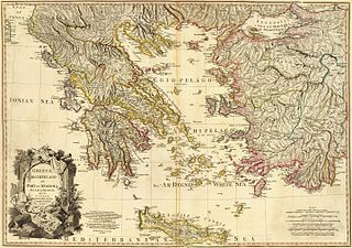
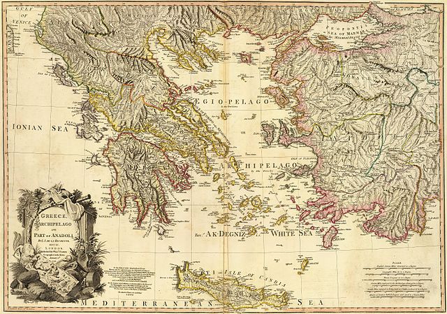
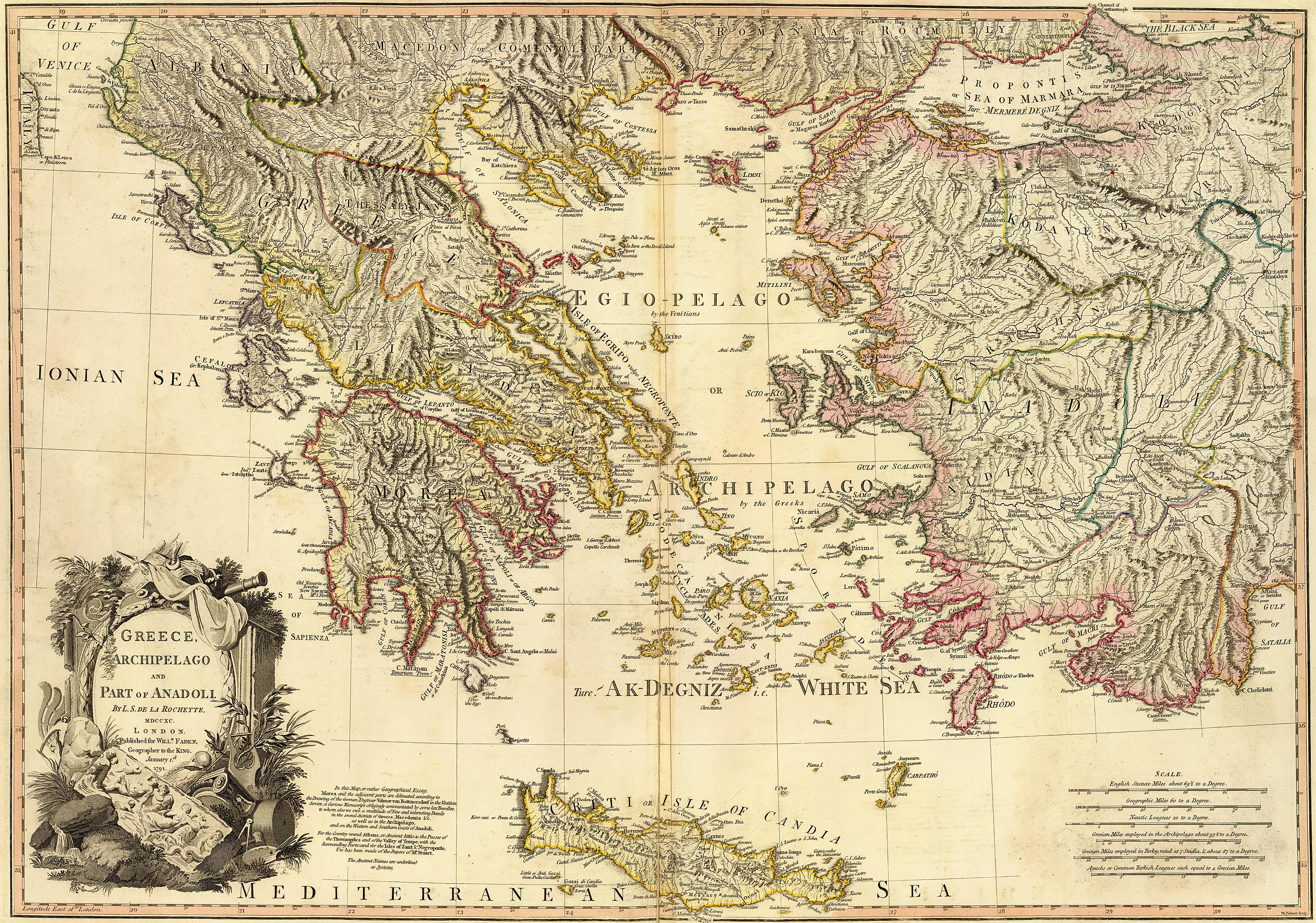
Greece, Archipelago and part of Anadoli. Published for Willm. Faden, Geographer to the King. W. Palmer sculp. . Scale: 1,350,000 |
| Ngày | |
| Nguồn gốc | http://www.davidrumsey.com/luna/servlet/detail/RUMSEY~8~1~24845~960053?trs=120&mi=23&qvq=mgid%3A2728# |
| Tác giả | Louis Stanislas d'Arcy Delarochette |
| Phiên bản khác |
|
.jpg)
.jpg)
.jpg)
Giấy phép[sửa]
|
Tác phẩm này thuộc về phạm vi công cộng tại quốc gia gốc và các quốc gia và vùng lãnh thổ có thời hạn bản quyền là cuộc đời tác giả cộng thêm 100 trở xuống. Tác phẩm này thuộc về phạm vi công cộng ở Hoa Kỳ vì nó được phát hành trước ngày 1 tháng 1 năm 1929. | |
| Tập tin này đã được đánh dấu là không bị hạn chế dưới luật bản quyền, kể cả tất cả những quyền liên quan và lần cận. | |
| Cảnh báo | Một số trình duyệt có thể gặp trở ngại trong việc hiển thị hình này ở cỡ đầy đủ. Hình này có một số lượng điểm ảnh lớn và có thể không được tải chính xác hoặc làm trình duyệt bị treo. |
|---|
| Annotations | This image is annotated: View the annotations at Commons |

Lịch sử tập tin
Nhấn vào ngày/giờ để xem nội dung tập tin tại thời điểm đó.
| Ngày/Giờ | Hình xem trước | Kích cỡ | Thành viên | Miêu tả | |
|---|---|---|---|---|---|
| hiện tại | 15:05, ngày 9 tháng 6 năm 2016 | | 9.411×6.605 (15,99 MB) | HerrAdams (thảo luận | đóng góp) | Removed border by cropping 20 % horizontally and 13 % vertically using CropTool with lossless mode. |
| 17:11, ngày 4 tháng 5 năm 2016 |  | 11.730×7.600 (20,32 MB) | Mattes (thảo luận | đóng góp) | == {{int:filedesc}} == {{Information |Description= Greece, Archipelago and part of Anadoli. By L.S. de la Rochette, MDCCXC. London. Published for Willm. Faden, Geographer to the King. January 1st, 1791. W. Palmer sculp. . Scale: 1,350,000 |Source=http:... |
Bạn không được phép ghi đè tập tin này.
Trang sử dụng tập tin
Trang sau sử dụng tập tin này:
Sử dụng tập tin toàn cục
Những wiki sau đang sử dụng tập tin này:
- Trang sử dụng tại en.wikipedia.org
- Aegean civilization
- Dorians
- Ostracism
- History of Cyprus
- Timeline of ancient Greece
- Ancient Greece
- Miletus
- Minoan civilization
- Pelasgians
- Greek War of Independence
- Ionians
- Greek Dark Ages
- Cycladic culture
- Hellenistic period
- History of Greece
- Mycenaean Greece
- Hellenistic Greece
- Byzantine Greece
- Ottoman Greece
- Dorian invasion
- Template:History of Greece
- Aeolians
- Helladic chronology
- Archaic Greece
- Greek junta
- Military history of Greece
- Greece in the Roman era
- Ionian League
- 4th of August Regime
- Names of the Greeks
- National Schism
- History of modern Macedonia (Greece)
- Chronology of ancient Greek mathematicians
- History of the Hellenic Republic
- Timeline of modern Greek history
- Second Hellenic Republic
- Economic history of Greece and the Greek world
- Talk:History of the Assyrians
- Classical Greece
- User:Athinaios/Sandbox
- Hellenic State (1941–1944)
- Frankokratia
- Timeline of ancient Greek mathematicians
- Timeline of calculus and mathematical analysis
- History of Sparta
- Greece in the Balkan Wars
- Background of the Greek War of Independence
- Achaeans (tribe)
- Category:History of Greece by period
- Venetian rule in the Ionian Islands
Xem thêm các trang toàn cục sử dụng tập tin này.