File:Map of ancient Paeonia and environs (English).svg
Jump to navigation
Jump to search

Size of this PNG preview of this SVG file: 800 × 430 pixels. Other resolutions: 320 × 172 pixels | 640 × 344 pixels | 1,024 × 550 pixels | 1,280 × 687 pixels | 2,560 × 1,375 pixels | 1,214 × 652 pixels.
Original file (SVG file, nominally 1,214 × 652 pixels, file size: 381 KB)
Captions
Captions
Add a one-line explanation of what this file represents
Summary
[edit].svg&action=edit§ion=1)
| Description |
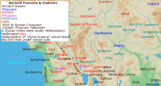
English: Map of Paeonia aka Paionia & Environs prior to Greek and Roman conquest |
| Date | |
| Source | Own work |
| Author | MaryroseB54 |
- The classical age of Greece (1999),
- ed. Atlas of the Greek and Roman world in antiquity (1981).
- Hammond, N. G. L. A History of Greece to 322 B.C., 1986, ISBN-10: 0198730950
- Wilkes, J. J. The Illyrians, 1992,ISBN 0631198075,
- In the Shadow of Olympus: The Emergence of Macedon,ISBN 0691008809,1992
- Thracian Tribal areas (from Fol, Thrace and the Thracians, p 133),The Thracians 700 BC–AD 46 (Men-at-Arms 360) by Christopher Webber After Hoddinot, Col & Cah
- Herman, Mogens. An Inventory of Archaic and Classical Poleis, 2004, p. 348, ISBN 0198140991
- Blank map from Image:Map greek sanctuaries-fr.svg.
Licensing
[edit].svg&action=edit§ion=2)
I, the copyright holder of this work, hereby publish it under the following license:
This file is licensed under the Creative Commons Attribution-Share Alike 4.0 International license.
- You are free:
- to share – to copy, distribute and transmit the work
- to remix – to adapt the work
- Under the following conditions:
- attribution – You must give appropriate credit, provide a link to the license, and indicate if changes were made. You may do so in any reasonable manner, but not in any way that suggests the licensor endorses you or your use.
- share alike – If you remix, transform, or build upon the material, you must distribute your contributions under the same or compatible license as the original.
.svg)
|
This SVG file contains embedded text that can be translated into your language, using any capable SVG editor, text editor or the SVG Translate tool. For more information see: About translating SVG files. |
.svg)
File history
Click on a date/time to view the file as it appeared at that time.
| Date/Time | Thumbnail | Dimensions | User | Comment | |
|---|---|---|---|---|---|
| current | 12:04, 4 July 2016 | | 1,214 × 652 (381 KB) | MaryroseB54 (talk | contribs) | Cities |
| 08:43, 4 July 2016 |  | 1,214 × 652 (381 KB) | MaryroseB54 (talk | contribs) | User created page with UploadWizard |
You cannot overwrite this file.
File usage on Commons
The following 5 pages use this file:
File usage on other wikis
The following other wikis use this file:
- Usage on bg.wikipedia.org
- Usage on da.wikipedia.org
- Usage on el.wikipedia.org
- Usage on en.wikipedia.org
- Usage on eo.wikipedia.org
- Usage on fa.wikipedia.org
- Usage on hr.wikipedia.org
- Usage on id.wikipedia.org
- Usage on ka.wikipedia.org
- Usage on ko.wikipedia.org
- Usage on lt.wikipedia.org
- Usage on mk.wikipedia.org
- Usage on no.wikipedia.org
- Usage on ro.wikipedia.org
- Usage on ru.wikipedia.org
- Usage on sl.wikipedia.org
- Usage on sr.wikipedia.org
- Usage on sv.wikipedia.org
- Usage on tr.wikipedia.org
- Usage on uk.wikipedia.org
- Usage on zh.wikipedia.org
.svg&oldid=606469017)