File:Odoacer 480ad.jpg

Tập tin gốc (900×545 điểm ảnh, kích thước tập tin: 701 kB, kiểu MIME: image/jpeg)
Chú thích
Chú thích

|
Hình ảnh thuộc thể loại "historical map" cần được vẽ lại bằng đồ họa vector theo định dạng tập tin SVG. Để biết ưu điểm của định dạng này, hãy đọc Commons:Media for cleanup. Nếu tập tin này đã có SVG, xin hãy tải lên đây rồi thay bản mẫu này bằng {{vector version available|tên hình mới.svg}}.
|


Miêu tả[sửa]
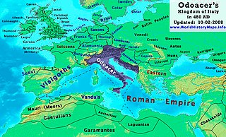
| Miêu tả | Odoacer's Kingdom of Italy in 480 AD. |
| Ngày | |
| Nguồn gốc | Tác phẩm được tạo bởi người tải lên |
| Tác giả | Thomas Lessman (Contact!) |
| Giấy phép (Dùng lại tập tin) |
Tôi, người giữ bản quyền tác phẩm này, từ đây phát hành nó theo giấy phép sau: Tập tin này được phát hành theo Giấy phép Creative Commons Ghi công - Chia sẻ tương tự 3.0 Chưa chuyển đồi
|
| Phiên bản khác | See Below |
Map Summary[sửa]
Original Source URL: http://www.thomaslessman.com/History/images/East-Hem_480ad.jpg or www.WorldHistoryMaps.info
This map of the Kingdom of Odoacer in 480 AD is a zoomed-in version of Thomas Lessman's map of the East-Hem 480 AD, also available at www.WorldHistoryMaps.info.
The highlighted areas represent Odoacer's Kingdom of Italy, after the capture of Italy (476), conquest of Sicily from the Vandals (477) and the annexation of Dalmatia after the assassination of Emperor Julius Nepos (480).
Map Source References[sửa]
Remember, sources often conflict with each other. This map is only as accurate as the information that is available to me. To report any errors or to help further this work, please click here, or email Thomas Lessman at talessman@yis.us
References for information contained in this map:
Other Maps by Thomas Lessman[sửa]
| Maps of the eastern hemisphere showing history
Bold dates are available on Wikimedia or Wikipedia. | ||
| Primeval | ||
| Ancient
|
·| 600 BC | 550 BC | 527 BC | 500 BC |
400 BC | ·| 1 AD | 50 AD | 100 AD | 200 AD | 300 AD | | |
| Medieval |
·| 500 AD | 565 AD | 600 AD | 700 AD | | |
| Modern |
·| 1500 AD | · * For historical maps of the whole world, | |
Lịch sử tập tin
Nhấn vào ngày/giờ để xem nội dung tập tin tại thời điểm đó.
| Ngày/Giờ | Hình xem trước | Kích cỡ | Thành viên | Miêu tả | |
|---|---|---|---|---|---|
| hiện tại | 19:50, ngày 23 tháng 10 năm 2022 | | 900×545 (701 kB) | Gyalu22 (thảo luận | đóng góp) | Reverted bad faith edit. The Westermanns Atlas doesn't show the Carpi |
| 16:05, ngày 15 tháng 9 năm 2015 |  | 900×545 (727 kB) | Spiridon Ion Cepleanu (thảo luận | đóng góp) | Details about the low-Danube according with H.E.Stier's (dir.) Grosser Atlas zur Weltgeschichte, Westermann 1985. | |
| 21:40, ngày 2 tháng 10 năm 2008 |  | 900×545 (701 kB) | Talessman (thảo luận | đóng góp) | {{Information |Description= |Source= |Date= |Author= |Permission= |other_versions= }} | |
| 10:29, ngày 10 tháng 5 năm 2008 |  | 1.402×1.023 (380 kB) | Talessman (thảo luận | đóng góp) | {{Information |Description=<big>'''The Odoacer's Kingdom of Italy in 477 AD.'''</big> |Source=Self-made |Author=Thomas Lessman |Permission={{self|cc-by-sa-3.0}} }} |
Bạn không được phép ghi đè tập tin này.
Trang sử dụng tập tin
2 trang sau sử dụng tập tin này:
Sử dụng tập tin toàn cục
Những wiki sau đang sử dụng tập tin này:
- Trang sử dụng tại azb.wikipedia.org
- Trang sử dụng tại ba.wikipedia.org
- Trang sử dụng tại bg.wikipedia.org
- Trang sử dụng tại br.wikipedia.org
- Trang sử dụng tại ca.wikipedia.org
- Trang sử dụng tại de.wikipedia.org
- Trang sử dụng tại el.wikipedia.org
- Trang sử dụng tại en.wikipedia.org
- Trang sử dụng tại es.wikipedia.org
- Trang sử dụng tại eu.wikipedia.org
- Trang sử dụng tại fi.wikipedia.org
- Trang sử dụng tại fr.wikipedia.org
- Trang sử dụng tại fy.wikipedia.org
- Trang sử dụng tại hy.wikipedia.org
- Trang sử dụng tại ia.wikipedia.org
- Trang sử dụng tại it.wikipedia.org
- Trang sử dụng tại ja.wikipedia.org
- Trang sử dụng tại ko.wikipedia.org
- Trang sử dụng tại li.wikipedia.org
- Trang sử dụng tại lmo.wikipedia.org
- Trang sử dụng tại lt.wikipedia.org
- Trang sử dụng tại lv.wikipedia.org
- Trang sử dụng tại nds.wikipedia.org
- Trang sử dụng tại nl.wikipedia.org
- Trang sử dụng tại pl.wikipedia.org
Xem thêm các trang toàn cục sử dụng tập tin này.
- Maps of regions showing history by year-spans
- Maps of the world showing history
- Maps of the Roman Empire
- Maps of the Byzantine Empire
- Maps of the European Antiquity
- Maps of historical states of Italy
- Maps of 5th-century Africa
- Maps of the Kingdom of Odoacer
- Maps of 5th-century Europe
- Romania in the 5th century
- Maps of the Suebi
- Maps of the Heruli
- Modifications of the history maps by Thomas A. Lessmann
- Maps showing 480