File:Queen Charlotte Islands Map.png
Jump to navigation
Jump to search

Size of this preview: 392 × 600 pixels. Other resolutions: 157 × 240 pixels | 496 × 759 pixels.
Original file (496 × 759 pixels, file size: 23 KB, MIME type: image/png)
Captions
Captions
Add a one-line explanation of what this file represents

|
This image could be re-created using vector graphics as an SVG file. This has several advantages; see Commons:Media for cleanup for more information. If an SVG form of this image is available, please upload it and afterwards replace this template with
{{vector version available|new image name}}.
It is recommended to name the SVG file “Queen Charlotte Islands Map.svg”—then the template Vector version available (or Vva) does not need the new image name parameter. |
Summary[edit]
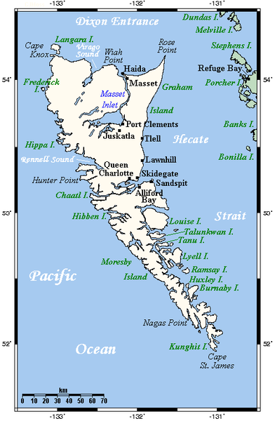
A map showing Haida Gwaii's main towns and other physical features. This map's source is here, with the uploader's modifications, and the GMT homepage archive copy at the Wayback Machine says that the tools are released under the GNU General Public License.
Uploaded from en:Image:HaidaGwaiiOMC.png by TCY
Licensing[edit]
English Wikipedia user Kelisi, the copyright holder of this work, hereby publishes it under the following license:

|
Permission is granted to copy, distribute and/or modify this document under the terms of the GNU Free Documentation License, Version 1.2 or any later version published by the Free Software Foundation; with no Invariant Sections, no Front-Cover Texts, and no Back-Cover Texts. A copy of the license is included in the section entitled GNU Free Documentation License. |
| This file is licensed under the Creative Commons Attribution-Share Alike 3.0 Unported license. | ||
| Attribution: English Wikipedia user Kelisi | ||
| ||
| This licensing tag was added to this file as part of the GFDL licensing update. |
File history
Click on a date/time to view the file as it appeared at that time.
| Date/Time | Thumbnail | Dimensions | User | Comment | |
|---|---|---|---|---|---|
| current | 05:59, 14 September 2007 | | 496 × 759 (23 KB) | TCY (talk | contribs) | == Summary == A map showing Haida Gwaii's main towns and other physical features. This map's source is [http://www.aquarius.ifm-geomar.de/ here], with the uploader's modifications, and the [http://gmt.soest.hawaii.edu/ GMT homepage] says that the tools ar |
You cannot overwrite this file.
File usage on Commons
The following 2 pages use this file:
File usage on other wikis
The following other wikis use this file:
- Usage on af.wikipedia.org
- Usage on ar.wikipedia.org
- Usage on az.wikipedia.org
- Usage on ban.wikipedia.org
- Usage on be.wikipedia.org
- Usage on bg.wikipedia.org
- Usage on br.wikipedia.org
- Usage on bs.wikipedia.org
- Usage on ca.wikipedia.org
- Usage on ceb.wikipedia.org
- Usage on cs.wikipedia.org
- Usage on da.wikipedia.org
- Usage on de.wikipedia.org
- Usage on de.wikivoyage.org
- Usage on en.wikipedia.org
- Usage on eo.wikipedia.org
- Usage on es.wikipedia.org
- Usage on es.wikinews.org
- Usage on et.wikipedia.org
- Usage on eu.wikipedia.org
- Usage on fa.wikipedia.org
- Usage on fi.wikipedia.org
- Usage on fr.wikipedia.org
- Usage on fy.wikipedia.org
- Usage on ga.wikipedia.org
- Usage on gl.wikipedia.org
- Usage on hr.wikipedia.org
- Usage on id.wikipedia.org
View more global usage of this file.