File:Roman Empire 125 political map.svg
Jump to navigation
Jump to search

Size of this PNG preview of this SVG file: 721 × 599 pixels. Other resolutions: 289 × 240 pixels | 578 × 480 pixels | 924 × 768 pixels | 1,232 × 1,024 pixels | 2,464 × 2,048 pixels | 2,186 × 1,817 pixels.
Original file (SVG file, nominally 2,186 × 1,817 pixels, file size: 3.25 MB)
Captions
Captions
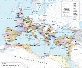
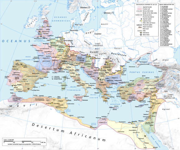
A map of the Roman Empire in 125 AD, during the reign of the emperor Hadrian

| Camera location | | View this and other nearby images on: OpenStreetMap |
|---|
Summary
[edit]| Description |
English: Map of the Roman Empire in 125.
Projection Lambert azimuthal-equal area. Central latitude: 45° N, central longitude: 20° E. X, Y origin offset - 0 Datum: ETRS89 Sources The physical map was made using the following public domain sources:
Additional references for the map content:
Software used GIS:
Graphics editors:
|
| Date | |
| Source | Own work |
| Author | User:ArdadN & reviewer - User:EraNavigator |
| Other versions |
[]
|


Licensing
[edit]
I, the copyright holder of this work, hereby publish it under the following licenses:
This file is licensed under the Creative Commons Attribution-Share Alike 3.0 Unported license.
- You are free:
- to share – to copy, distribute and transmit the work
- to remix – to adapt the work
- Under the following conditions:
- attribution – You must give appropriate credit, provide a link to the license, and indicate if changes were made. You may do so in any reasonable manner, but not in any way that suggests the licensor endorses you or your use.
- share alike – If you remix, transform, or build upon the material, you must distribute your contributions under the same or compatible license as the original.

|
Permission is granted to copy, distribute and/or modify this document under the terms of the GNU Free Documentation License, Version 1.2 or any later version published by the Free Software Foundation; with no Invariant Sections, no Front-Cover Texts, and no Back-Cover Texts. A copy of the license is included in the section entitled GNU Free Documentation License. |
You may select the license of your choice.
_en.png)
.png)
.jpg)
File history
Click on a date/time to view the file as it appeared at that time.
| Date/Time | Thumbnail | Dimensions | User | Comment | |
|---|---|---|---|---|---|
| current | 12:31, 30 January 2024 | | 2,186 × 1,817 (3.25 MB) | ArdadN (talk | contribs) | removed author caption |
| 09:51, 6 October 2021 |  | 2,186 × 1,817 (3.25 MB) | Goran tek-en (talk | contribs) | Name changed to Paphus, Cnossus, Chersonesus, Chesinos as requested by GPinkerton | |
| 21:30, 2 October 2021 |  | 2,186 × 1,817 (3.27 MB) | Goran tek-en (talk | contribs) | Pahpus changed to Paphos requested by Kintetsubuffalo | |
| 18:14, 20 July 2015 |  | 2,186 × 1,817 (3.27 MB) | ArdadN (talk | contribs) | 1 | |
| 17:54, 20 July 2015 |  | 2,186 × 1,817 (3.27 MB) | ArdadN (talk | contribs) | 1 | |
| 17:06, 3 March 2015 |  | 2,186 × 1,817 (3.27 MB) | ArdadN (talk | contribs) | new road added | |
| 13:48, 10 February 2015 |  | 2,186 × 1,817 (3.28 MB) | ArdadN (talk | contribs) | 1 | |
| 18:43, 20 May 2014 |  | 2,186 × 1,817 (3.27 MB) | ArdadN (talk | contribs) | 1 | |
| 18:33, 9 April 2014 |  | 2,186 × 1,817 (3.26 MB) | ArdadN (talk | contribs) | scotti | |
| 19:27, 4 April 2014 |  | 2,186 × 1,817 (3.26 MB) | ArdadN (talk | contribs) | 1 |
You cannot overwrite this file.
File usage on Commons
The following 21 pages use this file:
- User:Chumwa/OgreBot/Transport Maps/2015 February 10-18
- User:Chumwa/OgreBot/Transport Maps/2015 July 11-20
- User:Chumwa/OgreBot/Transport Maps/2015 March 1-10
- User:Chumwa/OgreBot/Transport Maps/2021 October 1-10
- User:Chumwa/OgreBot/Transport Maps/2024 January 21-31
- User:Chumwa/OgreBot/Travel and communication maps/2021 October 1-10
- User:Chumwa/OgreBot/Travel and communication maps/2024 January 21-31
- Commons:Graphic Lab/Map workshop/Archive/2021
- File:ROMAN EMPIRE ADMIN.svg (file redirect)
- File:Roman Empire 125.png
- File:Roman Empire 125 general map-zh.png
- File:Roman Empire 125 general map-zh.svg
- File:Roman Empire 125 general map.SVG
- File:Roman Empire 125 general map pl.svg
- File:Roman Empire 125 political map-de.svg
- File:Roman Empire 125 political map-zh.png
- File:Roman Empire 125 political map-zh.svg
- File:Roman Empire 125 political map.png
- File:Roman Empire 125 political map.svg
- File:Roman Empire 125 political map pl.svg
- Template:Other versions/Roman Empire 125 map
File usage on other wikis
The following other wikis use this file:
- Usage on ar.wikipedia.org
- Usage on azb.wikipedia.org
- Usage on el.wikipedia.org
- Usage on en.wikipedia.org
- Usage on es.wikipedia.org
- Usage on et.wikipedia.org
- Usage on fr.wikipedia.org
- Usage on gl.wikipedia.org
- Usage on ko.wikipedia.org
- Usage on mt.wikipedia.org
- Usage on pt.wikipedia.org
- Usage on ro.wikipedia.org
- Usage on ru.wikipedia.org
- Usage on sl.wikipedia.org
- Usage on uk.wikipedia.org
Metadata
Categories:
- Maps of the Roman Empire in 125 AD
- SVG maps of the Roman Empire
- Maps of Roman provinces
- Maps of the history of Romania in ancient times
- Maps of the European Antiquity
- Maps of Dacian tribes
- Maps of Roman Dacia
- Maps of ancient Roman roads
- 125 in Europe
- Historical maps of the Carpathian Mountains
- Pomerania in the 1st century
- Oksywie culture
- Wielbark culture maps
- Poland in the 1st century
- Pomerania in the 2nd century
- Poland in the 2nd century
- Bastarnae
- Burgundians
- Carpi people
- Costoboci
- Maps of the Gepids
- Maps of the Goths
- Hasdingi
- Iazyges
- Marcomanni
- Quadi
- Maps of the Rugii
- Maps of the Scythians
- Silingi
- Maps of the Vandals