File:Sëlva Wolkenstein Selva di Val Gardena Sella.jpg
Bước tới điều hướng
Bước tới tìm kiếm

Kích thước hình xem trước: 800×415 điểm ảnh. Độ phân giải khác: 320×166 điểm ảnh | 640×332 điểm ảnh | 1.024×531 điểm ảnh | 1.280×664 điểm ảnh | 2.560×1.327 điểm ảnh | 11.723×6.078 điểm ảnh.
Tập tin gốc (11.723×6.078 điểm ảnh, kích thước tập tin: 51,52 MB, kiểu MIME: image/jpeg)
Chú thích
Chú thích
Ghi một dòng giải thích những gì có trong tập tin này
Miêu tả[sửa]
| Miêu tả |
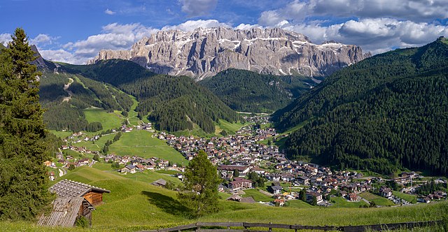
English: View of the town of Sëlva with the Cir and Sella mountain groups
Deutsch: Ansicht von Wolkenstein in Gröden und die Sellagruppe in Südtirol
Italiano: Selva di Val Gardena con i gruppi montani del Cir e Sella e l'Alpe Jac visti dal monte Pic |
||||||
| Ngày | |||||||
| Nguồn gốc | Tác phẩm được tạo bởi người tải lên | ||||||
| Tác giả |
|
||||||
| Giấy phép (Dùng lại tập tin) |
Own work, attribution required (Multi-license with GFDL and Creative Commons CC-BY 2.5). Capture: Photo by Wolfgang Moroder | ||||||
| Phiên bản khác |
 |


|
NOTE: This image is a panorama of 2 photos consisting of multiple frames that were merged or stitched in software. As a result, this image necessarily underwent some form of digital manipulation. These manipulations may include blending, blurring, cloning, and colour and perspective adjustments. As a result of these adjustments, the image content may be slightly different from reality at the points where multiple images were combined. This manipulation is often required due to lens, perspective, and parallax distortions.
|
| Vị trí máy chụp hình | | Xem hình này và các hình ảnh lân cận trên: OpenStreetMap |
|---|
Giấy phép[sửa]
Tôi, người giữ bản quyền tác phẩm này, từ đây phát hành nó theo giấy phép sau:
Tập tin này được phát hành theo Giấy phép Creative Commons Ghi công - Chia sẻ tương tự 3.0 Chưa chuyển đồi
- Bạn được phép:
- chia sẻ – sao chép, phân phối và chuyển giao tác phẩm
- pha trộn – để chuyển thể tác phẩm
- Theo các điều kiện sau:
- ghi công – Bạn phải ghi lại tác giả và nguồn, liên kết đến giấy phép, và các thay đổi đã được thực hiện, nếu có. Bạn có thể làm các điều trên bằng bất kỳ cách hợp lý nào, miễn sao không ám chỉ rằng người cho giấy phép ủng hộ bạn hay việc sử dụng của bạn.
- chia sẻ tương tự – Nếu bạn biến tấu, biến đổi, hoặc làm tác phẩm khác dựa trên tác phẩm này, bạn chỉ được phép phân phối tác phẩm mới theo giấy phép y hệt hoặc tương thích với tác phẩm gốc.
Ảnh này đã được xem xét dựa trên Tiêu chuẩn hình ảnh và được đánh giá là một hình ảnh chất lượng.
|
Lịch sử tập tin
Nhấn vào ngày/giờ để xem nội dung tập tin tại thời điểm đó.
| Ngày/Giờ | Hình xem trước | Kích cỡ | Thành viên | Miêu tả | |
|---|---|---|---|---|---|
| hiện tại | 06:55, ngày 16 tháng 6 năm 2018 | | 11.723×6.078 (51,52 MB) | Moroder (thảo luận | đóng góp) | cloned sky |
| 06:45, ngày 16 tháng 6 năm 2018 |  | 11.723×6.078 (51,4 MB) | Moroder (thảo luận | đóng góp) | =={{int:filedesc}}== {{Information |description= {{en|1=View of the town of {{w|Sëlva}} with the Cir and Sella mountain groups}} {{de|1=Ansicht von Wolkenstein in Gröden und die Sellagruppe in Südtirol}} {{it|1=Selva di Val Gardena con i gruppi montani del Cir e Sella e l'Alpe Jac visti dal monte Pic}} |date=2018-06-15 |source={{own}} |author={{User:Moroder/Template:Credits}} |Permission=Own work, attribution required (Multi-license with GFDL and Creative Commons CC-BY 2.5). Capture: ''Photo ... |
Bạn không được phép ghi đè tập tin này.
Trang sử dụng tập tin
10 trang sau sử dụng tập tin này:
- Wolkenstein in Gröden
- User:Mai-Sachme/South Tyrol/2018 June 11-20
- User:Moroder
- User talk:Moroder/Archives 2018-2
- Commons:Quality images/Subject/Places/Mixed/Archive3
- Commons:Quality images candidates/Archives June 19 2018
- File:Selva Sella Saslonch Gherdëina.jpg
- File:Sëlva Wolkenstein Selva di Val Gardena Sella.jpg
- Category:People of Sëlva
- Category:Sëlva
Sử dụng tập tin toàn cục
Những wiki sau đang sử dụng tập tin này:
- Trang sử dụng tại ar.wikipedia.org
- Trang sử dụng tại azb.wikipedia.org
- Trang sử dụng tại be.wikipedia.org
- Trang sử dụng tại bg.wikipedia.org
- Trang sử dụng tại br.wikipedia.org
- Trang sử dụng tại ca.wikipedia.org
- Trang sử dụng tại ceb.wikipedia.org
- Trang sử dụng tại ce.wikipedia.org
- Trang sử dụng tại de.wikipedia.org
- Trang sử dụng tại de.wikivoyage.org
- Trang sử dụng tại el.wikipedia.org
- Trang sử dụng tại en.wikipedia.org
- Trang sử dụng tại eo.wikipedia.org
- Trang sử dụng tại es.wikipedia.org
- Trang sử dụng tại eu.wikipedia.org
- Trang sử dụng tại fr.wikipedia.org
- Trang sử dụng tại hu.wikipedia.org
- Trang sử dụng tại hy.wikipedia.org
- Trang sử dụng tại ia.wikipedia.org
- Trang sử dụng tại it.wikipedia.org
- Trang sử dụng tại it.wikivoyage.org
- Trang sử dụng tại ko.wikipedia.org
- Trang sử dụng tại lld.wikipedia.org
- Trang sử dụng tại lmo.wikipedia.org
- Trang sử dụng tại no.wikipedia.org
- Trang sử dụng tại pl.wikipedia.org
- Trang sử dụng tại ru.wikipedia.org
- Trang sử dụng tại sr.wikipedia.org
- Trang sử dụng tại tl.wikipedia.org
- Trang sử dụng tại tr.wikipedia.org
- Trang sử dụng tại tt.wikipedia.org
- Trang sử dụng tại uk.wikipedia.org
- Trang sử dụng tại uz.wikipedia.org
Xem thêm các trang toàn cục sử dụng tập tin này.