File:Wales location map.svg
Bước tới điều hướng
Bước tới tìm kiếm

Kích thước bản xem trước PNG này của tập tin SVG: 501×599 điểm ảnh. Độ phân giải khác: 201×240 điểm ảnh | 401×480 điểm ảnh | 642×768 điểm ảnh | 856×1.024 điểm ảnh | 1.713×2.048 điểm ảnh | 1.047×1.252 điểm ảnh.
Tập tin gốc (tập tin SVG, 1.047×1.252 điểm ảnh trên danh nghĩa, kích thước: 237 kB)
Chú thích
Chú thích
Ghi một dòng giải thích những gì có trong tập tin này
Miêu tả
[sửa]
| Miêu tả |
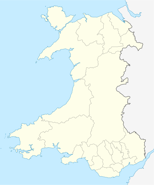
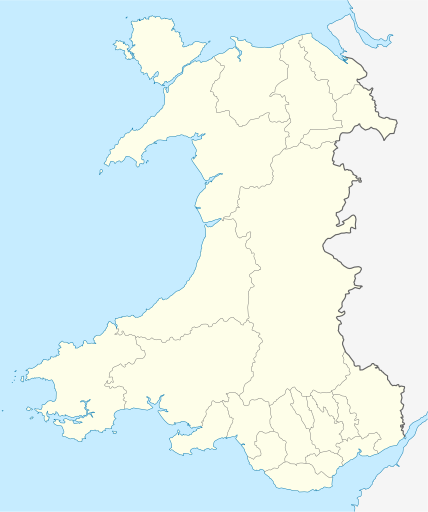
Quadratische Plattkarte, N-S-Streckung 163 %. Geographische Begrenzung der Karte:
Equirectangular projection, N/S stretching 163 %. Geographic limits of the map:
|
| Ngày | |
| Nguồn gốc | own work, using United States National Imagery and Mapping Agency data |
| Tác giả | NordNordWest |
| Phiên bản khác |
Derivative works of this file: |

|
This map has been made or improved in the German Kartenwerkstatt (Map Lab). You can propose maps to improve as well.
|
Giấy phép
[sửa]
Tôi, người giữ bản quyền tác phẩm này, từ đây phát hành nó theo giấy phép sau:
Tập tin này được phát hành theo Giấy phép Creative Commons Ghi công - Chia sẻ tương tự 3.0 Chưa chuyển đồi
- Bạn được phép:
- chia sẻ – sao chép, phân phối và chuyển giao tác phẩm
- pha trộn – để chuyển thể tác phẩm
- Theo các điều kiện sau:
- ghi công – Bạn phải ghi lại tác giả và nguồn, liên kết đến giấy phép, và các thay đổi đã được thực hiện, nếu có. Bạn có thể làm các điều trên bằng bất kỳ cách hợp lý nào, miễn sao không ám chỉ rằng người cho giấy phép ủng hộ bạn hay việc sử dụng của bạn.
- chia sẻ tương tự – Nếu bạn biến tấu, biến đổi, hoặc làm tác phẩm khác dựa trên tác phẩm này, bạn chỉ được phép phân phối tác phẩm mới theo giấy phép y hệt hoặc tương thích với tác phẩm gốc.
Lịch sử tập tin
Nhấn vào ngày/giờ để xem nội dung tập tin tại thời điểm đó.
| Ngày/Giờ | Hình xem trước | Kích cỡ | Thành viên | Miêu tả | |
|---|---|---|---|---|---|
| hiện tại | 13:27, ngày 24 tháng 6 năm 2009 | | 1.047×1.252 (237 kB) | NordNordWest (thảo luận | đóng góp) | {{Information |Description= {{de|Positionskarte von Wales, Vereinigtes Königreich}} Quadratische Plattkarte, N-S-Streckung 163 %. Geographische Begrenzung der Karte: * N: 53.5° N * S: 51.3° N * W: 5.5° W * |
Bạn không được phép ghi đè tập tin này.
Trang sử dụng tập tin
Có hơn 100 trang liên kết đến tập tin này. Danh sách dưới đây chỉ hiển thị 100 liên kết đầu tiên đến tập tin này. Một danh sách đầy đủ có sẵn tại đây.
- User:NordNordWest/Gallery/Location maps
- File:2023 North East Wales National Park (Area of Search) draft map.svg
- File:A470-Wales.svg
- File:All-Wales Orange Map.svg
- File:Anglesey in Wales.svg
- File:Blaenau Gwent in Wales.svg
- File:Bridgend in Wales.svg
- File:Caerphilly in Wales.svg
- File:Cardiff in Wales.svg
- File:Carmarthenshire in Wales.svg
- File:Ceredigion in Wales.svg
- File:Clwyd Preserved County in Wales.svg
- File:Clwydian Range and Dee Valley AONB map.svg
- File:Clwydian Range and Dee Valley AONB stages map.svg
- File:Conwy in Wales.svg
- File:Denbighshire in Wales.svg
- File:Dyfed Preserved County in Wales.svg
- File:Flintshire in Wales.svg
- File:Gwent Preserved County in Wales.svg
- File:Gwynedd Preserved County in Wales.svg
- File:Gwynedd in Wales.svg
- File:Map of Owain Glyndŵr's Revolt.svg
- File:Merthyr Tydfil in Wales.svg
- File:Mid Glamorgan Preserved County in Wales.svg
- File:Mid Wales.svg
- File:Mid and South West Wales Map.svg
- File:Mid and West Wales Fire and Rescue Map.svg
- File:Monmouthshire in Wales.svg
- File:NUTS 2 statistical regions of the United Kingdom 2015 map.svg
- File:NUTS 2 statistical regions of the United Kingdom map.svg
- File:NUTS 3 regions of Wales map.svg
- File:Neath Port Talbot in Wales.svg
- File:Newport in Wales.svg
- File:North East Wales Map.svg
- File:North Wales Fire and Rescue Map.svg
- File:North Wales Map.svg
- File:North West Wales.svg
- File:North and Mid Wales map.svg
- File:Pembrokeshire in Wales.svg
- File:Powys Preserved County in Wales.svg
- File:Powys in Wales.svg
- File:Preserved Counties Wales.svg
- File:Rhondda Cynon Taf in Wales.svg
- File:South East Wales.svg
- File:South East and South West Wales map.svg
- File:South Glamorgan Preserved County in Wales.svg
- File:South Wales Fire and Rescue Map.svg
- File:South Wales Map.svg
- File:South West Wales.svg
- File:Swanline Map.png
- File:Swansea District line Map.png
- File:Swansea in Wales.svg
- File:Torfaen in Wales.svg
- File:Vale of Glamorgan in Wales.svg
- File:Wales AONBs map.svg
- File:Wales AONBs map (with local boundaries).svg
- File:Wales Bridgend.svg
- File:Wales Cardiff Capital Region locator map.svg
- File:Wales Carmarthenshire.svg
- File:Wales Ceredigion.svg
- File:Wales City Regions map.svg
- File:Wales Fire and Rescue Services map.svg
- File:Wales Historic Counties map.svg
- File:Wales Historic Counties map Anglesey.svg
- File:Wales Historic Counties map Brecknockshire.svg
- File:Wales Historic Counties map Caernarfonshire.svg
- File:Wales Historic Counties map Cardiganshire.svg
- File:Wales Historic Counties map Carmarthenshire.svg
- File:Wales Historic Counties map Denbighshire.svg
- File:Wales Historic Counties map Flintshire.svg
- File:Wales Historic Counties map Glamorgan.svg
- File:Wales Historic Counties map Merionethshire.svg
- File:Wales Historic Counties map Monmouthshire.svg
- File:Wales Historic Counties map Montgomeryshire.svg
- File:Wales Historic Counties map Pembrokeshire.svg
- File:Wales Historic Counties map Radnorshire.svg
- File:Wales Map 400 x 478.png
- File:Wales Merthyr Tydfil.svg
- File:Wales Mid Wales locator map.svg
- File:Wales National Parks and AONBs map.svg
- File:Wales National Parks and AONBs map (colours).svg
- File:Wales National Parks and AONBs map (colours and labelled).svg
- File:Wales National Parks and AONBs map (labelled).svg
- File:Wales National Parks map.svg
- File:Wales Neath Port Talbot.svg
- File:Wales North Wales locator map.svg
- File:Wales Pembrokeshire.svg
- File:Wales Powys.svg
- File:Wales Principal Areas Density Map.svg
- File:Wales Principal Areas map (in green).svg
- File:Wales Rhondda Cynon Taf.svg
- File:Wales Swansea.svg
- File:Wales Swansea Bay City Region locator map.svg
- File:Wales Trunk Road Agents map.svg
- File:Wales Vale of Glamorgan.svg
- File:Wales location map subdivisions 1996.svg
- File:Welsh weekly newspapers.jpg
- File:West Glamorgan Preserved County in Wales.svg
- File:West Wales lines Map.png
- File:Wild Wales map.svg
_draft_map.svg)
.svg)
.svg)
.svg)
.svg)
.svg)
Xem thêm liên kết đến tập tin này.
Sử dụng tập tin toàn cục
Những wiki sau đang sử dụng tập tin này:
- Trang sử dụng tại af.wikipedia.org
- Trang sử dụng tại ar.wikipedia.org
- Trang sử dụng tại ast.wikipedia.org
- Trang sử dụng tại az.wikipedia.org
- Trang sử dụng tại ba.wikipedia.org
- Trang sử dụng tại bg.wikipedia.org
- Trang sử dụng tại bh.wikipedia.org
- Trang sử dụng tại bn.wikipedia.org
- Trang sử dụng tại br.wikipedia.org
- Dolgellau
- Bangor-is-y-coed
- Aberaeron
- Patrom:Infobox UK place
- Rhaeadr Gwy
- Llanfachraeth (Mon)
- Trefor (Mon)
- Caergybi
- Aberporth
- Beulah (Ceredigion)
- Llanfihangel-yn-Nhywyn
- Abermaw
- Llan-faes (Mon)
- Ynyslas
- Clynnog Fawr
- Ffair-rhos
- Patrom:Location map Kembre
- Bont Goch
- Gilfachreda
- Parc-llyn
- Pennant (Ceredigion)
- Brongest
- Bryngwyn (Ceredigion)
- Brynafan
- Brynhoffnant
- Coed-y-bryn
- Cwmsychbant
Xem thêm các trang toàn cục sử dụng tập tin này.