File:Hawaii Island topographic map-fr.svg
Jump to navigation
Jump to search

Size of this PNG preview of this SVG file: 728 × 600 pixels. Other resolutions: 291 × 240 pixels | 583 × 480 pixels | 932 × 768 pixels | 1,243 × 1,024 pixels | 2,485 × 2,048 pixels | 3,110 × 2,563 pixels.
Original file (SVG file, nominally 3,110 × 2,563 pixels, file size: 2.11 MB)
Captions
Captions
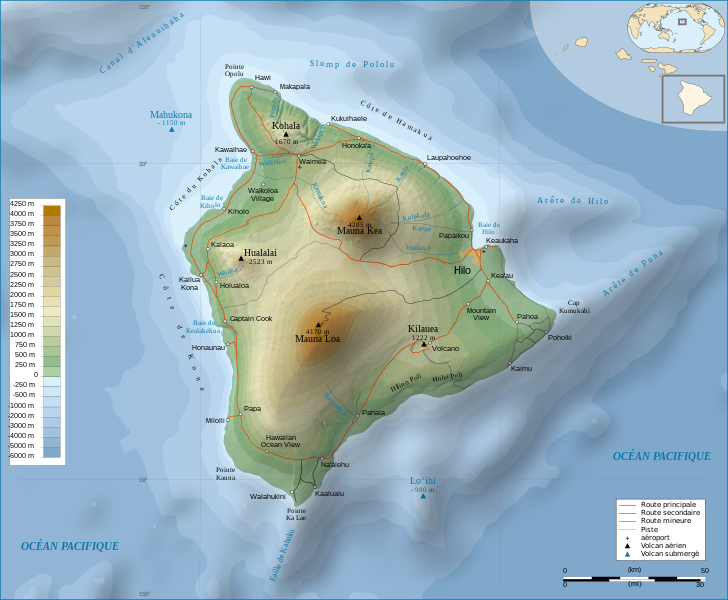
Hawaii Island topographic map
Summary[edit]
| Description | |||||||||
| Date | |||||||||
| Source |
Français : Travail personnel.
Sources :
Logiciels utilisés :
Autres données :
English: Personal work.
Sources:
Software used:
Other Details:
|
||||||||
| Creator | |||||||||
| Georeferencing | If inappropriate please set warp_status = skip to hide. | ||||||||
| Other versions | |||||||||
| Attribution (required by the license) | © Sémhur / Wikimedia Commons / | ||||||||
| Assessments |
|
||||||||
| SVG | W3C-validity not checked.
|
||||||||
| Graphic Lab |


| Camera location | | View this and other nearby images on: OpenStreetMap |
|---|
Licensing[edit]
I, the copyright holder of this work, hereby publish it under the following licenses:
| Copyleft: This work of art is free; you can redistribute it and/or modify it according to terms of the Free Art License. You will find a specimen of this license on the Copyleft Attitude site as well as on other sites. |
This file is licensed under the Creative Commons Attribution-Share Alike 4.0 International, 3.0 Unported, 2.5 Generic, 2.0 Generic and 1.0 Generic license.
- You are free:
- to share – to copy, distribute and transmit the work
- to remix – to adapt the work
- Under the following conditions:
- attribution – You must give appropriate credit, provide a link to the license, and indicate if changes were made. You may do so in any reasonable manner, but not in any way that suggests the licensor endorses you or your use.
- share alike – If you remix, transform, or build upon the material, you must distribute your contributions under the same or compatible license as the original.
You may select the license of your choice.
File history
Click on a date/time to view the file as it appeared at that time.
| Date/Time | Thumbnail | Dimensions | User | Comment | |
|---|---|---|---|---|---|
| current | 12:24, 16 February 2009 | | 3,110 × 2,563 (2.11 MB) | Sémhur (talk | contribs) | Valid SVG |
| 17:31, 7 May 2008 |  | 3,110 × 2,563 (2.19 MB) | Sémhur (talk | contribs) | Route coupée trop courte, je rallonge. | |
| 17:57, 2 May 2008 |  | 3,110 × 2,563 (2.18 MB) | Sémhur (talk | contribs) | Suppression d'une partie d'une route détruite par une coulée de lave | |
| 10:37, 1 May 2008 |  | 3,110 × 2,563 (2.18 MB) | Sémhur (talk | contribs) | New version, with vectorized shaded relief | |
| 18:35, 29 April 2008 |  | 3,110 × 2,563 (1,017 KB) | Sting (talk | contribs) | Slight correction | |
| 18:11, 29 April 2008 |  | 3,110 × 2,563 (1,017 KB) | Sting (talk | contribs) | Added legend | |
| 16:01, 22 April 2008 |  | 3,110 × 2,563 (1,012 KB) | Sémhur (talk | contribs) | Espacement de lettres (oubli) | |
| 08:45, 19 April 2008 |  | 3,110 × 2,563 (1,011 KB) | Sémhur (talk | contribs) | Correction de l'altitude du Mauna Loa et espacement de lettres | |
| 19:04, 17 April 2008 |  | 3,110 × 2,563 (995 KB) | Sémhur (talk | contribs) | Correction d'un problème avec le relief | |
| 18:47, 17 April 2008 |  | 3,110 × 2,563 (996 KB) | Sémhur (talk | contribs) | == Description == {{Information |Description= {{en| Topographic Map in french of the island of Hawaii.}} {{fr| Carte topographique de l'île de Hawaii.}} |Source=Travail personnel. {{clr}} Sources : * Fond de carte : |
You cannot overwrite this file.
File usage on Commons
The following 85 pages use this file:
- Wikimedia Conference Japan 2009/Commons写真展
- User:Aristeas/check
- User:John Cummings/gallerytest
- User:L.Kenzel/Category
- User:Miya/Introduction
- User:Miya/POTY/Diagrams2008
- User:Notafish/Votes 2008
- User:Sémhur
- User:Sémhur/Profile
- User talk:Sting/Archive 01
- Commons:Bu proje sayfasının diğer dil sürümleri
- Commons:Conhece os nossos ilustradores
- Commons:Conoce a nuestros ilustradores
- Commons:Descobreix els nostres il.lustradors
- Commons:Descobrètz nòstres illustrators
- Commons:Découvrez nos illustrateurs
- Commons:Featured picture candidates/Image:Hawaii Island topographic map-fr.svg
- Commons:Featured picture candidates/Log/May 2008
- Commons:Featured pictures/Non-photographic media/Computer-generated
- Commons:Featured pictures/Non-photographic media/Entertainment
- Commons:Featured pictures/Non-photographic media/Exteriors
- Commons:Featured pictures/Non-photographic media/Maps
- Commons:Featured pictures/Non-photographic media/Others
- Commons:Featured pictures/Non-photographic media/People
- Commons:Featured pictures/Non-photographic media/Printed
- Commons:Featured pictures/Non-photographic media/Religion
- Commons:Featured pictures/Non-photographic media/Science
- Commons:Meet our illustrators
- Commons:Meet our illustrators/People
- Commons:Picture of the Year/2008/Galleries/All
- Commons:Picture of the Year/2008/Galleries/Diagrams
- Commons:Picture of the Year/2008/Results/Round 1/Gallery/All
- Commons:Picture of the Year/2008/Results/Round 1/Gallery/Diagrams
- Commons:Picture of the Year 2008/File:Hawaii Island topographic map-fr.svg
- Commons:Potd/2010-02 (da)
- Commons:Potd/2010-02 (de)
- Commons:Potd/2010-02 (nl)
- Commons:Potd/2010-02 (pt)
- Commons:Poznaj naszych grafików
- Commons:Scopri i nostri illustratori
- Commons:Scummigghia ê nostri llustratura
- Commons:Unsere Illustratoren stellen sich vor
- Commons:Unseri Illustratore stelle sich vor
- Commons:Upoznajte naše ilustratore
- Commons:Çizerlerimizle tanışın
- Commons:Запознајте ги нашите илустратори
- Commons:Знайомтесь з нашими ілюстраторами
- Commons:Знакомьтесь с нашими иллюстраторами
- Commons:قابل رسامينا
- Commons:私達のイラストレータをご紹介します
- Commons:结识我们的插图师
- Commons:우리들의 삽화가를 만나보세요
- File:Hawaii Island topographic map-en.svg
- File:Hawaii Island topographic map-fr-vectorized.svg
- File:Hawaii saare kaart.png
- Template:Non-photographic FP galleries top
- Template:Other versions/Hawaii Island topographic map
- Template:Potd/2010-02
- Template:Potd/2010-02-12
- Template:Potd/2010-02-12 (bn)
- Template:Potd/2010-02-12 (bs)
- Template:Potd/2010-02-12 (ca)
- Template:Potd/2010-02-12 (cs)
- Template:Potd/2010-02-12 (da)
- Template:Potd/2010-02-12 (de)
- Template:Potd/2010-02-12 (en)
- Template:Potd/2010-02-12 (es)
- Template:Potd/2010-02-12 (fa)
- Template:Potd/2010-02-12 (fi)
- Template:Potd/2010-02-12 (fr)
- Template:Potd/2010-02-12 (hu)
- Template:Potd/2010-02-12 (it)
- Template:Potd/2010-02-12 (ko)
- Template:Potd/2010-02-12 (mk)
- Template:Potd/2010-02-12 (nl)
- Template:Potd/2010-02-12 (pam)
- Template:Potd/2010-02-12 (pl)
- Template:Potd/2010-02-12 (pt)
- Template:Potd/2010-02-12 (ro)
- Template:Potd/2010-02-12 (ru)
- Template:Potd/2010-02-12 (sv)
- Template:Potd/2010-02-12 (uk)
- Template:Potd/2010-02-12 (zh-hans)
- Template:Potd/2010-02-12 (zh-hant)
- Template:Potd/2010-02 (zh-hans)
File usage on other wikis
The following other wikis use this file:
- Usage on af.wikipedia.org
- Usage on ar.wikipedia.org
- Usage on bn.wikipedia.org
- Usage on crh.wikipedia.org
- Usage on cv.wikipedia.org
- Usage on en.wikipedia.org
- Usage on eo.wikipedia.org
- Usage on es.wikipedia.org
- Usage on eu.wikipedia.org
- Usage on fr.wikipedia.org
- Analogique
- Mauna Kea
- Mauna Loa
- Utilisateur:Sémhur
- Hawaï (île)
- Hualālai
- Discussion aide:Cartographie
- Discussion Wikipédia:Wikiconcours/mars 2008/Équipes/Équipe 5
- Projet:Impression/Wikigraphistes
- Utilisateur:Sémhur/Récompenses
- Wikipédia:Image du jour/juin 2010
- Wikipédia:Image du jour/16 juin 2010
- Kohala (volcan)
- Cap Kumukahi
- Phare du cap Kumukahi
- Discussion Wikipédia:Atelier graphique/Archive 10
- Usage on fr.wikinews.org
- Usage on hu.wikipedia.org
- Usage on id.wikipedia.org
- Usage on it.wikipedia.org
- Usage on ko.wikipedia.org
- Usage on krc.wikipedia.org
- Usage on lbe.wikipedia.org
- Usage on lv.wikipedia.org
- Usage on mg.wikipedia.org
- Usage on mk.wikipedia.org
- Usage on mt.wikipedia.org
View more global usage of this file.