This is an archive of past discussions. Do not edit the contents of this page. If you wish to start a new discussion or revive an old one, please do so on the current talk page.
More cities under aerial bombardment/missile strikes
Bila Tserkva
Please, add w:Bila Tserkva. It was bombarded multiple times with missile strikes. Particularly, a military base, a dormitory, an oil depot and a civilian area were the targets/casualties.
In the current color scheme, the arrows representing Ukrainian advances are barely visible. If one does not want to change the color scheme, an outline should be added to the arrows Fgrosshans (talk) 08:19, 24 March 2022 (UTC)
Agree. In theory, this map is based on the detailed map, which in turn is based on the Control of cities page. In fact, the three are inconsistent. We could make the detailed map and the Control of cities page consistent by having them both rely on data in the same Lua module, but that would raise the level of skill needed to make an edit, and wouldn't solve the problem for this map. In addition, it can be difficult to find reliable, up-to-date information regarding the control of cities with a population below around 70k, which causes ambiguity which can be difficult to resolve: for example, if one side captures all the cities surrounding such a town, but there's no way to tell who controls the town, how do we treat the town and its surroundings on this map? This scenario describes the situation we have with Beryslav. —AlphaMikeOmega (talk)22:58, 21 March 2022 (UTC)
It can stay on Commons without a data source, but if we want it to be usable on other projects, we'll need to provide some sense of where the information is coming from. I support AlphaMikeOmega's procedure in #The latest map is outdated. Does Commons have some way to set up an edit notice to explain how to properly source updates to the map? ― Tartan357Talk08:20, 25 March 2022 (UTC)
I am from de-WP and do not know anyone here. Maybe admins could help, but it would be helpful to have much more attention on this map in general. I tried tagging, but no one really seems to care.--Iconicos (talk) 10:44, 24 March 2022 (UTC)
25.03 Ukraine libarated Trostianets. Also areas beetwin Sumy and Romny (Stepanivka, Nedryhailiv) under ukrainian control. Sumy, Lebedyn, Okhtyrka are not contested, but under Ukrainian control. Make changes someone please. --Olmi (talk) 08:28, 26 March 2022 (UTC)
okay well make sure to list your sources next time as there needs to be evidence of a claim to have it effect the map also the second source about trostianets is a clearly biased ukrainian facebook page and isnt a reliable source i cant speak to the other one you provided Fireduck420 (talk) 10:21, 26 March 2022 (UTC)
The bottom right leads the viewer/reader to believe that the dashed line represents current frontlines. Of course, its a generalization based off of approximation of troop positions. Regardless of how obvious this may be, I believe that the caption for the dashed line on the legend should read 'Approx current frontlines' or something of this nature. Thanks, Mebigrouxboy (talk) 16:24, 27 March 2022 (UTC)
Still need help with how to be able to edit this map
Would you be so kind as to explain to me how I can edit the Ukraine invasion map I can’t find a editing button. Thank you BigRed606 (talk) 05:02, 28 March 2022 (UTC)
The latest map is outdated
According to it, a large portion of Mykolaiv Oblast is under Russian control, as well as the settlements of Yavkyne and Snihurivka. It also states that those are the advances from March 9th, but starting from March 17th, there was a successful Ukrainian counteroffensive which pushed the Russians back all the way to Posad-Pokrovske at the border with Kherson Oblast. There is video evidence of that. Furthemore, more evidence surfaced of destroyed Russian equipment south of Snihurivka, meaning that it is likely that the counteroffensive was successful there too. I believe it should be updated. — Preceding unsigned comment was added by 79.140.150.67 (talk) 05:12, 19 March 2022 (UTC)
This map is massively wrong and outdated. See here. It is frequently uploaded by an obviously Russian user. Wikipedians should watch out that it's not subject to misinformation or worse.--Iconicos (talk) 14:24, 22 March 2022 (UTC)
The map on that website is outdated too especially in the north where it still shows Konotop as Ukrainian and has no siege around Chernihiv. Eggonegg (talk) 14:40, 22 March 2022 (UTC)
This is no reason to have an outdated and wrong map in the south and other locations. The map should be updated or deleted to avoid misinformation.--Iconicos (talk) 15:29, 22 March 2022 (UTC)
Which proof is there that Russian control still includes M7 motorway and the vicinity of Malyn? And is there still fighting in Byshiv? (Both towns in Kyiv region.) Liveuamap has significant differences there. Also the front line near Mykolaiv needs to be clarified and proven with clear references here on the talk page, please.--Iconicos (talk) 17:02, 23 March 2022 (UTC)
User:Eoiuaa has reverted tagging of the map as "outdated" for the reason that European and American sources were not reliable in his opinion. But Russian military sources or other claims are? I think this map is under strict control of Russian accounts. Admins should take care of this problem, as this map is used in worldwide Wikipedias.--Iconicos (talk) 10:22, 24 March 2022 (UTC)
I repeat once again that you cannot rely ONLY on a Ukrainian and American source. You need to compare the information and only then change the map. We cannot change the map with the slightest change on liveuamap... Eoiuaa (talk) 11:47, 24 March 2022 (UTC)
"Slightest change"? There are massive differences to liveuamap and other reliable sources covering the events. It is obvious from denying any reliability of American (or other than Russian) sources that you do not accept the basic guidelines of Wikipedia. Admins should decide what to do with this.--Iconicos (talk) 12:59, 24 March 2022 (UTC)
Well, but who said that we publish the map based on a Russian source? I consider this an unjustified accusation. If you think that there are changes, I advise you not to quarrel over each change, but to change the map yourself;) Eoiuaa (talk) 13:41, 24 March 2022 (UTC)
I have no interest in any quarrels, not with web brigades, not with other trolls, so I suggest to leave it outdated until the differences become so striking that not even you can deny it. ;)--Iconicos (talk) 14:29, 24 March 2022 (UTC)
Sorry but also the institute for the study of war, which to me looks like probably the most reliable sourse so far presents a very similar map to the one posted. I don't think there is any control on this file of any russian propaganda, and also so far the russian controlled area depicted in the map have been very conservative with respect of russian claims so i don't think there's any problem there. Furthermore i would like to point out that actually in theese days russian information about control of territories seems to be just more accurate (i say this on my own following of the situation). Liveuamap on the other end shows the entire noerheast as ukranian controlled while all other sources including the institute for the study of war show them as russian controlled ("assessed" so they claim to have reliable sources) and some of them where on the history of updates of this map. Then there is Konotop that i don't know how can be claimed as ukranian control while it is under russian control from the first days and it has been assessed very times. Unfortunately today the map that we would like to prefer is not the most accurate one and we should seek to build a true one instead. Ele piloni krati (talk) 18:32, 24 March 2022 (UTC)
@Iconicos, you can't assume that everybody is a "Russian account" just because someone is changing a map that goes against what you believe in. Can you please explain to me why are you cherry picking parts of the liveuamap.com? Ignoring that it extremely conservative and outdated? You ignore the part that liveuamap.com is unreliable, showing that Konotop is under Ukranian control, Chernihiv not under siege, and Shostka under Ukrainian control. You only see what you want to see. Liveuamap.com is ONLY a reliable source for airstrikes. Besides that, it is just as biased as Russian claims. It was created and is controlled by twopro-Ukranians. Just because liveuamap, says that some regions are controlled by Ukraine, it's not guaranteed that they indeed are. Gaeilge181 (talk) 19:20, 24 March 2022 (UTC)
@Eoiuaa is right that we shouldn't simply copy from liveuamap, the reasons being here. What liveuamap is useful for is its links to sources which may be reliable enough for us to also use. That said, a lot of their sources are tweets which are not easily verified. Another option is to look up towns near the front line on a search engine, and see whether there is news reporting on the control of these towns.
That said, @Iconicos is right that Eoiuaa has been using Russian government sources, for instance for versions 09:52, 22 March 2022 and 17:12, 22 March 2022. Again, the policy of not quoting the governments of belligerents (except perhaps for when they concede their own setbacks) is given here. This also means that if a reliable source quotes one or other belligerent, as opposed to independently confirming the situation on the ground, then the quote cannot be used to change the map.
The correct (or, at least, best) procedure when updating this map is to
If your source independently confirms control of a city, or is a quote from a belligerent (or any other biased source) conceding a setback, edit the "Control" column and proceed to (4.).
If your source states that a side claims to have control, but this is not independently verified, add this to the "More information" column. Do not proceed to later steps, i.e., don't edit any maps based on this source.
Obviously, do not replace a more recent reference with a less recent one.
One result of this procedure is that if you need to put URLs in the changelog, you're doing it wrong. I don't want to single anyone out in particular, because a lot of editors have been doing this. But we shouldn't.
Finally, ISW is listed as one of the two sources regarding territorial control. This means that the text of their updates can be used as a source, but, in a similar vein to liveuamap, their maps cannot be. Because the ISW's updates aren't all on a single webpage, I recommend against using it directly as a source, and instead recommend following the procedure described above. —AlphaMikeOmega (talk)19:15, 24 March 2022 (UTC)
Thank you, AlphaMikeOmega, for establishing this clear procedure. All, please watch that everything is done according to it. We should not be naive which conflict party does what to exert influence on the narrative of this war. And thank you for the changes near Mykolaiv. Still, situation around Kyiv on the map is as far from reality as it could be. The map is still absolutely outdated there.--Iconicos (talk) 08:38, 25 March 2022 (UTC)
No, they were unsourced and wrong. Not even the Russian defence ministry makes such claims, see discussion below (under "Funny"). And you are edit warring.--Iconicos (talk) 11:35, 26 March 2022 (UTC)
@Iconicos, just see the detailed map as it was agreed to be used as a source. You will see that Shostka and North West Kherson Oblast are under Russian control. You are not following procedures. Gaeilge181 (talk) 13:28, 26 March 2022 (UTC)
Gaeilge181, you are not only doing what you are describing in your edit comment; you do massive further changes which are not backed by any map, and, foremost, not even by the Russian ministry of defense. You know that, and you know that you are edit-warring. Chernihiv is not encircled, which can be found in various sources. See here: [9]--Iconicos (talk) 13:34, 26 March 2022 (UTC)
3rd block. I hope everyone has read the note of the admin: "ANY ACCOUNT EDIT-WARRING OR ADDING UNSOURCED VERSION WILL BE BLOCKED ON SIGHT. ANY CHANGE SHOULD BE DISCUSSED ON THE TALK PAGE." So every change shall be discussed here from now on. Thank you.--Iconicos (talk) 13:54, 26 March 2022 (UTC)
What do you think of adding this message? Whether you think it should be added, what changes would you make to it before it were added?
Rules for editing the map
A reliable source for that specific edit should be provided.
A well-known source that has a reputation for neutral (not biased) territorial control coverage can be used (is deemed reliable) for all edits.
A well-known source that does not have a reputation for neutral (not biased) territorial control coverage, can be used (is deemed reliable) only for edits that are unfavorable to the side it prefers (favorable to the side it opposes).
A source that is not well-known (or that has proven inaccurate for all edits) cannot be used (is deemed unreliable) for any edit. This includes all maps (see item 2. next).
Maps from mainstream media are approximate and therefore unreliable.
Maps from amateur sources are unreliable. (On Wikipedia, they would violate w:WP:SPS and w:WP:CIRCULAR.)
The ISW's maps (provided among this file's list of sources) may be used when determining what land is controlled only outside settlements. If you wish to use another map, discuss it on the talk page and, if it is deemed useful and reliable, add the map to this file's list of sources and update this message.
Seems good. Maybe we should add that changes have to be always discussed on this talk page, as the admin here decided. --Iconicos (talk) 10:57, 27 March 2022 (UTC)
I want to add one question, as the page is currently blocked. Who is able to edit the map right now and who has rights for uploading it? We should establish a procedure and find users who are able to help out and get the updates done.--Iconicos (talk) 11:00, 27 March 2022 (UTC)
Ok, I learned from the page history that upload and editing of the map is possible for all autoconfirmed users again since yesterday. @User:AlphaMikeOmega, please put your message on the front page. @User:Viewsridge, @User:Artemis Dread, could you please help to update the map according to the procedures? Thank you very much.--Iconicos (talk) 09:58, 28 March 2022 (UTC)
Relability of map
For several weeks, this was one of the more reliable maps available on the conflict. But now it simply seems to just reflect whatever ISW says. There was value in the map when it was reflecting a multiple point of view sort-of consensus. But at this point, it would be better to just duplicate the ISW maps and stop pretending that there is any value add in this map. 98.144.25.18120:44, 26 March 2022 (UTC)
For several weeks this map was edited using such ‘reliable sources’ as Telegram channel of a pro-Russian guy who’s been charged by Latvian authorities for treason. Is that what you call ‘multiple point of view’? Outth (talk) 07:51, 27 March 2022 (UTC)
It's my first time ever commenting in a discussion, and I consider myself an "external" and "neutral" user (viewer) of Wikipedia content's. I am not pro-Ukriane nor pro-Russia, I have only a general interest in following the details of the conflict and its development. So please take my opinion as the point of view of a "casual" user who relies on Wikipedia supposed "neutrality" to get informations.
That said, it appears to me that this map is just another battlegroud for the two sides. The way it is updated only reflects the alternations of two biased point of view trying to be the right one. One update is pro-Russia, the next one is pro-Ukrain, and so on. This is not what I expect to find on Wikipedia.
Fully agree Outth. Users may also add Russian advances as well as Ukrainian, but only using good sources. And not by POV-pushing and edit-warring, as done here by Pro-Russian accounts. 4 of them are blocked now, and rightfully so.--Iconicos (talk) 10:53, 27 March 2022 (UTC)
There’s indeed some inaccuracies, a number of both Russian and Ukrainian advances have not yet been added to the map Outth (talk) 16:33, 27 March 2022 (UTC)
Regarding Chernihiv, see w:Battle of Chernihiv. There is a difference if it is cut-off (because of the Southern bridge of the city destroyed) or fully encircled by troops. ISW said on Friday, it is not fully encircled, as written in the article.--Iconicos (talk) 12:56, 28 March 2022 (UTC)
And it's still not clear, if Northern Ukraine is under Russian control. Some citys and towns might be simply bypassed or left again by Russian army. Please also note the map by the Russian defence ministry in the section "Funny" above.--Iconicos (talk) 11:06, 28 March 2022 (UTC)
I provided 2 reliable sources for proving that Northern Ukraine is under Russian control. I provided Al-Jazeera and AFP. The map should be changed accordingly. 106.214.118.20113:02, 28 March 2022 (UTC)
Please consider the procedure above as just linked here: "Maps from mainstream media are approximate and therefore unreliable." --Iconicos (talk) 13:06, 28 March 2022 (UTC)
Still, they also depend on mainstream media sources so why they can't be used here? Can you describe why you made this revert? It was a good improvement by User:Noehtahir which was in fact resolving the concern I raised here. 106.214.118.20115:53, 28 March 2022 (UTC)
I linked the discussion above for you. The note of the admin says: "ANY ACCOUNT EDIT-WARRING OR ADDING UNSOURCED VERSION WILL BE BLOCKED ON SIGHT. ANY CHANGE SHOULD BE DISCUSSED ON THE TALK PAGE." The user's edit btw contained massive unexplained and unsourced changes in all parts of the country.--Iconicos (talk) 15:58, 28 March 2022 (UTC)
Why is there no russia advances toward Krivyi Rih?
Some sources from NYTimes, Telegram, Yandex.ru, glas.ru and 19rusinfo stated that there is a fight 10 kilometers away from Krivyi Rih, Krivyi Rih's Major Alexander Vilkul said.[[1
And again regarding the reliability of sources: the source you’ve mentioned is in general pro-Russian and thus not neutral. — Preceding unsigned comment added by Outth (talk • contribs) 16:29, 27 March 2022 (UTC)
Hi @User:Iconicos, motorway Borodianka-Malyn, Byshiv, Makariv - done. Brovary and surroundings — I don't know how to implement it technically yet. If anyone has the skills to do this, please contribute.--Artemis Dread (talk) 13:43, 28 March 2022 (UTC)
One addition here: Vyshneve and Shevshenkove are not under Russian control, they probably never really were. w:Battle of Kyiv (2022) only says, that there was shelling in Vyshneve by the Russian army, not that it was captured. The frontline is more to the North, at M-06 motorway.--Iconicos (talk) 14:25, 29 March 2022 (UTC)
The Russian army did not approach the Vyshneve. The map shows only Shevchenkovo in red. I don't have any information about this village.--Artemis Dread (talk) 14:43, 29 March 2022 (UTC)
All of them are weak sources. Shostka: The source - only an eyewitness report - makes no claim that Russian troops control the city. See also w:Battle of Shostka, no source reports direct control. What I read about it is that the Russians may have some checkpoints outside. Seems similar to what they did after the w:Battle of Konotop (2022). I also doubt Krovelets, [13] doesn't show it as occupied and your source only says, the Russians came along the highway, not that they are inside the town which is North of the highway. Also Hlukhiv is not shown as occupied, might be similar situation. So I agree to show Borzna, Bakhmach and Baturyn under Russian control for now. If somebody wants to change just that, go ahead. (And if I may add that, regarding your headline, desperation is in many places in Ukraine these days. For peace.) --Iconicos (talk) 18:19, 28 March 2022 (UTC)
Thank you, good addition. Obviously they let the Ukrainians in control in some of the towns up there, just passing by in Kyiv direction.--Iconicos (talk) 18:34, 28 March 2022 (UTC)
The map shown during the Russian briefing shows an even larger area without Russian control. Maybe it's worth discussing? — [17] --Artemis Dread (talk) 13:29, 30 March 2022 (UTC)
The problem of understanding the relevance of the update
Could you write the date of the information update directly on the map?
It is constantly not clear how relevant the information is, you have to go to the image section and watch its history. — Preceding unsigned comment was added by 2.135.66.224 (talk) 18:38, 28 March 2022 (UTC)
But in this case, you still have to enlarge the map, plus look for the very last arrow all over the map, among hundreds of arrows. This does not make it easier to find the date at all, it is much easier to go into the file's modification history (which I don't like). 92.47.57.14515:45, 30 March 2022 (UTC)
Failure to source properly
we need to provide sources whenever we make changes to the map and ideally provide them next to the edit or in a clear place
also as per previous war maps on Wikipedia, we cant take Ukrainian sources at face value the only time you take a pro-Ukrainian source or pro-Russian source at face value is when it shows them losing territory or in a negative light
there is a Wikipedia list of biased sources that would helpful when deciding if a source is biased or not — Preceding unsigned comment added by Fireduck420 (talk • contribs) 10:58, 30 March 2022 (UTC)
Read the procedures and stop edit-warring, please. Sources should be put to w:Control of cities during the Russo-Ukrainian War. @Artemis Dread, please explain your edits. To my knowledge it's correct that Ukraine regained territory east of Kharkiv (Mala Rohan). But is it that much? At least Pechenihy should be marked as contested. The other edit were small corrections.--Iconicos (talk) 11:47, 30 March 2022 (UTC)
I relied on w:Control of cities during the Russo-Ukrainian War as on the declared source of the map. This map shows the entire southern gap near Kharkov controlled by Ukraine. If this card is not correct - refer to its talk page. However, the Kharkiv-Chuguev road is definitely under Ukrainian control — [15] - local source, [16] - BBC.
Regarding Snovsk, I wrote to them on the talk page. On the map during the Russian briefing, it was marked as out of control — [17]. Ukrainian sources also confirm this — [18]. What's wrong with Kozelets?--Artemis Dread (talk) 12:42, 30 March 2022 (UTC)
Thank you, nothing wrong with it, I just wanted to make it clear that it's correctly marked as Ukrainian. Just mark Snovsk as Ukrainian and Pechenihy as contested, please.--Iconicos (talk) 12:48, 30 March 2022 (UTC)
I’m starting this separate section in hope to facilitate proper map editing with discussion on each change. Everyone is welcome to add their proposals, comments, sources etc.
As of now (27 March 2022, 17.00 UTC) changes that are not yet reflected on the map:
- Slavutych in Chernyhiv region is under Russian control - questionable
- Trostianets in Sumy region is under Ukrainian control done
- Snehurivka in Mykolaiv region is under Ukrainian control No, still Russian control according to ISW
also Irpin is under Ukrainian control according to its mayor (don’t know if it could be considered as a reliable source) done Outth (talk) 13:59, 28 March 2022 (UTC)
hi; do we have proper confirmation of these big changes around kyiv? (& are we remembering that today is april 1st...?) Lx 121 (talk) 18:50, 1 April 2022 (UTC)
Hello, as per this discussion, it looks like fighting has now spread to Russian territory (while remaining a part of the "invasion" conflict). Given this, it might be prudent to expand the area of coverage to include Russian border regions so that we are not missing conflict information. 82.15.196.4615:57, 1 April 2022 (UTC)
What is the principle of filling areas?
And on what basis are the areas painted over? Who is responsible for issuing the card? How do people determine where the whole area needs to be painted over, and where only small roads? 95.59.45.23917:49, 1 April 2022 (UTC)
re: arrows
could we get dates on the movement arrows maybe, or something else to show the timing? (please & thank-you) because it is starting to turn into a confusing mess without them... (& as events go on, it's going to get more & more crowded) & perhaps (also dates) on the old/past/former "frontlines"? Lx 121 (talk) 19:25, 1 April 2022 (UTC)
i see some of them do have dates (my apologies! could not read them, vaguely thought they were army-unit info); but even @ full-size, the text is too way small to make out & the colour contrast isn't great (laptop here) Lx 121 (talk) 01:51, 2 April 2022 (UTC)
North- above Kyiv
Plwase can someone update the offensive above/to Kyiv?
Parts of the map are not up to date especially the North eastern areas. For example In Northeastern Ukraine offensive on Wikipedia, it says that “ Russian forces capture Konotop and Shostka, but on the map it show Shostka as being under control of the Ukrainians. Multiple reliable sources such as the BBC and CNN show that the region I just mentioned above is in control by the Russians. Indeed the map was correct up until the last two weeks when a consensus was shown that somehow the north eastern region was actually still controlled by the Ukrainians.
I'm with you, unfortunately now a lot of people here on the discussion seems to disregard facts and news which do not favour their personal preferred view of things, i say it because i used this map to keep myself updated on the situations but no longer can. To me it seems that politics is at play also here were it should not and it is just a bad sight to behold. The premises of the edits were to allign the map to the page https://en.wikipedia.org/wiki/Control_of_cities_during_the_Russo-Ukrainian_War but it still don't. Sources are now cherrypicked on what they say instead of the author and they keep the map like this ignoring that any reliable media has staded that the northern east is under russian control (including al jazeera, bbc, cnn, ISW, and direct news that were posted on the original map updates from people living there). I think this map is showing one of the worst side of politics use on wikimedia. Ele piloni krati (talk) 07:50, 31 March 2022 (UTC)
Would you mind to read procedures and discussions above like "Northern Ukraine is under Russian control" or "North-east Ukraine in desperate need of update"? And please don't discuss the same issues for the 2nd and 3rd time? Thank you.--Iconicos (talk) 09:09, 31 March 2022 (UTC)
We are discussing it for the third time because the sources are utterly disregarded and because It is blatantly clear that shotska and the northeast is under russian control while here some rules are being used that should make the map different while it still is not. It is clear to me that you and some other editors here are politically biased and are trying to put politics over the state of the matter. Explain me why sources are disregarded and the ISW map is treated as a piece of fanfiction while UAlivemap is used as the gospel. Fortunately it seems i am not the same with this belief here. Ele piloni krati (talk) 06:21, 1 April 2022 (UTC)
Totally agree. This map only uses unreliable sources. Besides that, it’s also not using the sources that were claimed to be used (ISW and the detailed map), which shows a totally different map, especially in the Northeast. This map was very good and not biased until a week/two weeks ago Muteten (talk) 20:51, 31 March 2022 (UTC)
The map was largely made by now blocked pro-Russian accounts. And you wouldn't write that if you read the discussions I listed for you or looked into the detailed sources. Several towns in the North East are only blocked, not taken by the Russians, this is what the sources say. They were just passing by on their way to Kyiv. Also read w:Battle of Konotop (2022) and notice what happened there. There is no Russian control in most of the towns. We won't prefer a generalizing map to detailed sources.--Iconicos (talk) 09:45, 1 April 2022 (UTC)
Please do not use the blocks to support your opinion. Even the admins cannot explain the reason of those blocks. See here. I do not like to join your annoying pro-Russian/Ukrainian argument. But it is against the rules to push someone into this kind of situation. And the word you used in the discussion of last week, like "web brigades", "trolls" and "cyberwarriors", might also cause a block to you. You should be thankful that the admin were biased or were too busy to see your breach of the rules.Wo.luren (talk) 18:03, 2 April 2022 (UTC)
This map is like a dictatorship, no one can say things that go against @Iconicos’s point of view. I seriously don’t get how he’s not banned Muteten (talk) 19:29, 2 April 2022 (UTC)
The whole railway from Kharkiv through Bohoduhiv and Sumy to Bilopillya is under control of Ukraine, there the railway connection is already restored. [20] Train timetable from April 2. From Bilopillya to Sumy and Trostyanets [21] --Olmi (talk) 14:46, 1 April 2022 (UTC)
splitting?
& maybe we should consider separating & splitting off a "history of events" map, from a "current situation right now" map...? Lx 121 (talk) 19:35, 1 April 2022 (UTC)
no, i mean a map, for end-users, articles, etc. that shows the history of movements, front lines, etc.
& separately, a map that shows the current/up-to-date state of affairs "right now", without being cluttered up with the history of previous actions.
also; the edit history has a lot of disputed edits, so that makes it a lot less clear as a timeline of real events on-map. Lx 121 (talk) 22:27, 1 April 2022 (UTC)
If you're talking about this, there's an animated version (which doesn't even go far but it's something at least). Dawsongfg (talk) 02:00, 3 April 2022 (UTC)
I have the most common form of color deficiency (green-weak), which afflicts something like 10 percent of men in the world. The map in the main box is utterly useless, using two colors that look identical to me.Acsenray (talk) 19:02, 1 April 2022 (UTC)
This is to ensure there will be no confusion on which events were counteroffensives/retreats and which events were withdrawals. The current map makes it look like the UAF just launched some massive counteroffensives when it was Russia who announced and performed a withdrawal since 30th March, however the fact is that the UAF did not have to fight for much, if any, of the places they have regained, most of it they have entered 3-4 days after the Russians have withdrawn. There is also no evidence that there are any massive troops movements from the UAF to show that this was a counteroffensive, most of the regaining seemed to be carried out by minimal to no troops at all. There is thus a need to reflect this situation properly until there are other evidences that shows otherwise.
These areas should not be marked as Ukrainian counteroffensives with yellow arrows, retaking land after the opposing side withdraws is NOT an counteroffensive. These cases should be marked with a red arrow going in the direction of retreats to prevent misleading readers into thinking that the UAF actually fought and retook the areas. — Preceding unsigned comment was added by 103.6.150.129 (talk) 07:34, 2 April 2022 (UTC)
It's not only withdrawal according to ISW: "Ukrainian forces retook substantial territory both northwest and east of Kyiv in the past 24 hours. Ukrainian forces likely advanced faster than Russian forces anticipated, but Russian forces successfully withdrew much of the damaged combat power remaining around Kyiv into Belarus." [22] So it's correct to show yellow arrows.--Iconicos (talk) 09:16, 2 April 2022 (UTC)
I'm not talking about particular events, I'm talking as a whole. Also I wouldn't treat the ISW as an authority over this event. They have just made baseless claims again and again, just today they declared that "capturing Kiev" have always been Russia's plan without any evidence. Nebakin (talk) 12:56, 2 April 2022 (UTC)
If there are only two sides in a war, it's a zero sum game. One side withdraws or capitulates = the other side advances. That's well within the definition of an offensive or counteroffensive. 80.62.29.14312:45, 2 April 2022 (UTC)
Nope, realising your opponent have withdrawn and you reclaiming without a fight is NOT an counter-offensive. Nebakin (talk) 12:59, 2 April 2022 (UTC)
If it is not a counter-offensive, why the hell did the Ukrainian Army found so many working Russian equipment and dead Russian soldiers? Was it part of the Russian retreat to kill some of their own troops and to leave some presents for Ukraine? Dude, look at the facts, the Russians didn't withdrawn, they retreated out of a meat grinder. And they were standing in the meat grinder for 40 days, because they wanted to encircle>capture Kiev. It failed. The retaking of these areas with clean-ups of the Ukrainian Army is a Counter-offensive for the Ukrainian side. The Russian side don't want to see it as an offensive and claims to withdraw to keep their face.
The actual pro-Ukrainian viewpoint would be to claim, that Russia had to withdraw all his troops, not even leaving some defensive troops, because they were not even able to hold captured parts of Ukraine in this area against the Ukrainian efforts to retake these areas. I'm not supporting this claim, but i don't support the claim of Russians of a withdrawn as well. It was an offensive and a counter. Troop moved in these directions.--2003:DF:A74B:1E32:8014:E567:F3BD:EFBB01:17, 3 April 2022 (UTC)
It's not an counteroffensive at all. The UAF DOES NOT have any capabilities to even force back the Russians from N.Kiev, much less "clear them out" in 4 days. The Russians have been leaving since 30th March at least, that IS a withdrawal, not a retreat. The UAF ONLY went in AFTER the Russian troops are gone, that is NOT a counteroffensive. Russians left Bucha on 30th march, but UAF only arrived on 2nd April, is that what you call a counter offensive? Taking over empty towns?
Please stop claiming Russian wanted to capture Kiev, where did Russia announce that? Prove it please. Anyone who knows what they are talking about can clearly seen Kiev is a pressuring move to hold UAF troops in place. Also stop with the nonsense of "why did UAF found so many Russian equipment", if you are truly looking at sources from both sides you will find that pro-Russian sources provide the same amount, if not even more proof, of abandoned/destroyed equipment, dead UAF soldiers and POWs. Nebakin (talk) 02:22, 4 April 2022 (UTC)
"Please stop claiming Russian wanted to capture Kiev, where did Russia announce that? Prove it please. Anyone who knows what they are talking about can clearly seen Kiev is a pressuring move to hold UAF troops in place." I think you've been playing too many video games. 82.44.121.23415:38, 4 April 2022 (UTC)
According to your logic, Germany didn't have an offensive into Czechoslovakia in 1938 when the Munich conference ordered the Czechs to stand down and the Germans occupied the Sudentenland. Or similarly when Germany advanced all over Denmark in two-three days after Denmark capitulated on 9 April 1940. In World War 2, the Soviet army took Vilnius in 1944 without serious fighting because the German army there had collapsed. In any literature I've seen, those were all offensives. This Ukrainian advance is exactly the same, an offensive. 80.62.29.14307:37, 3 April 2022 (UTC)
You used 2 false analogy. 1. Standing down =/= withdrawal. 2. Vilnius was part of a larger actual offensive with actual fighting.
UAF was retaking over empty towns with drive-thrus 3-4 days after the Russians have withdrawn completely with minimal troops, that is not a counteroffensive. Nebakin (talk) 02:23, 4 April 2022 (UTC)
You insist that the thing that qualifies as an offensive is glorious combat between armies and anything else is not an offensive. That's your opinion not a fact. I'm sure Russian media didn't have trouble recognizing the Russian airbone troops landing at Kyiv's airports in the beginning of the war as an offensive military action even if those airports were very sparsely defended by the Ukrainians if defended at all. By your logic only the Ukrainians annihilating those invading units was an offensive not the Russian act of attacking those areas. My examples were fine, you just don't like them because you've already made up your mind. "Vilnius was part of a larger actual offensive with actual fighting.", so it was part of a larger war. Exactly like these movements are part of a larger war, this is all the closing part of the 2022 Russian attack on Kyiv. 80.62.29.14306:57, 4 April 2022 (UTC)
Comments on the recent image-warring
Really?? Of all the files to image war over, you guys have to pick THIS IMAGE, the main image used for the Russian invasion of Ukraine, and also an image with extremely high visibility??? The image wars I've witnessed over the past couple of weeks alone has been completely ridiculous, especially the image war in late March, which resulted in an administrator locking up the page for days. Get it together. To other users like myself, and to outside observers, this perennial image-warring appears extremely childish and makes us look incompetent. Knock it off. It's ridiculous that this file has seen so much edit-warring, especially since it resulted in inaccurate revisions getting locked in on numerous occassions. LightandDark2000 (talk) 16:02, 4 April 2022 (UTC)
Also, the map should be following the Wikipedia map module more closely, as it is edited using reliable sources. The situation in southeastern Ukraine in the Commons map is clearly outdated, as is part of northeastern Ukraine. LightandDark2000 (talk) 16:02, 4 April 2022 (UTC)
Hi,
I think this version is also outdated, can you please edit the image to follow the template more closely (such as showing Konotop being recaptured by the Ukranians)? Also, what are you using to edit the map?
The version you linked is no longer the latest revision. The latest revision, as of this writing, is this version. Try refreshing your browser, or clearing your cache. As for the software used to edit this map, I'm personally not one of the editors, but I believe that an SVG maker, such as Inkscape, is being used. LightandDark2000 (talk) 19:12, 4 April 2022 (UTC)
Calm down, please. I think the current version (03 April, 23:32, someone just reverted again...) is quite reasonable and largely matches the current situation. Details can be adjusted starting from this version. If you feel annoyed by conflicts, why don't you help to solve them as others did? Complaining is easy. Furthermore, the file was only blocked one day. After that work on the map resumed in a fairly good manner.--Iconicos (talk) 20:27, 4 April 2022 (UTC)
Agreed, current version shows the Russian withdrawal from Sumy oblast is well-progressed, while the Kharkiv oblast frontlines, along with the eastern and southern fronts, are likely to be virtually static in the immediate future. Culloty82 (talk) 21:12, 4 April 2022 (UTC)
How could the ISW report be 3 years old? The conflict only began a little over a month ago. Anyway, the latest ISW update shows that the Ukrainian forces have taken back all of the occupied areas in the Kyiv Oblast. Physeters (talk) 03:13, 4 April 2022 (UTC)
Changed the map based on the map on liveUAmap.com. And also on tweets and sources attached to the map on the same site.
Added both Ukrainian and Russian offensives and fronts with dates, edited fronts near Izium, Konotop, Shostka, Chernigov, Volnovakha and Vuhledar. (All this based on liveUAmap.com).
I made a separate topic for updates (and there are a lot of them), so that you can write comments and questions here, so that I (or someone else) can quickly edit them.
But in fact, the map was not updated correctly for a VERY long time on the Donetsk, Sumy and Chernihiv fronts, and therefore a lot of things had to be corrected.
Based on UAlive only? A notoriously pro Ukraine site is your only source? Even ISW who is notoriously pro-western and just called Russians as "orcs" didn't show the extent of what was edited. This current version is horrendously wrong in the Chernigov/Sumi front.
Some users set the map back to the outdated version because of w:Template:Russo-Ukrainian War detailed map. But there are only a few villages left in Cernihiv region based on outdated sources, see w:Control of cities during the Russo-Ukrainian War. It's just not possible to find sources right now for every village, but sources in general say that Russian forces are pushed back to the state borders in Northern Ukraine. ISW says that small pockets of resistance may exist, but without big impact. So the recent version is acceptable.--Iconicos (talk) 20:45, 4 April 2022 (UTC)
I support using the moe recent situation for the map instead of the outdated one. and i noticed the so called consensus on the talk page doesn't support the old one. Norschweden (talk) 20:49, 4 April 2022 (UTC)
Border guards have lifted the flag in several parts of northen ukraine and people keep reverting the map showing Chernihiv surrounded and russian troops still at the gates of Kiev.
I am so sorry I added that category, it was a complete mistake, I'm new to this and I hope I can be forgiven? Stemshung (talk) 12:21, 5 April 2022 (UTC)
it used to have one, but one user forced an endit war which resulted in freezing the pre-update state being blocked from editing Norschweden (talk) 19:54, 5 April 2022 (UTC)
@RobiH you're looking at the template. Click the "view" button at the top left to see the module which is what is actually updated. — Berrely • T∕C20:30, 5 April 2022 (UTC)
Edit warring on an image of this high visibility is unacceptable. I've blocked one account which made reversions with minimal effort to coordinate. I reserve the right to make further blocks if the edit warring continues.
I've reverted back to the pre-edit-war version and locked the page for three days as well. I realize this is less than ideal for a high-visibility image, but it's better to update late than to constantly be changing it (for right or wrong). I will unlock but only if the community comes to an agreement. Magog the Ogre (talk) (contribs) 22:31, 4 April 2022 (UTC)
Agree 2 users above. @User:Magog the Ogre, it's good that admins have an eye on this map, but in this case User:Norschweden was right. Also thank you for unblocking him again. Map should be set to the more recent version (20:50, 4 April 2022), as the current one is outdated. Thank you.--Iconicos (talk) 13:33, 5 April 2022 (UTC)
In absence of Commons having some form of extended confirmed or autopatrol protection, I wouldn't mind that updates only be requested via edit requests. Clearly the large banner isn't doing much. — Berrely • T∕C15:05, 5 April 2022 (UTC)
I don't have an opinion on which map is more accurate, so don't wait on me. I was merely enforcing the consensus on this talk page, which was based on the sources brought at the time. Could've changed substantially by now for all I know. Kwamikagami (talk) 17:56, 5 April 2022 (UTC)
Well, now Sumy region seem to be completely under Ukrainian control, so probably new map version is needed, not just reverting back to 20:50, 4 April 2022 Outth (talk) 15:37, 5 April 2022 (UTC)
we shoul restore the version of yesterday and do an update on sumy region asap, the outdated map gives wrong information to the public Norschweden (talk) 16:18, 5 April 2022 (UTC)
Where is the new version? if it's correct, i'm cool with it, we cannot let the outdated map stay online for this long Norschweden (talk) 19:53, 5 April 2022 (UTC)
that's not the current situation, multiple sources say, the russians are completely gone from sumy and Chernihiv Oblasts Norschweden (talk) 19:57, 5 April 2022 (UTC)
Norschweden we're meant to follow the template. Would you mind linking these sources? The NYT and BBC are both using the ISW data. If you have other sources I can update it from there. — Berrely • T∕C19:59, 5 April 2022 (UTC)
two sections under this one a user linked multiple. and what's the purpose in following the template, when noone updates the template? this is it's own file, and if this is updated faster, then the other one shouldn't block it imo Norschweden (talk) 20:01, 5 April 2022 (UTC)
@Norschweden the module is being updated as continuously as possible, and has been updated in the last hour. I think it would make more sense to wait for tomorrow's report from the ISW before updating. — Berrely • T∕C20:08, 5 April 2022 (UTC)
The only source for Ukraine marked as "reliable" is Pravda. This article exists but it only says they reached the border at a certain point, no information about the entire oblast. — Berrely • T∕C20:23, 5 April 2022 (UTC)
@Magog the Ogre: I think the protection at this version is a bad idea. The high visibility image being protected at an obviously outdated version is worse than an edit war. This image literally gets >1M views per day, and it conveys wrong information. There is an overwhelming evidence that Russian army has left the entire Chernihiv Oblast and most of Sumy Oblast. It is not only proved by Ukrainian and Western sources, but also mentioned in Russian and Belarusian sources. This retreat is confirmed even by the most pro-Russian source. At the very least territories not highlighted in red or dashed here should be yellow, as those are Ukraine-controlled beyond any doubt — NickK (talk) 00:23, 6 April 2022 (UTC)
Can you people stop reverting the image back and forth? Can't someone fully protect this image and stop random changes? Editing such a contentious image without any justification should not be allowed. Buræquete (talk) 10:41, 6 April 2022 (UTC)
The current version (06.04.22, 11:17) by User:Viewsridge seems well-sourced (ISW) and reasonable. New colours are also fine. Further updates should be done based on this version.--Iconicos (talk) 12:22, 6 April 2022 (UTC)
I honestly believe that current situation with edit warring is derailing far beyond. Thus I’d like to propose that any user who edits/reverts the map without any justification (like User:AVRTM2 just did) should be banned for a long term. — Preceding unsigned comment added by Outth (talk • contribs) 10:45, 6 April 2022 (UTC)
Also, if you want to change the color scheme of the map, change already with this version of the map. The last one is outdated! Eoiuaa (talk) 12:34, 6 April 2022 (UTC)
Could you please discuss first and change then? The version of Viewsridge is better in most sections, as it's based on ISW. Situation in the North-East is displayed better in his version. Ukrainian troops already reached the state border North-East of Shostka. Also new color scheme is better for colourblind people. Please revert.--Iconicos (talk) 12:46, 6 April 2022 (UTC)
I agree with you, I forgot to edit Northeast. I will now, but I do not have enough skill to change the color of the map, I will ask Viewsridge to change the color of my corrected version. Eoiuaa (talk) 12:55, 6 April 2022 (UTC)
@Eoiuaa Telegram is not a reliable source, and we should mirror the enwiki template. The most reliable source for this is the ISW, and I think we should retain Viewsridge's version until they publish their update. — Berrely • T∕C12:58, 6 April 2022 (UTC)
Okay, but I still think that anyway, when the map is updated in ISW, it will also be based on changes, like in telegram. Eoiuaa (talk) 13:05, 6 April 2022 (UTC)
@Eoiuaa that's not a valid rationale. If a reliable source has reviewed a telegram post and deemed it to be true under editorial oversight, then that's okay. — Berrely • T∕C13:17, 6 April 2022 (UTC)
A note that I support the change in color scheme to the version with blue arrows. It is more legible, more elegant, and a definite improvement. It should be used going forward. Ganesha811 (talk) 16:13, 6 April 2022 (UTC)
Probably best, but reverting for color has meant changing the map as well. I'll try the new color scheme with the current map, but the reverts are happening so fast that by the time I load the new color scheme the map will probably have changed. Kwamikagami (talk) 17:06, 6 April 2022 (UTC)
Forget it. The map coding is crap. Colors should be defined and labeled at the top where they can be easily adjusted. Kwamikagami (talk) 17:11, 6 April 2022 (UTC)
I'm perfectly fine with us using Blue Arrows for the Ukrainian advances, as they look nice and would be easier for everyone to see. But please don't change the territorial control colors. The colorblind-friendly version of he map is here. This image is the original version, and it should not be switched to the colorblind-friendly version, as they are separate map images. LightandDark2000 (talk) 17:48, 6 April 2022 (UTC)
The colors should be defined at the top of the map so that changing the colors is kept separate from claims of territorial control. That is, I should be able to choose any version of the map and change the colors (assuming consensus), rather than reverting to the last version with those colors, which I agree is inappropriate. Kwamikagami (talk) 19:10, 6 April 2022 (UTC)
Three settlements in Kherson Oblast are recaptured
They are Dobrianka, Novovoznesenske and Trudoliubivka [30]. Please update the map. I would like to do it myself, but I don't understand what's the deal with .svg files. How can I edit them? Super Dromaeosaurus (talk) 19:11, 6 April 2022 (UTC)
Inkscape might be a good software. To download it, open the file then press ctrl + s (or command + s if that works on mac) then save then open in inkscape. arrows, cities, fronts, etc are all different things in the file so you don't need something like photoshop to edit pixels. Dawsongfg (talk) 23:05, 6 April 2022 (UTC)
New map version
I tried changing the color palette of the map. How do you like this option? Also this card can be used for colorblind people.
That works for me. I don't know why some ppl say the yellow w blue arrows is hard on the eyes, but maybe they'd like this one better. Kwamikagami (talk) 21:48, 6 April 2022 (UTC)
Why not make the Russian arrows orange, and the Russian territory red, with the Ukrainian territory being a dark blue, with the Ukrainian arrows being a light blue instead? 72.229.242.3621:51, 6 April 2022 (UTC)
I meant just flip the colors around and it should work, you could also just change the color of the town names to a different color, like black or white. 72.229.242.3622:03, 6 April 2022 (UTC)
It was a suggestion, also it doesn't have to be too dark of a blue, it could be the current blue of the arrows in the one being suggested, but have the town names be black instead. 72.229.242.3622:07, 6 April 2022 (UTC)
Why can we not use the original image, and link to the colorblind friendly version should someone need it? Ybinstok (talk) 22:53, 6 April 2022 (UTC)
I have an idea, from testing I decided to just keep the colors for the Russians the same as they are on the original map, but make the Ukrainians territory the color of #75b0e3, with the arrows an boxes being a #02f3ff, and the cities being a #0043fd instead. Also, if you're afraid of contrast for the city names, just make them black. 72.229.242.3623:25, 6 April 2022 (UTC)
Sumy Oblast cleared
At least according to the detailed map, so I reverted to that version of this map. I don't actually know the situation, of course, but believe that the detailed map is based on RS's, so we should be in agreement. Kwamikagami (talk) 23:04, 6 April 2022 (UTC)
Ukraine offensive and advances in Kherson Oblast
Ukrainian forces made some gains and advances in northern Kherson Oblast:
"Ukrainian forces continued successful counterattacks towards Kherson from both Mykolayiv and Kryvyi Rih on April 6. Ukrainian counterattacks in northern Kherson Oblast made minor advances, recapturing Osokorivka, Dobryanka, Novovoznesenske and Trudolyubivka. Ukrainian forces additionally conducted counterattacks towards Kherson along the Black Sea coast, with fighting ongoing in Oleksandrivka as of 6am local time on April 6. Russian forces continued to shell Ukrainian positions in Zaporizhia Oblast but did not conduct any offensive operations."[1]
By checking where these villages are in the map, you can adjust and move the frontlines slightly to the south accordingly, and add the arrows. Also, Velyka Oleksandrivka, shown in the map, should change its status from Russian controlled to contested. They are relatively minor changes, but it's positive to show as accurate of a map as possible. --CasuarioAlmeriense (talk) 00:49, 7 April 2022 (UTC)
Please don’t confuse Oleksandrivka with Velyka Oleksandrivka, they’re two different settlements. Oleksandrivka is just west of Stanislav on the Black Sea cost, it’s not shown on the map. Outth (talk) 07:27, 7 April 2022 (UTC)
Proposal to End Edit Wars
I propose that we make it so that all possible changes to the map must first be vetted and thoroughly sourced on the talk page before being posted, so poor claims are filtered out and never make it to the main page. I also think, that if it is possible, someone should make it so that only certain qualified and well-informed users (like Viewsridge) can upload new versions of the map, so there are fewer pointless reverts.--Physeters (talk) 16:31, 6 April 2022 (UTC)
That would make less edit wars but would take longer. By the time they're done sources like ISW would already have made maps of the next days. 64.82.204.4916:38, 6 April 2022 (UTC)
It might take a little longer, but it shouldn't take days. Do you think the ISW just makes changes willy-nilly without making sure they are accurate? And anyway, it would result in a better and more accurate map. Physeters (talk) 16:46, 6 April 2022 (UTC)
Just like Wikipedia isn't a crystal ball, neither is the ISW, yet somehow their maps come quickly (or something I don't know). Apparently not much people have gotten blocked as the description says that they'll be blocked for any start of edit wars. 64.82.204.4917:02, 6 April 2022 (UTC)
How about just don't edit war in the first place? We rarely have these issues on the English Wikipedia for the Russian invasion articles. As long as someone has a reliable source, it should be good enough. User should be experienced and mature enough to know which sources are acceptable and which ones aren't - those who can't make this distinction shouldn't even be touching the map to begin with. Honestly, we should implement Extended Confirmed Protection on Commons, or upgrade Autopatrolled to have that privilege, but there is no EC right on Commons yet. Implementing an EC right would allow restriction to just more experienced users (30+ days old account, 500+ edits), and WP's history has shown that EC protection removes the vast majority of edit warring when it is implemented. LightandDark2000 (talk) 17:45, 6 April 2022 (UTC)
Well edit wars still happen with that protection in my experience. I think we should lock it so only admins can edit. Felicia777 (talk) 17:51, 6 April 2022 (UTC)
EC protection cuts down at least 80-90% of the edit-warring when it is implemented, which is good enough. I don't think admin protection will be the best solution, as it will slow down everything to a bottleneck. Unless we have at least 1 or 2 admins willing to dedicate time to update this map every day, this isn't a good solution. The best thing to do is to get an RfC on Commons kicked off immediately on implementing our own version of Extended Confirmed rights. LightandDark2000 (talk) 18:01, 6 April 2022 (UTC)
The edit warring is totally out of control. Locking a high-visibility image is not an optimal option. I've blocked several accounts. There is a warning on the primary page and numerous here on the talk page, so I do not consider as without plenty of warning. Magog the Ogre (talk) (contribs) 20:37, 6 April 2022 (UTC)
Usually, war map SVG files are made by doing a screen capture of the template map and shading according to the procedure depicted in the figure below. This is because the template is based on specific rules that ensure that it is based on reliable sources. This avoids duplicating effort and edit war. Tradediatalk15:57, 8 April 2022 (UTC)
Figure
The following is an archived debate. Please do not modify it.
Wouldn't it be better to colour code the bombardment icon? Say make it grey after 1 week after an recorded instance of bombardment? The way it just stays yellow/red at the moment makes it look like there's a constant barrage of missile strikes all across Ukraine when I suspect it's much more sporadic in some places. Just a thought. Akerbeltz (talk) 10:22, 8 April 2022 (UTC)
Okay, I'll deal with that in my new version of the map a little later. -->
I tested this card in a color blind test. It is suitable for 7 out of 8 types of color blindness, except for the black and white defect. It came out well enough. Do you like this map?? Is it worth updating the main map for this palette?
Map -
I mean like by the time this is accepted (if it is) there'll be a lot of new things (or you could just test the current one at that point) 64.82.204.4917:23, 8 April 2022 (UTC)
Now that the two maps are the same color, can we delete the colorblind version, because it's now rather unnecessary as a result of the new color scheme being used for both. — Preceding unsigned comment was added by 72.229.242.36 (talk) 19:59, 8 April 2022 (UTC)
Please change current map to original/something else
Before it was hard enough to read it but now someone has gone ahead and made it impossible to read the map, and thought that it’s a good idea to put it under the brackets of being ‘colorblind friendly’. The new color scheme means I can’t read the cities or battles anymore, the only thing that’s possible to see is the difference in territory where before it was a bit harder. I cannot see the arrows anymore, unless they’ve being deleted then fair enough they were getting quite extreme.
I have temporarily changed to the regular colors. So long as the colorblind "compromise" doesn't get approved Chahn200 (talk) 21:16, 8 April 2022 (UTC)
Three editors isn't enough imo, and the colorblind and non-colorblind versions should remain separate. I do think it should be used for the Colorblind map though Chahn200 (talk) 21:18, 8 April 2022 (UTC)
Since either 2014 or 2015, both railway connections between Crimea and mainland Ukraine have been cut off, and the tracks have been disassembled (see OSM). Please correct this. — Preceding unsigned comment added by Szmenderowiecki (talk • contribs) 00:43, 25 February 2022 (UTC)
Its better to look at: openrailwaymap.org. My experience is that they are very current, from just before the 2022 war. The eastern line over a waterway is certainly cut of. The western line over land is not cut and can be restored. (interestingly the Russian built a divertionary track to connect an industrial complex directy to the Crimean railway. The old track crossed the border). Not known if the bridge over the Dnjeper river is damaged. (Retreating ukrainian soldiers could have damaged it, to protect Cherson) Openrailwaymap.org also show where the railway lines where cut in the Dombas region. Mariupol was only connected to the Ukrainian network in a roundabout way, the main line to Dombas being cut. There is direct railway line from Russia to Crimea over the bridge. This railway line would be used fully for militairy supplies, but the bridge could be vulnerable to attack if the Russians dont control fully the Azov sea.Smiley.toerist (talk) 14:10, 9 April 2022 (UTC)
Spesh531, you added a symbol for representing the attacks at Millerovo and Belgorod. There also was another airstrike at Taganrog however [32]. Do you think you could add this one as well? Super Dromaeosaurus (talk) 13:34, 8 April 2022 (UTC)
Thanks but now three settlements in northern Kherson Oblast that had been recovered by Ukraine are again shown as Russian-held. I opened a thread about this above and left a source [33], the settlements are Dobrianka, Novovoznesenske and Trudoliubivka. It was shown as recovered in earlier versions. Super Dromaeosaurus (talk) 21:14, 8 April 2022 (UTC)
We need independent media, ukraine news is not very suitable for this. Maybe soon we will change control over these cities. Eoiuaa (talk) 21:29, 8 April 2022 (UTC)
By your way of thinking every single media (CNN, BBC,rbk (russian), unian (ukrainian) ,whatever) is not independent. 37.30.37.2314:08, 9 April 2022 (UTC)
Yes, of course, we do not use Russian and Ukrainian media for offensive purposes and therefore we use sites and maps such as ISW, LiveUAmap or Aljazeera as sources. If you didn't know that, it's worth reading the consensus. Eoiuaa (talk) 14:33, 9 April 2022 (UTC)
Proposed color schemes
So far I've seen the following 4 color schemes proposed. 'A' is the current version, 'B' is the 'colorblind friendly' version, and 'C' and 'D' are alt colorblind-accessible proposals suggested in the 'New map version' thread. Could we come to agreement on which of these would be best?
Vote I'd go for B or C, leaning toward C. (Some people find B garish.) The problem with A is that yellow-on-yellow is difficult to see; the problem with D is that the dark background for Ukraine makes the cities more difficult to read. Kwamikagami (talk) 01:23, 7 April 2022 (UTC)
C or D is no better than A for me personally. Blue on blue is even harder to see than yellow on yellow. So for me it’s either A or B (equally fine) Outth (talk) 07:36, 7 April 2022 (UTC)
Strong oppose C. I personally think it looks awful. D is good but I'd rather keep the current one with slight variations on tone if necessary. I doubt option B is the only alteration of it we can get. Super Dromaeosaurus (talk) 13:14, 7 April 2022 (UTC)
There is really only one pressing issue with the current color scheme and that is the color of the Ukrainian arrows over Ukrainian controlled land. I would argue that options C and D both struggle with that same problem (especially C!) in their own way and thus are not improvements over the current colors. Of these 4 options that only leaves B, which basically begs the question why we do not use the colorblind friendly version by default. This improves the visibility of the arrows for all users and also allows colorblind people to use the regular map which improves their experience. Only thing that arguably changes for the worse, is the subjective like/dislike of its colors. I don't mind the design of the colorblind version and definitely prefer to have any version where the visual information is easier to read over one that has a better look. Function over form! - Kippenvlees1 (talk) 13:59, 7 April 2022 (UTC)
Comment Checking with a color-blind simulator,[34] only 'B' fares well across all kinds. 'C' (my favorite) and 'D' are actually worse than 'A' for several kinds of color-blindness. So I guess the question is, do we actually follow WP policy with regards to accessibility, and switch to 'B', or say 'screw you, I want something that looks pretty'? Kwamikagami (talk) 08:37, 8 April 2022 (UTC)
At the moment I'm looking for a good colorblind palette. If you want, you can offer your version to me on my discussion page! — Preceding unsigned comment added by Eoiuaa (talk • contribs) 08:51, 8 April 2022 (UTC)
I'm not going to propose my own when we already have plenty, and one of them works well enough. But we could pick just about anything from the WP-suggested palettes. Kwamikagami (talk) 09:53, 8 April 2022 (UTC)
Kwamikagami, this is the second time I've seen you refer to WP:ACCESSIBILTY as a policy. It is NOT an official policy. It's a regular guideline page, for the Manual of Style. Also, I feel that you're somewhat misrepresenting what it actually says. It says that we should make good faith efforts to keep Wikipedia accessible. It does not say that we must always do so, and nowhere does it (even remotely) say that accessibility concerns trump everything else, as I've seen you claim elsewhere. I'm assuming good faith here (as you are a capable and seasoned editor), but please, whatever the reason, stop making these inaccurate claims. Symmachus Auxiliarus (talk) 04:00, 9 April 2022 (UTC)
Strongly Support using Blue Arrows for Ukraine (no other changes) & the Status Quo - I like the idea of blue arrows for Ukraine, as blue is a nice color and it's easier to see against the yellow background. However, I strongly oppose changing the background colors, or any of the other colors. I don't see any valid reasons for changing the background colors, and the other background colors I've seen were just awful. I have a better idea to use blue arrows for Ukraine while keeping the current background colors, which I will post in a new section at the bottom of the page. LightandDark2000 (talk) 00:27, 11 April 2022 (UTC)
Edit request
For whoever updates the map next, could you make the light-yellow Ukrainian arrows darker than the background? That's the only issue that a lot of people seem have with the current map. The alternative proposals don't seem to be going anywhere, and fixing that one thing would at least make the current map more functional until/if we ever do decide on a different color scheme. Kwamikagami (talk) 04:08, 9 April 2022 (UTC)
Declined. No. For any significant changes to be made to the map, you must first get solid consensus for it. You cannot just request a major change to be made and expect someone to go do it by themselves. LightandDark2000 (talk) 00:15, 11 April 2022 (UTC)
Colorblind map doesn't work
Guys, what's going on here? Can you please change the map back to the old colors? (Yellow and red)?
I am color blind and the map has changed little with a green and orange color, in fact I can't read place names, and I suspect it now looks very ugly to people who are not color blind.
Can the colors be changed back to yellow and red? Thanks!
Yours sincerely,
Fogener Haus (talk) 11:30, 9 April 2022 (UTC)
I, unfortunately, am also colorblind (I was diagnosed with tritanopia) and therefore I created this map for colorblind people. I also checked this image on several sites, for example this one https://pilestone.com/pages/color-blindness-simulator-1, where it showed that the card is suitable for both colorblindness (7 out of 8 cases of colorblindness) and for ordinary people without visual impairments. So here it is... Eoiuaa (talk) 11:40, 9 April 2022 (UTC)
Hello @Eoiuaa,
There is a colorblindmap: '2022 Russian invasion Ukraine colorblind friendly'. My suggestion is that we put the colorblind map for colorblind people and on the page of the original map a link to the colorblind map. And that this card remains yellow-red or light yellow-pink.
Fogener Haus (talk) 11:46, 9 April 2022 (UTC)
I support your proposal, but not completely. I think the green-orange version is more suitable for colorblind people. I'm based on my own experience ._. , and on various sites, I gave an example of one of them above. :) Eoiuaa (talk) 11:50, 9 April 2022 (UTC)
@Eoiuaa: If there's to be a colorblind friendly map, all forms of colorblindness must be accounted for. For monochromacy, the green and orange are indistinguishable. The original light yellow-red was on the right track (although the yellow cities and light yellow land mass are nearly indistinguishable. If there is to be a colorblind friendly version, it should also account for those who have monochromatic sight.Spesh531(talk, contrib., ext)18:50, 9 April 2022 (UTC)
Yes, I agree, in another topic I was offered a palette suitable for 8 out of 8 types of color blindness. See Voting on two color schemes. Eoiuaa (talk) 19:01, 9 April 2022 (UTC)
This is not the colorblind map. The colorblind map is a completely separate file, which is linked on the file description for this image. Please stop reintroducing the colorblind colors on this image. LightandDark2000 (talk) 00:15, 11 April 2022 (UTC)
Additions
Can somebody add extra things? Mainly people have been arguing over what a good colorblind version is, but that's not going anywhere. Dawsongfg (talk) 01:47, 10 April 2022 (UTC)
As far as I know, the front lines haven't changed much in the last couple of days, so there isn't much else to change on the map.--Physeters (talk) 02:30, 10 April 2022 (UTC)
I can edit it, but so far the Russian troops have not taken the Mariupol port, and about the counter offensive in the Kherson region, it can be edited, but we need proofs from independent media, for example ISW or Aljazeera. Eoiuaa (talk) 15:08, 10 April 2022 (UTC)
FFS, stop messing with the map images!! This map isn't your personal sandbox - it's a highly-visible map depicting a real war, viewed by hundreds of thousands to millions of people daily. If people keep screwing around with the colors, I will ask the map to be locked again. This is absolutely unacceptable. I think that the edit-warring restrictions should apply to color changes without solid consensus. Most of the recent colors I've seen were just awful. We've never had this kind of mess with the Syrian Civil War and other Middle Eastern conflict maps, and the perennial edit-warring and color-warring I've seen over the past month is completely inexcusable. Changing the colors willy-nilly is absolutely unacceptable, and makes us look like a pack of fools. If you don't get a strong consensus for changing the colors, then just don't do it at all!!! LightandDark2000 (talk) 00:15, 11 April 2022 (UTC)
Additionally, this map isn't the colorblind version. The colorblind version is here. For the last time, stop replacing this map with the colorblind colors. If you want to use the colorblind version, edit the other map instead, not this one! LightandDark2000 (talk) 00:15, 11 April 2022 (UTC)
Also, if you want to make a map with your own colors, please upload it as a new, separate file. Do not overwrite this map, or the colorblind version. LightandDark2000 (talk) 00:53, 11 April 2022 (UTC)
Stop giving the map horrible colors!
Why is this happening? There is a colorblind friendly version of this map. va experiment there.
Because it is not the intention that a folder with 50 million views is just changed on the basis of a few votes?
The map keeps getting horrible colors because certain people do not understand what discussion or consensus is, and they think they can impose their version of "ideal colors" on everyone else. This is completely unacceptable, and further behavior of the sort should be grounds for a block. LightandDark2000 (talk) 00:15, 11 April 2022 (UTC)
Yeah, while I really like the idea of the map being accessible to everyone, the current color scheme is the best for the non-colorblind, and the consensus is currently not in favor of making such drastic color changes to the map. I agree that temp-blocks might be needed.--Physeters (talk) 14:07, 11 April 2022 (UTC)
updating vs colour-schemes
please could we agree to pause the colour scheme edit warring for at least one consensus-update per day on the map changes for the actual war? ;P (& then stick with that map-update for any subsequent colour-changes) Lx 121 (talk) 08:06, 11 April 2022 (UTC)
This shouldn't just be an agreement, it also needs to be enforced. Anyone else who starts a color war should be blocked on sight. The color wars are just as disruptive as the other image wars this map have seen, in fact, some of the recent color wars have been far more disruptive than the earlier edit wars. LightandDark2000 (talk) 16:31, 11 April 2022 (UTC)
Can you please be more stern?
I'm an external party and have not been really involved with Wikipedia editing, although I enjoy reading editing conversations and contributing from time to time. It's clear that this map is seeing an edit war from overly zealous editors and, as someone who is looking this from the outside, it really looks unprofessional and feeds into (incorrect) tropes that Wikipedia is unreliable.
I see a lot of threats of banning or blocking the editing to admins being thrown around, but nothing really being done. I know there has been some banning/blocking, but I think you should be much more stern about it. I really don't think you can afford to let such a high visibility image go through this many changes ! — Preceding unsigned comment was added by 167.98.246.42 (talk) 08:12, 11 April 2022 (UTC)
A lot of people who have been reverting have been blocked. I agree that we need to crack down more on the perennial image-warring, but the only way to do that is to get more admins to monitor the map. LightandDark2000 (talk) 16:31, 11 April 2022 (UTC)
Just wanted to note this: The map image should match the situation shown in the Map module on Wikipedia, or close. The changes for the map module are reliably sourced, and so this map should reflect the map module, for the most part. As Tradedia said in an earlier discussion above, the map module on Wikipedia is edited via specific rules to ensure that it is using reliable sources, and having consistent maps avoid duplication issues. The maps really shouldn't be edited separately. If it's good enough for WP, it's good enough for our maps on Commons. Conversely, if a source isn't reliable enough to be used on WP, then it's not reliable enough to be used here, either. LightandDark2000 (talk) 19:59, 11 April 2022 (UTC)
Voting on two color schemes
Right now, we have two color schemes in operation:
A: Ochre and Pink; B: White and Orange
It is time to decide, which one we are going to go ahead with. Consider it as a runoff voting after the above first round with four versions.
RobiH (talk) 21:36, 8 April 2022 (UTC)
We have already understood that the green-red map is not the best option. Thank you. Look again at the map, now the new version is white and red, this map has more subtle colors that are more pleasing to the human eye! Eoiuaa (talk) 17:59, 10 April 2022 (UTC)
Vote B, because this map is suitable for both color-blind people and people without visual impairments. Eoiuaa (talk) 21:42, 8 April 2022 (UTC)
VoteNeither sorry, I don't like either of them. 1) the old fashion one has troop movements that are too hard to read (especially the yellow-on-yellow areas), and 2) the "color blind assist" map is too garish and "electric" for non-colorblind people. I suggest a return to the drawing board. Chesapeake77 (talk) 21:50, 8 April 2022 (UTC)
Vote B out of the two (if the orange movements are made way darker, darker troop movements are way easier to see (I think). otherwise, A. Dawsongfg (talk) 00:15, 9 April 2022 (UTC)
I really don't like this option. We also need at least some similarity of colors, and not blue arrows on an almost white background... Eoiuaa (talk) 15:42, 9 April 2022 (UTC)
COMMENT* make the ukr. arrows a MUCH Darker blue (noticeably darker than the map colour for "water"), & preferably change the rus. schocking pink bg to a very light red, & darken the red arrows a touch? Lx 121 (talk) 08:01, 11 April 2022 (UTC)
vote A, Yellow for Ukraine is more appropriate to represent with red more appropriate given Russia's nature as an aggressor. It would be a better idea in my opinion to have the colourblind version clearly linked underneath main version on the main page as stylistically I believe A does a better job. EnglishPoliticalPerson (talk) 21:51, 8 April 2022 (UTC)
vote A, If im being honest the only problem with earlier map was the ukrainian advancments colour being too simmiliar to Ukrainan Territories, and the new map colours dont really work that great wich eachother in my opinion.
Chantal434542507 (talk) 23:43, 8th April 2022 (UTC)
vote Neither, this is my first time ever editing a Wikipedia page so apologies if I do this wrong. I don't have an account. I personally find on image A the Ukraine arrows are difficult to see. Yellow arrows on a yellow background does not have enough contrast. On image B the Ukraine cities are extremely difficult for me to make out. The green circles are just way too similar to the green background. Even the Ukraine city names require a bit of straining to see. If the contrast could be improved on either image, then it would get my vote. Overall I feel image A is slightly better but not enough to get a vote. — Preceding unsigned comment was added by 213.31.134.32 (talk) 06:26, 9 April 2022 (UTC)
vote B more vision inclusive and the bombardments are differentiated by old vs recent. I don't think it's necessary to start color coding maps based on flag colours, that'll get really complicated if Belgium attacked Germany for the sake of argument ;) But beyond this immediate discussion (where time is a factor) perhaps there should be a general policy debate about the colour schemes we should use for maps such as these? Akerbeltz (talk) 08:57, 9 April 2022 (UTC)
Oppose A and Support B I oppose A on grounds of accessibility as it is not colourblind friendly. I support B on the basis that it is colourblind friendly (as noted by some users who are so challenged). However, I am not tied to option B given that it is the only colourblind friendly option presented. Cinderella157 (talk) 10:27, 9 April 2022 (UTC)
Vote A and comment
Guys, what's going on here? Can you please change the map back to the old colors? (Yellow and red)?
I am color blind and the map has changed little with a green and orange color, in fact I can't read place names, and I suspect it now looks very ugly to people who are not color blind.
Can the colors be changed back to yellow and red? Thanks
Yours sincerely,
Fogener Haus (talk) 11:32, 9 April 2022 (UTC)
Well, I can change the color of the inscriptions of the city controlled by Ukraine. There is an option for black, it is a contrast with green. Are there any other requests to update the map? Eoiuaa (talk) 11:44, 9 April 2022 (UTC)
Can't it be black and white with possibly a slight tinge of color?
I checked this option on the site. Everything is great! Only the color of russian arrows needs to be made darker. Correct this please and I can start to change the color scheme. Eoiuaa (talk) 15:45, 9 April 2022 (UTC)
Thank you, the palette is suitable for 8 out of 8 types of color blindness. I will change the color of the map soon. Eoiuaa (talk) 19:01, 9 April 2022 (UTC)
Check out my new version of the map. I decided not to change the orange color, because brown is TOO dark on the map, and orange in combination with white is suitable for all types of color blindness and is pleasing to the eye for people without color blindness. Eoiuaa (talk) 21:22, 9 April 2022 (UTC)
I still think that the main map is not yet updated. For the time being, we need to approve the color-blind version, and later we can update the main one. So far, for option "A" - 4 people, for "B" - 6. Eoiuaa (talk) 11:56, 9 April 2022 (UTC)
Vote A It is much easier to read dark-blue text on yellow background, than on the green one. Who in the hell would vote for green-orange map? Artem. 37.30.37.2314:03, 9 April 2022 (UTC)
Oppose All – The second option (white and brown) just looks awful. No. As for the first option, I'm okay with using blue arrows for Ukrainian advances, but I oppose changing any of the background colors. Also, what's wrong with the current map? I don't see any issues with the default colors. Blue arrows for Ukraine would be the best, but the default colors don't have any problems, either. LightandDark2000 (talk) 00:15, 11 April 2022 (UTC)
Comment: This image is the main map. Not the colorblind version. The colorblind version is here, and any discussions relating to the colorblind map should be on the talk page for that map, NOT on this page. We are not going to be using the colorblind version here in place of the normal colors. LightandDark2000 (talk) 02:47, 12 April 2022 (UTC)
Says who? For your talk of consensus below, that seems like a unilateral decision by you. Making THIS map colour-blind friendly is what this discussion is about. As I said below, shunting off the responsibility to be accessible on another file is not a suitable solution. Inops (talk) 12:27, 12 April 2022 (UTC)
Vote A, Now I'm not colorblind, so I don't know how valuable my opinion is, but I think the green & orange map is no easier to visually read (if not harder) and has the added bonus of looking terrible. However, if it really is better for colorblind people, it would not bother me if it becomes the standard color set. — Preceding unsigned comment added by Physeters (talk • contribs) 20:28, 9 April 2022 (UTC)
@Eoiuaa I hope I did not come across as being mean in my last comment. In hindsight, it sounds a little mean. I think the white-red is a big improvement! However, I would make the grey arrows a little darker. --Physeters (talk) 01:29, 10 April 2022 (UTC)
HOW ABOUT THIS? - a brighter/less-muddy yellow for ukraine, with strong blue arrows (i.e.; ukr. flag colours), leave red for the russian (possibly tweak the exact colour to optimise) & maybe darken the red arrows for max contrast? (i.e.; something like option "C" but less pastel-y, with stronger contrasts, & light red rather than pink for the russian background colour) maybe black for text? (& i agree that the current favoured alt colour sceme option looks godawful) Lx 121 (talk) 03:45, 10 April 2022 (UTC)
What don't you like about the white and red version? I think that it is quite beautiful and can even be used as the main map. Eoiuaa (talk) 08:32, 10 April 2022 (UTC)
Vote A@Eoiuaa: I would rather if you made the colors in yellow and red as they represent the flags of Ukraine and Russia. There is no consensus at the moment for any color tone besides these. Viewsridge (talk) 11:05, 10 April 2022 (UTC)
I think that here you need to look not at the flags of Russia and Ukraine, but to make one map that is suitable both for color blind people and for all other people. Eoiuaa (talk) 11:08, 10 April 2022 (UTC)
I disagree with that as does most users who have given their opinion here. Please do not make changes outside of the yellow/red color range in the main file. You can edit the color blind version as you would like. Viewsridge (talk) 11:18, 10 April 2022 (UTC)
Yes, but there are users who completely agree with me. There was a case where one Wikipedian gave the example of Germany and Belgium. :) So it's worth the wait and maybe the main map can be changed. Eoiuaa (talk) 12:14, 10 April 2022 (UTC)
Compromise? Possibly make a tinge of yellow on the Ukraine side (colorblind map) to be both colorblind friendly and visually appealing (similar to current map) Same IP as 173.52.215.248 63.247.180.24214:30, 10 April 2022 (UTC)
there is a edit warring likely starting now. if any user that have engage will be block from commons. read the warning on the page. HurricaneEdgar12:04, 10 April 2022 (UTC)
I believe that there will be no edit war, and in order to avoid this, it is necessary to first discuss the edits (which I do), and then change. I changed the main map, because most people (before changing the main map to my palette) were for option "B", and even said about it that "B" - 6 people, for "A" - 4. But it was , now you need to look at the situation. My position in changing the map is that it should be based not only on the colors of the flags of countries or something else, but to make a map that would allow all participants (both colorblind and not) to use one file. Eoiuaa (talk) 12:14, 10 April 2022 (UTC)
OR more simply 3. yellow bg & blue arrows for ukraine (ukr. flag colours), light red bg & strongly darker red arrows for russia (history of the ussr aside, red is a common colour for "attacking/enemy" forces on military maps), & we can tweak the exact colour-shades of each component for best contrast. Lx 121 (talk) 07:55, 11 April 2022 (UTC)
Commons operates on consensus, similar to Wikipedia. This means that we discuss our ideas/proposals, and then voice our opinions on those ideas. Then, the outcome of the discussion is evaluated via a neutral party, based on the strength of the arguments and those in favor of or opposed to the proposal. No one should be making unilateral, major changes to this map without first obtaining consensus. Especially for something as significant as changing the colors. Image-warring, including color-warring, is extremely disruptive and completely unacceptable. The fact that this map is highly-visible and viewed by millions of people per day makes any image-warring even more egregious. LightandDark2000 (talk) 17:54, 11 April 2022 (UTC)
As I've said before, I am opening to changing the arrows for Ukraine to a blue color to improve the contrast, but I am staunchly opposed to changing the background colors, and as well as the other colors for Russia. I've started another discussion near the bottom of the page on what I think is a good compromise proposal. LightandDark2000 (talk) 17:54, 11 April 2022 (UTC)
Dear employees, The people who voted 'B' voted on the green-orange card, and now it has changed to white-orange.
Undiscussed & unsourced changes, revert to 11:31, 9 April 2022
@Viewsridge: The most recent version includes undiscussed changes in the southern front which are furthermore not backed by ISW.
The update from the 10th of April mentions only "recent Ukrainian gains in Osokorkivka (north of Kherson) and Oleksandrivka (35km west of Kherson city) on April 10" and as per the earlier procedure "ISW is listed as one of the two sources regarding territorial control. This means that the text of their updates can be used as a source, but, in a similar vein to liveuamap, their maps cannot be. Because the ISW's updates aren't all on a single webpage, I recommend against using it directly as a source, and instead recommend following the procedure described above. —AlphaMikeOmega (talk) 19:15, 24 March 2022 (UTC)".
@LightandDark2000: If that's indeed the case why was this not followed up to a week and a half ago, when the northern Ukraine was in question? There the ISW maps of territorial control were not taken into account. The procedure on how to update the map hasn't changed since then.
Furthermore, since the ISW doesn't post highly detailed versions of their maps, how do you decide where exactly the front border is, in case they don't mention it in the text?
And to additionally point out the inconsistencies, if we're really suddenly supposed to use ISW maps as an indication, why is then the Kinburn Peninsula not marked fully as under Russian control on this map but it is on the ISW's? And btw, in which of the topics here were the new changes as they are now discussed and approved? Lsvet1 (talk) 21:18, 11 April 2022 (UTC)
It's because the editors of this map edited as they saw fit and even engaged in prolific image-warring, rather than stick to the map module on Wikipedia. Which we should've done the whole time. It's worked every now and then, but it gets really bad whenever people start another image war. LightandDark2000 (talk) 02:31, 12 April 2022 (UTC)
What other territorial gains are you talking about? The recent change is literally only the area near Oleksandrivka as under Ukrainian control, no other gains Outth (talk) 06:53, 12 April 2022 (UTC)
@Outth: This is exactly what I'm talking about. Didn't mention unsourced or undiscussed changes anywhere else, but perhaps if I scrutinized it closely the same inconsistencies would appear.
Anyway, as I said before, the new changes are not following the established procedures of first discussion as well as sourcing (please read my comments above). But if they are indeed referenced correctly then the ISW maps are cherry-picked. As an example I gave Kinburn peninsula which is marked as not fully under Russian control here, but on ISW map it is. Lsvet1 (talk) 08:34, 12 April 2022 (UTC)
Brilliant idea for ending the color war about Ukraine
I watched the color war about Ukraine getting out of hand, AFTER I was blocked for 72 hours.
That gave me enough time contemplating about a real peace treaty.
What is the issue with the current color version:
- The colors on the Russian side are fine as they are and do not need to be changed.
The colors on the Ukrainian side indeed do have muptiple issues
- The brownish area color gives too little contrast to the place names on one side and to the yellow arrows and yellow place dots on the other side.
- The brownish area color unconsciously proliferates the Russian objective to "denazify" the Ukraine. This brown was the color of the German SA in the 30s and Hitler's uniform jacket till the end.
So, there has do be done something about the colors on the Ukrainian side.
But that does not constitute the necessity to invent new colors as has been done multiple times in the last two weeks.
Instead, the original colors can be retained, but have to be SWAPPED:
- The yellow place dot color for the area
- The brownish area color for the arrows and place dots
- Place names immediately will be more legible
- The arrows and place dots, we will have to see, if this light brown will be enough, or if they gradually have to be changed to a darker brown.
- And discussing, whether, in the future, the arrows and place dots will have to be blue or brown, still can be held, after we found and conceived the consensus on just swapping the existing colors.
Can somebody go to the sandbox/testbed and try it out, what it would look like? Thank you for your help. RobiH (talk) 18:22, 12 April 2022 (UTC)
[edited] I like the proposal further above to leave everything as-is except only change the Ukrainian arrows to blue. -sche (talk) 22:26, 12 April 2022 (UTC)
I don't think using the brown color for Ukraine will really improve things much, so I oppose it. I think that using blue for the Ukrainian arrows while keeping everything else the same is a much better idea. BTW, the color wars are completely unacceptable. There's no excuse for color-warring at all, and the next people who start one should all be blocked. LightandDark2000 (talk) 16:40, 13 April 2022 (UTC)
If you have issues with the text not showing up when in full screen such as seen in this image please state them here. Otherwise this change is a major improvement to the file translations. Viewsridge (talk) 20:24, 12 April 2022 (UTC)
@JoKalliauer: Two other users have reported problems with the new changes. Can you self revert the changes from the past 24 hours? This appears to be a wide range problem as expected. Viewsridge (talk) 09:49, 13 April 2022 (UTC)
@Viewsridge: It should work for your computer, since I declared a default text, if en is not recognized.
@-sche: It is derecommended to use fonts not available on commons https://meta.wikimedia.org/wiki/SVG_fonts, because this lead to rendering-changes between local rendering and wikimedia-Rendering, however I reverted my font-changes except changing font-family="Arial" to font-family="Liberation Sans,Arial", since Arial will anyway be replaced by Liberation Sans, therefore no change in the wikimedia-Rendering. If you have Liberation Sans it should render as wikimedia, if not it falls back now to Arial, as displayed in earlier versions.
@Chondrocladia: Ich hab die Hauptstadt und teilweise die Legende übersetzt. Der nicht übersetzte Text sollte auf den Standard-Text zurückfallen.
.
Are there any further issues? (please ping me as User:Viewsridge did)
@JoKalliauer: Thanks for translating the map. There is a problem with Mozilla Firefox. The png-preview of Wikipedia is correctly rendered german-english-mixed. The original svg-file is rendered wrong completely in English while using Firefox 91.8.0esr. When I using good old Internet Explorer 11.0 the svg-file is correctly rendered german-english-mixed.--2A00:6020:4903:3100:54D8:891D:4B0A:4CC221:49, 13 April 2022 (UTC)
Internet Explorer however uses only "de" without any second option, therefore it uses (iii) "everything else". Because Internet Explorer uses (iii) it finds (iii-b) "de".
Imho: So better some German for Wikimedia than no German anywhere, however I could easily completely remove German. The current map is only optimized for "en" and "fr". There are several ways to fix the "de" issue, but some blow the file-size and make it difficult to edit and other fixes need too much time. So the only option I could offer is to completely remove German, but I don't think that would be better.
The map legend is now a symbol near the beginning of the file. That will get around MediaWiki's limited search for systemLanguage attributes. The map legend is suitable for SVG Translate.
The separately translated groups of location names have been merged. Previously, one location name would be repeated in three large groups. A location name is no longer repeated in the file. Location names are also in the form that SVG Translate understands.
Since the changes have been made, SVG Translate has been used to add some Bahasa Melayu and Turkish translations.
Symbols for bombardments (#bomb) and air bases (#baseuk and #baskru) have been recovered. The image for a Russian-controlled base now strokes the airplane as did the Ukrainian-controlled version.
More work can be done.
Location names can use a CSS style rather than inheriting their fills and stroking from arbitrary groupings. The change would also allow stroking Russian-controlled cities.
Some other symbols can be extracted (e.g., contested cities, harbors, and nuclear power plants).
Font assignments can be done in a style block and use CSS fallback fonts.
Some accidental rotations of less than 1° can be removed.
The label boxes and their respective labels can be grouped. Label text can be centered.


 Eoiuaa (talk) 16:32, 8 April 2022 (UTC)
 Done — Berrely • T∕C 11:55, 8 April 2022 (UTC)
 Declined. No. For any significant changes to be made to the map, you must first get solid consensus for it. You cannot just request a major change to be made and expect someone to go do it by themselves. LightandDark2000 (talk) 00:15, 11 April 2022 (UTC)
 Eoiuaa (talk) 22:20, 10 April 2022 (UTC)

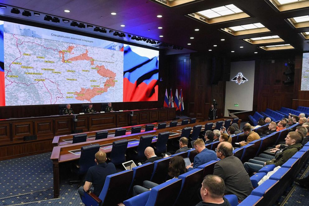
![[10]](https://commons.wikimedia.org/wiki/File_talk:2022_Russian_invasion_of_Ukraine.svg#The_latest_map_is_outdated)
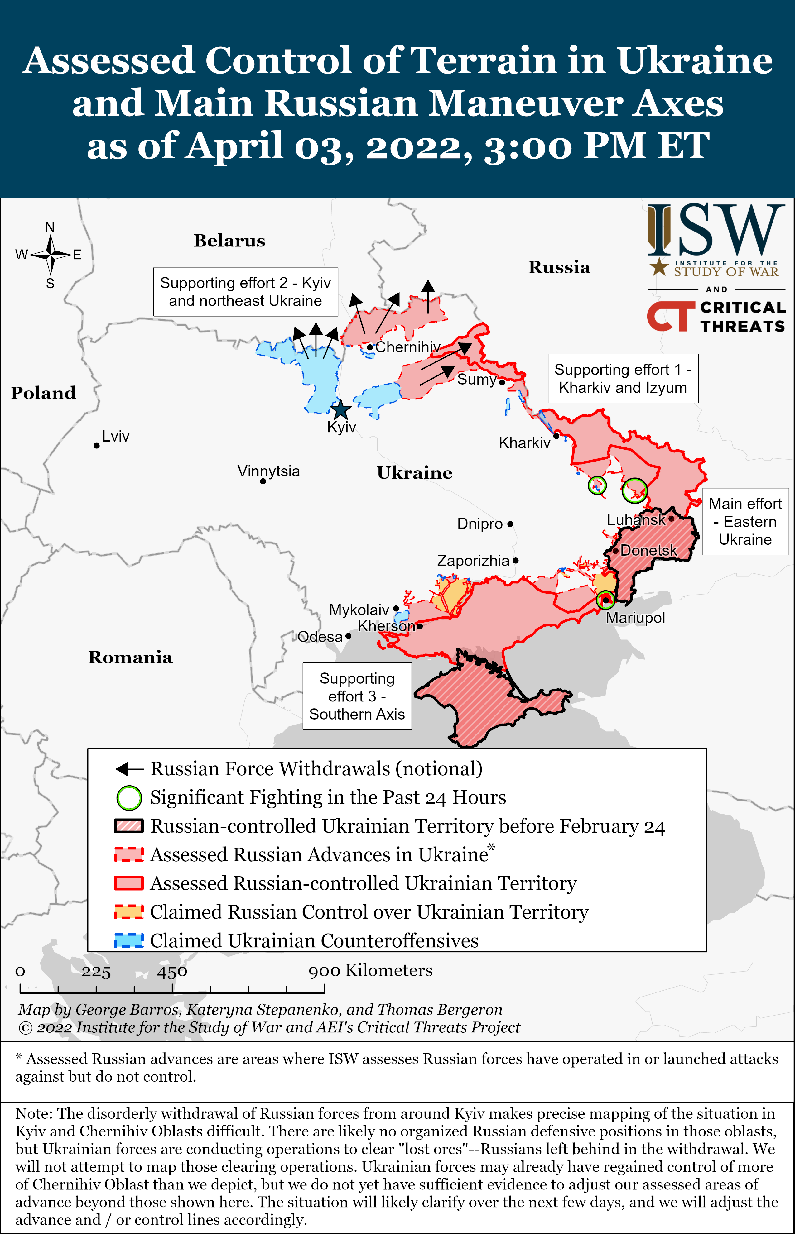
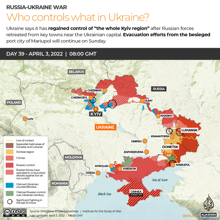
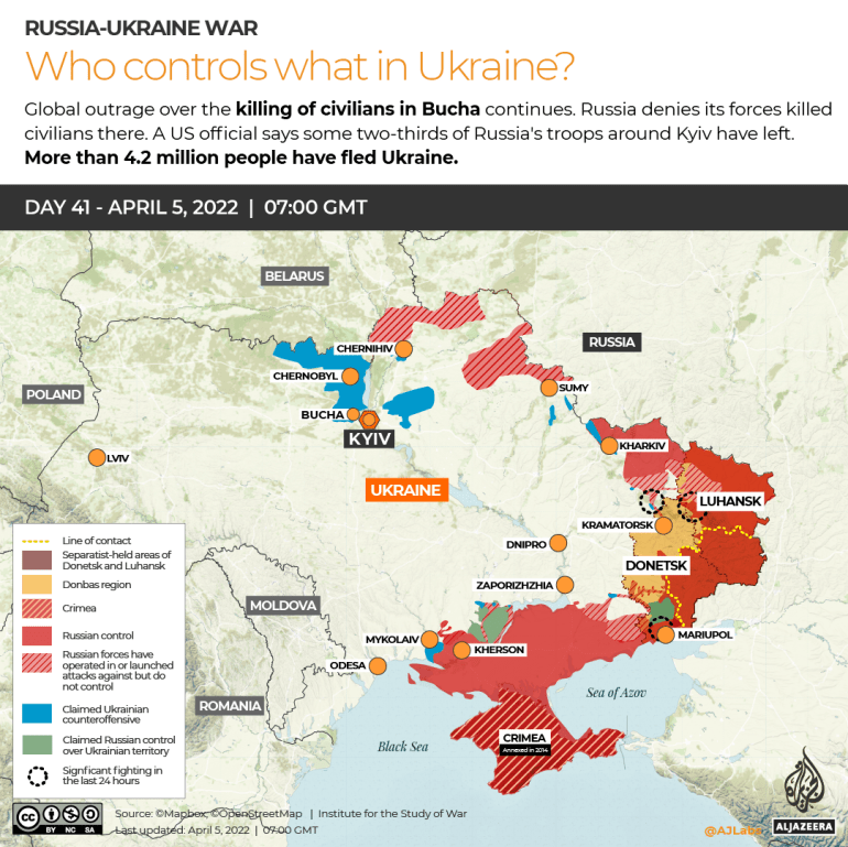
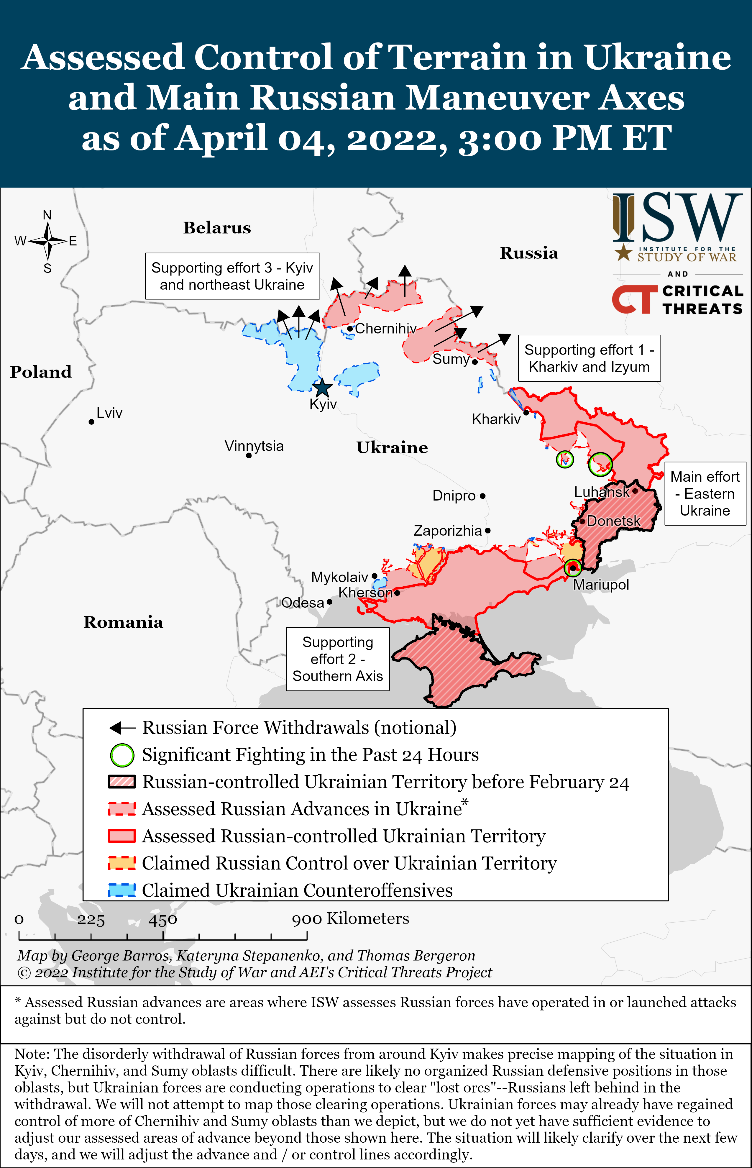
_version.)


