Category:Burgwindheim
Jump to navigation
Jump to search
municipality of Germany    | |||||
| Upload media | |||||
| Instance of |
| ||||
|---|---|---|---|---|---|
| Part of |
| ||||
| Location | Bamberg, Upper Franconia, Bavaria, Germany | ||||
| Population |
| ||||
| Area |
| ||||
| Elevation above sea level |
| ||||
| official website | |||||
 | |||||
Subcategories
This category has the following 3 subcategories, out of 3 total.
Media in category "Burgwindheim"
The following 13 files are in this category, out of 13 total.
-
 Wappen Burgwindheim.png 300 × 350; 52 KB
-
 Wappen von Burgwindheim.svg 708 × 773; 61 KB
-
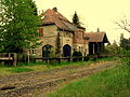 Bahnstrecke Frensdorf-Ebrach Burgwindheim2.jpg 2,592 × 1,944; 1.86 MB
-
 Burgwindheim 1.jpg 3,000 × 4,000; 3.1 MB
-
 Burgwindheim 2.jpg 4,000 × 3,000; 2.93 MB
-
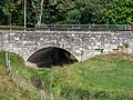 Burgwindheim Brücke Aschbacher Straße-20180909-RM-153603.jpg 5,184 × 3,888; 15.12 MB
-
 Burgwindheim im Landkreis Bamberg.png 961 × 690; 16 KB
-
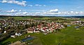 Burgwindheim Luftbild-20230423-RM-175619.jpg 5,272 × 2,850; 6.18 MB
-
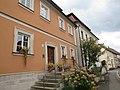
 Burgwindheim-Marktplatz.jpg 3,200 × 2,400; 2.36 MB
-
 Burgwindheim.png 336 × 242; 15 KB
-
 BurgwindheimHeiligblutbrunnen.JPG 1,488 × 1,984; 1.8 MB
-
 Heiligblutkapelle.JPG 1,476 × 1,145; 1.99 MB
-
 M-113 CAF, Fallex 82, Schweinfurt, Burgwindheim (u.a.).jpg 960 × 840; 133 KB


.jpg)