Category:Lauter (Upper Franconia)
Jump to navigation
Jump to search
municipality in the Upper Franconian district of Bamberg     | |||||
| Upload media | |||||
| Instance of |
| ||||
|---|---|---|---|---|---|
| Part of |
| ||||
| Location | Bamberg, Upper Franconia, Bavaria, Germany | ||||
| Head of government |
| ||||
| Population |
| ||||
| Area |
| ||||
| Elevation above sea level |
| ||||
| Different from | |||||
| official website | |||||
 | |||||
Subcategories
This category has the following 4 subcategories, out of 4 total.
Media in category "Lauter (Upper Franconia)"
The following 10 files are in this category, out of 10 total.
-
 DEU Lauter COA.svg 512 × 559; 161 KB
-
 Wappen von Lauter.png 686 × 750; 572 KB
-
De-Lauter.ogg 1.8 s; 17 KB
-
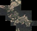 Digitales Orthofoto von Lauter (Bayerische Vermessungsverwaltung).tif 17,500 × 15,000; 455.31 MB
-
 Lauter (Upper Franconia) Luftbild-20240304-RM-163640.jpg 5,272 × 3,948; 9.35 MB
-
 Lauter (Upper Franconia) Luftbild-20240304-RM-163658.jpg 5,272 × 3,948; 10.53 MB
-
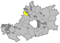 Lauter im Landkreis Bamberg.png 961 × 690; 16 KB
-
 Lauter-in-Appendorf.jpg 3,264 × 2,448; 1.85 MB
-
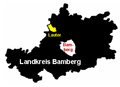 Lauter.png 344 × 250; 14 KB
-
 Wegkreuzung mit Raidelhütte am Stiefenberg nördlich von Lauter.jpg 4,000 × 3,000; 3.44 MB

_Luftbild-20240304-RM-163640.jpg)
_Luftbild-20240304-RM-163658.jpg)


