Category:Liebig Range
Jump to navigation
Jump to search
| Object location | | View all coordinates using: OpenStreetMap |
|---|
mountain range in New Zealand  | |||||
| Upload media | |||||
| Instance of | |||||
|---|---|---|---|---|---|
| Named after | |||||
| Located in protected area | |||||
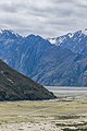
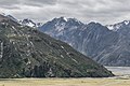
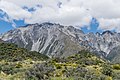
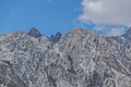
| Location | Mackenzie District, Canterbury Region, New Zealand | ||||
 | |||||
Subcategories
This category has the following 4 subcategories, out of 4 total.
Media in category "Liebig Range"
The following 13 files are in this category, out of 13 total.
-
 Landscape in Mount Cook National Park 08.jpg 3,780 × 2,520; 7.41 MB
-
 Landscape in Mount Cook National Park 09.jpg 2,440 × 3,660; 5.85 MB
-
 Landscape in Mount Cook National Park 10.jpg 3,000 × 1,109; 2.6 MB
-
 Landscape in Mount Cook National Park 11.jpg 3,000 × 2,000; 4.38 MB
-
 Landscape in Mount Cook National Park 31.jpg 4,057 × 2,705; 8.55 MB
-
 Landscape in Mount Cook National Park 32.jpg 3,871 × 2,581; 7.78 MB
-
 Liebig Range 01.jpg 3,984 × 2,656; 7.24 MB
-
 Liebig Range 02.jpg 3,603 × 2,272; 6.12 MB
-
 Tasman Lake 06.jpg 4,034 × 2,689; 7.68 MB
-
 Valley of Hooker River 01.jpg 2,818 × 1,586; 3.26 MB
-
 Valley of Hooker River 02.jpg 3,796 × 2,085; 5.54 MB
-
 View of Liebig Range from Blue Lakes 01.jpg 3,914 × 2,609; 8.46 MB
-
 View of Liebig Range from Blue Lakes 02.jpg 3,904 × 2,603; 8.52 MB


