Category:Old maps of Ireland
Jump to navigation
Jump to search
Countries of Europe: Albania · Andorra · Armenia‡ · Austria · Azerbaijan‡ · Belarus · Belgium · Bosnia and Herzegovina · Bulgaria · Croatia · Cyprus‡ · Czech Republic · Denmark · Estonia · Finland · France‡ · Georgia‡ · Germany · Greece · Hungary · Iceland · Republic of Ireland · Italy · Kazakhstan‡ · Latvia · Lithuania · Luxembourg · Malta · Moldova · Monaco · Montenegro · Netherlands‡ · Norway · Poland · Portugal‡ · Romania · Russia‡ · Serbia · Slovakia · Slovenia · Spain‡ · Sweden · Switzerland · Turkey‡ · Ukraine · United Kingdom · Vatican City
Specific status: Faroe Islands · Gibraltar · Bailiwick of Guernsey · Isle of Man · Jersey · Svalbard – Limited recognition: Kosovo · Transnistria
‡: partly located in Europe
Specific status: Faroe Islands · Gibraltar · Bailiwick of Guernsey · Isle of Man · Jersey · Svalbard – Limited recognition: Kosovo · Transnistria
‡: partly located in Europe
This category is for old maps showing all or a large part of Ireland.
Use the appropriate category for maps showing all or a large part of Republic of Ireland. See subcategories for smaller areas:
| If the map shows | Category to use |
|---|---|
| Republic of Ireland on a recently created map | Category:Maps of Ireland or its subcategories |
| Republic of Ireland on a map created more than 70 years ago | Category:Old maps of Ireland or its subcategories |
| the history of Republic of Ireland on a recently created map | Category:Maps of the history of Ireland or its subcategories |
| the history of Republic of Ireland on a map created more than 70 years ago | Category:Old maps of the history of Ireland or its subcategories |
Subcategories
This category has the following 23 subcategories, out of 23 total.
Media in category "Old maps of Ireland"
The following 133 files are in this category, out of 133 total.
-
 (Map of Ulster County, Ireland). LOC 2005625224.jpg 16,799 × 10,738; 18.93 MB
-
 (Map of Ulster County, Ireland). LOC 2005625224.tif 16,799 × 10,738; 516.09 MB
-

-

-
 125 of 'Young Ireland ... Final revision. Illustrated' (11235042746).jpg 1,476 × 2,280; 705 KB
-

-
 16th Century Map of Cork - Extracted and replicated from Pacata Hibernia page 137.png 2,296 × 1,290; 6.03 MB
-

-
 17th Century Barony Maps c.1609 - Tyrone etc. (27484911573).jpg 2,048 × 1,707; 2.63 MB
-
 183 of 'Ireland- its Scenery, Character, etc' (11018867256).jpg 2,736 × 1,776; 657 KB
-
 1832 Irish Postal Circulation Map.jpg 1,497 × 1,966; 710 KB
-
 Map of ERRIS and GALWAY.jpg 3,692 × 4,593; 9.47 MB
-
 GRIBAYÈDOFF(1890) p141 Map of Connaught.jpg 1,713 × 1,213; 916 KB
-
 Carlow-Map.jpg 2,230 × 2,961; 2.23 MB
-

-

-

-

-

-
 237 of 'Ireland- its Scenery, Character, etc' (11018953055).jpg 1,652 × 2,570; 948 KB
-
 26 of 'Rigby's Illustrated Guide to Belfast and the North of Ireland' (11231581965).jpg 4,858 × 2,036; 2.09 MB
-
 268 of 'Ireland- its Scenery, Character, etc' (11018609305).jpg 2,736 × 1,878; 1.01 MB
-
 271 of 'Die Erde. Eine allgemeine Erd- und Länderkunde, etc' (11301256304).jpg 1,007 × 1,090; 328 KB
-
 38 of '(A Week at Killarney.)' (11055740456).jpg 1,678 × 2,504; 1.14 MB
-

-

-
 446 of '(Our own country. Descriptive, historical, pictorial.)' (11210807306).jpg 1,889 × 1,508; 752 KB
-
 450 of 'Ireland- its Scenery, Character, etc' (11018820714).jpg 2,672 × 1,833; 1.05 MB
-

-
-

-

-

-

-

-

-

-

-

-

-
 91 of 'Cusack's Reign of Queen Elizabeth for scholarship candidates' (11230815374).jpg 1,182 × 1,786; 544 KB
-

-

-
 A chart of the BAY OF GALLOWAY and RIVER SHANNON NYPL1640581.tiff 7,230 × 5,428; 112.28 MB
-
 A Chart of the Coasts of Ireland and Part of England - btv1b530567584.jpg 6,968 × 6,016; 5.09 MB
-
 A chart of the NORTH-WEST coast of IRELAND from LOUGH SWILLY to SLYNE HEAD NYPL1640580.tiff 7,230 × 5,428; 112.28 MB
-
-
 A description of a chart Fleuron T071221-2.png 1,321 × 1,556; 65 KB
-
 A map of Ireland Wellcome V0049913.jpg 3,313 × 2,475; 4.08 MB
-

-
 A Modern Depiction of Ireland, One of the British Isles WDL104.png 1,315 × 1,024; 2.91 MB
-

-
 Admiralty Chart Catalogue 1967 Page 015 Index B.jpg 8,586 × 6,835; 9.79 MB
-
 Admiralty Chart No 1824b West Coast of Ireland, Published 1959.jpg 11,379 × 20,410; 46.68 MB
-
 Aitkin's Rock.jpg 7,435 × 3,199; 1.57 MB
-

-

-
-

-
 Atlantic islands-Konkani Vishwakosh.png 539 × 606; 75 KB
-
 Atlas Van der Hagen-KW1049B11 049-PROVINCIA VLITONIA The PROVINCIE of ULSTER.jpeg 5,500 × 4,313; 3.88 MB
-
 Atlas Van der Hagen-KW1049B11 050-PROVINCIA COMMACHITIAE The PROVINCE of CONNAVGT..jpeg 5,500 × 4,335; 3.27 MB
-
 Atlas Van der Hagen-KW1049B11 051-COMITATVS LAGENIAE The COVNTIE of LEINSTER.jpeg 5,500 × 4,358; 3.64 MB
-
 Atlas Van der Hagen-KW1049B11 053-PROVINCIA MOMONIA The PROVINCE of MOVNSTER.jpeg 5,500 × 4,348; 3.84 MB
-
 Baronies of Ireland 1846.jpg 1,200 × 1,952; 452 KB
-
 Barony of Carbery.png 661 × 354; 21 KB
-
 Bodleian Libraries, Map of Ireland.jpg 1,000 × 675; 144 KB
-
 Breifne700AD.png 1,110 × 710; 396 KB
-
 Cartografie in Nederland, kaart van Ierland, NG-501-38.jpg 4,852 × 5,602; 5.24 MB
-

-
 Clew bay-old map.jpg 882 × 502; 208 KB
-
 D352- N° 487. Côtes à ports nombreux. - Liv4-Ch02.png 1,445 × 1,932; 171 KB
-
 D503 - N° 294. Irlande, l’Ile d’Emeraude. -liv3-ch5.png 1,444 × 1,828; 420 KB
-
 DeCusack Map.jpg 300 × 263; 67 KB
-

-
 Dungannon Castle and the stone chair at Tullyhogue, Co. Tyrone.png 1,207 × 2,000; 4.85 MB
-
 Hybernia Nunc Irlant - btv1b530569884.jpg 3,168 × 4,328; 2.66 MB
-
 Hybernia nunc Irlant - btv1b55000021z.jpg 4,452 × 6,179; 2.8 MB
-
 Hybernia nunc Irlant - btv1b55004831s.jpg 3,541 × 4,573; 2.09 MB
-
 Hybernia nunc Irlant - btv1b550049940.jpg 3,355 × 4,415; 1.85 MB
-
 Hybernia nunc Irlant - btv1b8490414z.jpg 4,144 × 5,512; 4.68 MB
-
 Image taken from page 259 of 'Aus Irland. Reiseskizzen und Studien' (11117034654).jpg 5,248 × 4,538; 5.38 MB
-
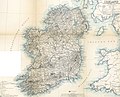 Image taken from page 259 of 'Aus Irland. Reiseskizzen und Studien' (15970470183).jpg 4,656 × 3,759; 2.89 MB
-

-
 Ireland's ancient schools and scholars (1903) (14756226886).jpg 3,504 × 2,130; 757 KB
-
 Ireland, The Emerald Isle (4769193206).jpg 2,170 × 3,197; 1,001 KB
-
 Irish Chart (28133683222).jpg 2,000 × 1,575; 2.63 MB
-
 Irish Emigration and The Tenure of Land in Ireland 146.png 2,026 × 3,488; 2.8 MB
-
 Irlanda sett..jpg 640 × 474; 216 KB
-
 John Speed, map of Ireland.jpg 3,456 × 2,592; 5.92 MB
-
 Kerry cropped 1690.jpeg 1,249 × 1,201; 518 KB
-
 Kilcullen and K-Bridge, Taylor and Skinner, 18C roadmap.jpg 392 × 592; 128 KB
-

-
 L'Irlande - Par J. D. Barbié du Bocage ; Doudan sculpsit ; Dien scripsit - btv1b84954400.jpg 5,920 × 7,083; 6.37 MB
-
 L'Irlande - Par J.D.Barbié du Bocage - btv1b8494900w.jpg 5,454 × 7,099; 5.57 MB
-
 Lewis's Atlas comprising the counties of Ireland, and a general map of the kingdom (IA lewisatlas).pdf 1,785 × 2,358, 82 pages; 9.35 MB
-

-
-
 MappaBritanniaeFacie.jpg 2,954 × 2,557; 837 KB
-
 MappaBritanniaeFacie2.png 1,500 × 1,312; 4.43 MB
-

-

-

-

-

-

-

-

-

-

-
 Provincia Connachtiae = The province of Connaugt - CBT 6595916.jpg 5,704 × 4,416; 6.81 MB
-
 Provincia Momoniae = The province of Mounster - CBT 6595959.jpg 5,612 × 4,427; 6.9 MB
-

-

-

-

-

-
 Richard bartlett tullahogue inauguration chair 1602.png 351 × 581; 546 KB
-
 Skelling Michael ft1d5nb0gb 00009.gif 620 × 539; 30 KB
-
 Southwest Ireland Thornton.jpg 2,873 × 2,448; 4.32 MB
-

-
 The Halfe Baronies of Lvrgh and Cole Mackernan (28099990235).jpg 2,048 × 1,574; 1.94 MB
-
 The parish of Kilflynn and environs 1656-1658.jpg 1,280 × 658; 142 KB
-
 The Province of Mounster RMG E9078.tiff 3,800 × 3,037; 33.02 MB
-
 The SOUTH-WEST coast of IRELAND from Dungarvan to the River Shannon NYPL1640582.tiff 7,230 × 5,428; 112.28 MB
-
 Tullyhunco 1609 Map.jpg 3,045 × 2,352; 3.07 MB
-
 Tyrconnelle etc (28099674095).jpg 2,048 × 1,733; 2.13 MB
-
 UBBasel Map 1570-1590 Kartenslg Mappe 238-57b.tif 4,244 × 4,093, 2 pages; 49.72 MB
-
 UBBasel Map Irland 1677-1702 Kartenslg Mappe 238-56.tif 8,115 × 10,464, 2 pages; 242.97 MB
-
 Wenceslas Hollar - Ireland (State 2).jpg 2,211 × 3,119; 2.03 MB
-
 Wenceslas Hollar - St Patrick's Isle (State 2).jpg 2,547 × 3,532; 3.03 MB
-
 Geographischer Atlas bestehend in 44 Land-Charten 1760 (131788493).jpg 7,325 × 10,110; 71.75 MB
-

._LOC_2005625224.jpg)
.jpg)
.jpg)
.jpg)
.jpg)

.jpg)
.jpg)
.jpg)


_p141_Map_of_Connaught.jpg)

_..._In_two_volumes.)%27_(11002757105).jpg)
.jpg)
.jpg)
.jpg)
.jpg)
.jpg)
.jpg)
.jpg)
.jpg)
%27_(11055740456).jpg)
.jpg)
.jpg)
%27_(11210807306).jpg)
.jpg)
%27_(11006472743).jpg)
.jpg)
%27_(11202397345).jpg)
%27_(11161008066).jpg)
%27_(11164709964).jpg)
.jpg)
%27_(11109018505).jpg)
.jpg)
.jpg)
.jpg)
%27_(10998743495).jpg)
.jpg)
.jpg)
.jpg)
.jpg)


.jpg)
.jpg)
.jpg)
.jpg)


.jpg)
.jpg)
%27_(11171924845).jpg)
_(14756226886).jpg)
.jpg)
.jpg)


.jpg)
.jpg)
.jpg)
.jpg)
.jpg)
.jpg)
.jpg)


.jpg)


.jpg)
.jpg)
.jpg)
.jpg)
.jpg)