File:中國南海各島嶼圖.jpg
Fichier d’origine (2 568 × 3 589 pixels, taille du fichier : 4,39 Mio, type MIME : image/jpeg)
Légendes
Légendes
Description
[modifier]
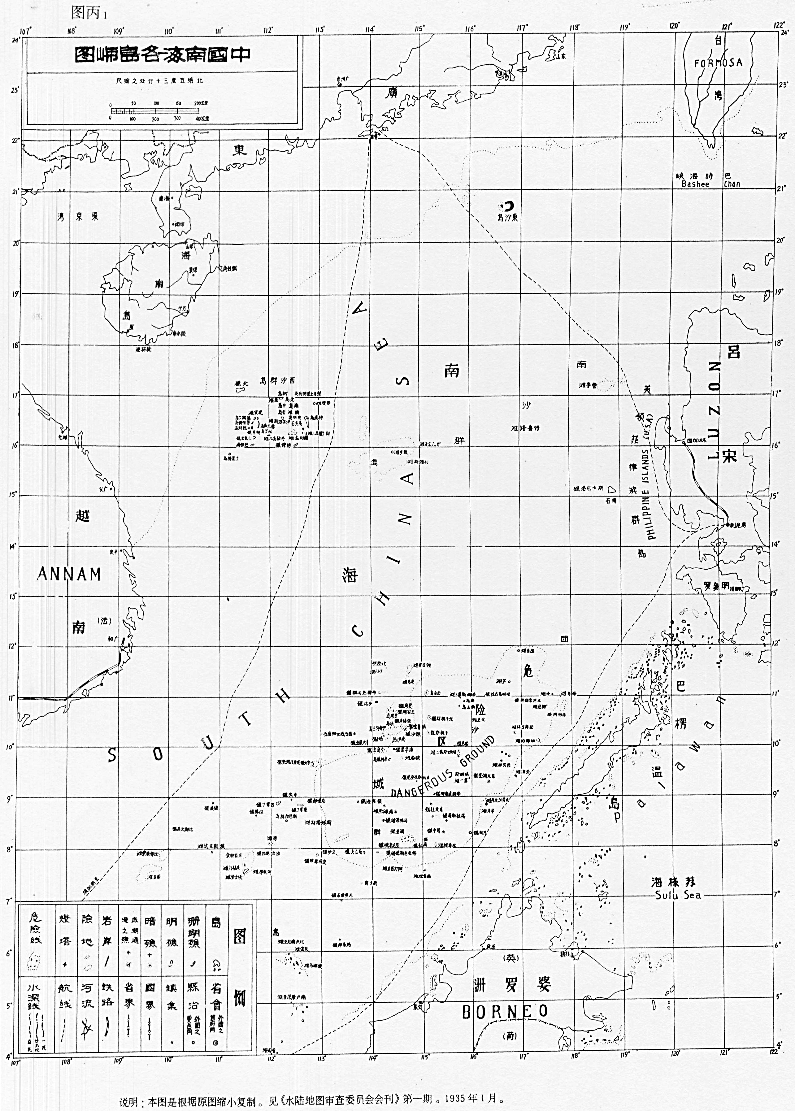
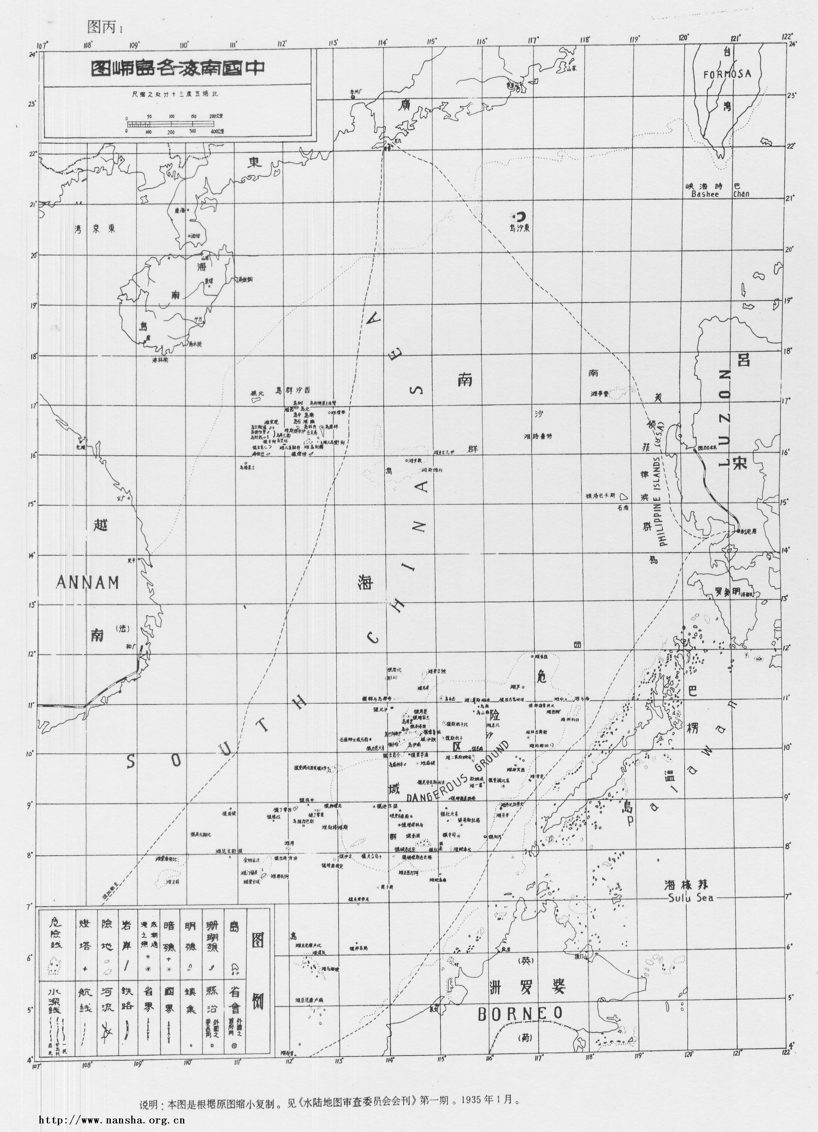
| Description | carte des îles chinoises dans la mer de Chine méridionale (Zhongguo nanhai ge daoyu tu - 中國南海各島嶼圖) |
| Date | |
| Source | http://www.spratlys.org/maps/4/1935_South_China_Sea_Islands_Map.jpg |
| Auteur | 水陸地圖審查委員會 (comité de cartographie terrestre et maritime de la République de Chine) |
Conditions d’utilisation
[modifier]
This image is now in the public domain in China because its term of copyright has expired. According to copyright laws of the People's Republic of China (with legal jurisdiction in the mainland only, excluding Hong Kong and Macao), amended November 11, 2020, Works of legal persons or organizations without legal personality, or service works, or audiovisual works, enter the public domain 50 years after they were first published, or if unpublished 50 years from creation. For photography works of natural persons whose copyright protection period expires before June 1, 2021 belong to the public domain. All other works of natural persons enter the public domain 50 years after the death of the creator. To uploader: Please provide where the image was first published and who created it or held its copyright.
|
  |
Cette œuvre est dans le domaine public car elle a été publiée aux États-Unis entre 1929 et 1977 inclus, sans indication de copyright. À moins que son auteur ne soit mort depuis suffisamment longtemps, elle n'est pas dans le domaine public dans les pays ou régions qui n'appliquent pas la règle du terme le plus court pour les travaux provenant des États-Unis, comme le Canada (cinquante ans pma), la Chine continentale (cinquante ans pma, Hong Kong et Macao exclus), l'Allemagne (soixante-dix ans pma), le Mexique (cent ans pma), la Suisse (soixante-dix ans pma) et d'autres pays signataires d'accord bilatéraux. Voir cette page pour de plus amples explications.
|
 |
Historique du fichier
Cliquer sur une date et heure pour voir le fichier tel qu'il était à ce moment-là.
| Date et heure | Vignette | Dimensions | Utilisateur | Commentaire | |
|---|---|---|---|---|---|
| actuel | 5 octobre 2016 à 16:56 | | 2 568 × 3 589 (4,39 Mio) | Micheletb (d | contributions) | {{Information |Description=carte des îles chinoises dans la mer de Chine méridionale (Zhongguo nanhai ge daoyu tu - 中國南海各島嶼圖) |Source=http://www.spratlys.org/maps/4/1935_South_China_Sea_Islands_Map.jpg |Date=1935 |Author=水陸地圖... |
Vous ne pouvez pas remplacer ce fichier.
Utilisations locales du fichier
Aucune page n’utilise ce fichier.
Utilisations du fichier sur d’autres wikis
Les autres wikis suivants utilisent ce fichier :
- Utilisation sur fr.wikipedia.org