File:1837 Malte-Brun Map of China and Japan - Geographicus - China-mb-1837.jpg
Salta a la navegació
Salta a la cerca

Mida d'aquesta previsualització: 794 × 600 píxels. Altres resolucions: 318 × 240 píxels | 636 × 480 píxels | 1.017 × 768 píxels | 1.280 × 967 píxels | 2.328 × 1.758 píxels.
Fitxer original (2.328 × 1.758 píxels, mida del fitxer: 772 Ko, tipus MIME: image/jpeg)
Llegendes
Llegendes
Afegeix una explicació d'una línia del que representa aquest fitxer
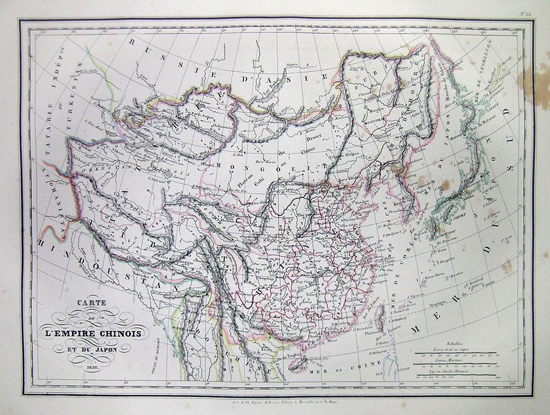
| Carte de L’Empire Chinois de Du Japon 1836. | ||||||
|---|---|---|---|---|---|---|
| Artista | ||||||
| Títol |
Carte de L’Empire Chinois de Du Japon 1836. |
|||||
| Descripció |
English: This is a beautiful 1836 Hand colored map of China and Japan. Includes Tartary and the Mongol Empire. All text is in French. |
|||||
| Data | 1837 | |||||
| Dimensions | altura: 9 in (22,8 cm); amplada: 12 in (30,4 cm) | |||||
| Número d'inventari |
Geographicus link: China-mb-1837 |
|||||
| Origen/Fotògraf |
|
|||||
| Permís (Com reutilitzar aquest fitxer) |
|
|||||
| Altres versions | ||||||
_in_1837_from_Malte-Brun_Map_of_China_and_Japan_(cropped).jpg)
| Anotacions | Aquesta imatge té anotacions: Vegeu-les a Commons |
Historial del fitxer
Cliqueu una data/hora per veure el fitxer tal com era aleshores.
| Data/hora | Miniatura | Dimensions | Usuari/a | Comentari | |
|---|---|---|---|---|---|
| actual | 11:39, 16 març 2011 | | 2.328 × 1.758 (772 Ko) | BotMultichill (discussió | contribucions) | {{subst:User:Multichill/Geographicus |link=http://www.geographicus.com/P/AntiqueMap/China-mb-1837 |product_name=1837 Malte-Brun Map of China and Japan |map_title=Carte de L’Empire Chinois de Du Japon 1836. |description=This is a beautiful 1836 Hand co |
No podeu sobreescriure aquest fitxer.
Ús del fitxer
Les 2 pàgines següents utilitzen aquest fitxer:
Ús global del fitxer
Utilització d'aquest fitxer en altres wikis:
- Utilització a ca.wikipedia.org
- Utilització a en.wikipedia.org
- Utilització a fr.wikipedia.org
Categories:
- 1830s maps of China
- 19th-century maps of Korea
- 1830s maps of Japan
- Old maps of the Sea of Japan
- 1836 maps
- Victor Adolphe Malte-Brun
- 19th-century maps of Vietnam
- 19th-century maps of Tibet
- 19th-century maps of Mongolia
- Maps of East Turkestan
- Old maps of Taiwan
- 1836 in Tibet
- Qinghai Lake
- Maps of Kham
- Ü-Tsang
- Maps of Amdo