File:1855 Colton Map of Turkey, Iraq, and Syria - Geographicus - TurkeyIraq-colton-1855.jpg
跳转到导航
跳转到搜索
本预览的尺寸:692 × 600像素。 其他分辨率:277 × 240像素 | 554 × 480像素 | 886 × 768像素 | 1,181 × 1,024像素 | 2,363 × 2,048像素 | 3,500 × 3,034像素。
原始文件 (3,500 × 3,034像素,文件大小:3.22 MB,MIME类型:image/jpeg)
说明
说明
添加一行文字以描述该文件所表现的内容
| J. H. Colton:Turkey in Asia and the Caucasian Provinces of Russia
( |
|||||||||||||||||||||
|---|---|---|---|---|---|---|---|---|---|---|---|---|---|---|---|---|---|---|---|---|---|
| 艺术家 |
|
||||||||||||||||||||
| 标题 |
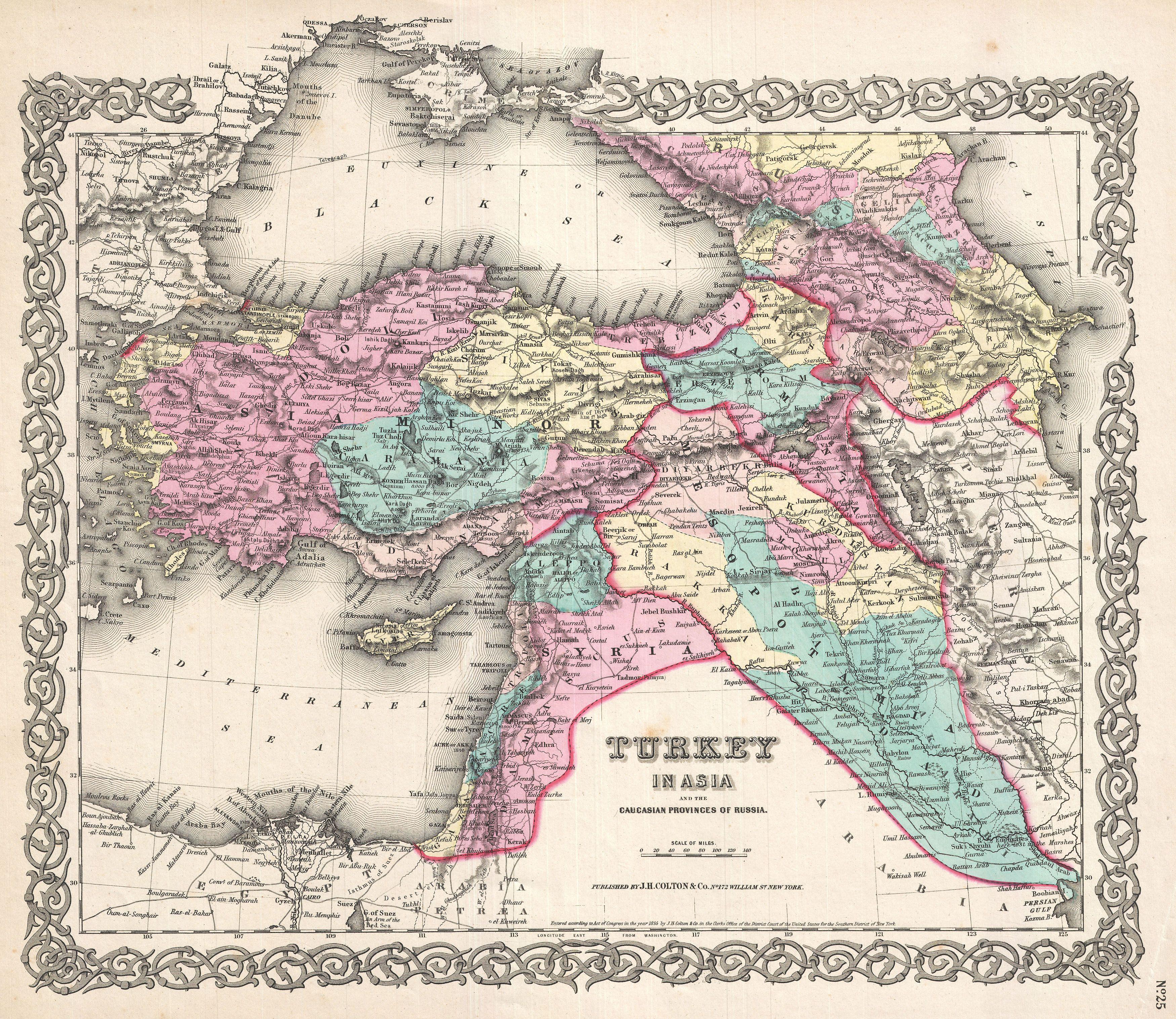
Turkey in Asia and the Caucasian Provinces of Russia |
||||||||||||||||||||
| 描述 |
العربية: خريطة جميلة لِإيالات الدولة العُثمانيَّة في آسيا وتظهر فيها المُقاطعات القوقازيَّة التي تُسيطر عليها روسيا. تعود هذه الخريطة لِلطبعة الأولى لِأطلس كولتون الصادر سنة 1855م.
English: A beautiful 1855 first edition example of Colton's map of the Ottoman Empire (Turkey) in Asia and the Caucuses.
|
||||||||||||||||||||
| 日期 | 1855年 (dated) | ||||||||||||||||||||
| 尺寸 | 高度:13英寸(33厘米);宽度:16.5英寸(41.9厘米) | ||||||||||||||||||||
| 登录号 |
Geographicus link: TurkeyIraq-colton-1855 |
||||||||||||||||||||
| 来源/摄影师 |
Colton, G. W., Colton's Atlas of the World Illustrating Physical and Political Geography, Vol 2, New York, 1855 (First Edition).
|
||||||||||||||||||||
| 授权 (二次使用本文件) |
|
||||||||||||||||||||
| 其他版本 | 此文件衍生的作品: Ottoman vilayet of Kurdistan.jpg | ||||||||||||||||||||

|
文件历史
点击某个日期/时间查看对应时刻的文件。
| 日期/时间 | 缩略图 | 大小 | 用户 | 备注 | |
|---|---|---|---|---|---|
| 当前 | 2011年3月23日 (三) 15:33 | | 3,500 × 3,034(3.22 MB) | BotMultichillT(留言 | 贡献) | {{subst:User:Multichill/Geographicus |link=http://www.geographicus.com/P/AntiqueMap/TurkeyIraq-colton-1855 |product_name=1855 Colton Map of Turkey, Iraq, and Syria |map_title=Turkey in Asia and the Caucasian Provinces of Russia. |description=A beautiful 1 |
您不可以覆盖此文件。
文件用途
以下2个页面使用本文件:
全域文件用途
以下其他wiki使用此文件:
- ar.wikipedia.org上的用途
- الأقاليم السورية الشمالية
- إيالة عثمانية
- العراق العثماني
- بوابة:الدولة العثمانية/صورة
- مستخدم:عمرو بن كلثوم/الأقاليم السورية الشمالية
- ويكيبيديا:صور مختارة/رسومات وجداول وخرائط/خرائط
- قائمة إيالات الدولة العثمانية
- ويكيبيديا:ترشيحات الصور المختارة/الإيالات العثمانية الآسيوية
- ويكيبيديا:صورة اليوم المختارة/أغسطس 2017
- قالب:صورة اليوم المختارة/2017-08-11
- بوابة:الدولة العثمانية/صورة مختارة/35
- ويكيبيديا:صورة اليوم المختارة/يناير 2020
- قالب:صورة اليوم المختارة/2020-01-14
- الحدود الإيرانية التركية
- ويكيبيديا:صورة اليوم المختارة/نوفمبر 2022
- قالب:صورة اليوم المختارة/2022-11-16
- arz.wikipedia.org上的用途
- az.wikipedia.org上的用途
- bn.wikipedia.org上的用途
- ckb.wikipedia.org上的用途
- en.wikipedia.org上的用途
- et.wikipedia.org上的用途
- fa.wikipedia.org上的用途
- it.wikipedia.org上的用途
- ko.wikipedia.org上的用途
- ku.wikipedia.org上的用途
- pnb.wikipedia.org上的用途
- ro.wikipedia.org上的用途
- tr.wikipedia.org上的用途
- ur.wikipedia.org上的用途
- www.wikidata.org上的用途
- zh.wikipedia.org上的用途