File:A map of Virginia - formed from actual surveys, and the latest as well as most accurate observations (NYPL b15063213-1949371).tiff

Original file (5,267 × 5,248 pixels, file size: 79.09 MB, MIME type: image/tiff)
Captions
Captions
Summary
[edit]| Description |
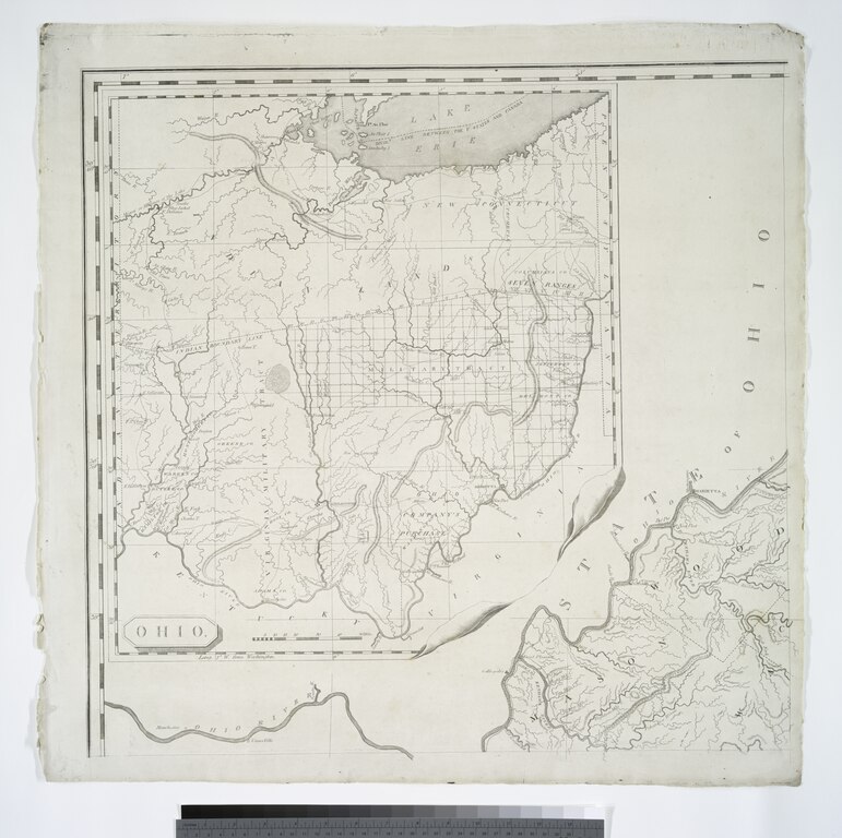
English: * Insets: [View of] The city of Richmond, metropolis of Virginia -- Ohio. |
||
| Title | A map of Virginia : formed from actual surveys, and the latest as well as most accurate observations | ||
| Date | |||
| Source | https://digitalcollections.nypl.org/items/8af7cd16-c677-f3a6-e040-e00a1806403a | ||
| Author | Scan by NYPL | ||
| Permission (Reusing this file) |
|
||
| Other versions |
|
||
| UUID | f1699ca0-c5d4-012f-6710-58d385a7bc34 | ||
| MODS | http://api.repo.nypl.org/api/v1/items/mods/8af7cd16-c677-f3a6-e040-e00a1806403a | ||
| Origin place | By the Proprietors | ||
| Image ID | 1949371 | ||
| Collection | Lawrence H. Slaughter Collection of English maps, charts, globes, books and atlases | ||
| Collection UUID | 8af7cd16-c677-f3a6-e040-e00a1806403a | ||
| NYPL catalog ID | b15063213 |
.jpg)
.jpg)
.jpg)

.jpg)


.jpg)
Licensing
[edit]This image is in the public domain because it is a mere mechanical scan or photocopy of a public domain original, or – from the available evidence – is so similar to such a scan or photocopy that no copyright protection can be expected to arise. The original itself is in the public domain for the following reason:
This tag is designed for use where there may be a need to assert that any enhancements (eg brightness, contrast, colour-matching, sharpening) are in themselves insufficiently creative to generate a new copyright. It can be used where it is unknown whether any enhancements have been made, as well as when the enhancements are clear but insufficient. For known raw unenhanced scans you can use an appropriate {{PD-old}} tag instead. For usage, see Commons:When to use the PD-scan tag.  | ||||
File history
Click on a date/time to view the file as it appeared at that time.
| Date/Time | Thumbnail | Dimensions | User | Comment | |
|---|---|---|---|---|---|
| current | 06:02, 14 April 2020 |  | 5,267 × 5,248 (79.09 MB) | SteinsplitterBot (talk | contribs) | Bot: Image rotated by 270° |
| 16:11, 1 July 2016 |  | 5,248 × 5,267 (79.09 MB) | Fæ (talk | contribs) | Lawrence Slaughter http://digitalcollections.nypl.org/items/8af7cd16-c677-f3a6-e040-e00a1806403a, part of User:Fæ/Project list/NYPL T716.752 |
You cannot overwrite this file.
File usage on Commons
The following 11 pages use this file:
- File:A map of Virginia - formed from actual surveys, and the latest as well as most accurate observations (NYPL b15063213-1949371).jpg
- File:A map of Virginia - formed from actual surveys, and the latest as well as most accurate observations (NYPL b15063213-1949372).jpg
- File:A map of Virginia - formed from actual surveys, and the latest as well as most accurate observations (NYPL b15063213-1949372).tiff
- File:A map of Virginia - formed from actual surveys, and the latest as well as most accurate observations (NYPL b15063213-1949373).jpg
- File:A map of Virginia - formed from actual surveys, and the latest as well as most accurate observations (NYPL b15063213-1949373).tiff
- File:A map of Virginia - formed from actual surveys, and the latest as well as most accurate observations (NYPL b15063213-1949374).jpg
- File:A map of Virginia - formed from actual surveys, and the latest as well as most accurate observations (NYPL b15063213-1949374).tiff
- File:A map of Virginia - formed from actual surveys, and the latest as well as most accurate observations (NYPL b15063213-1949375).jpg
- File:A map of Virginia - formed from actual surveys, and the latest as well as most accurate observations (NYPL b15063213-1949376).jpg
- File:A map of Virginia - formed from actual surveys, and the latest as well as most accurate observations (NYPL b15063213-1949376).tiff
- File:A map of Virginia - formed from actual surveys, and the latest as well as most accurate observations (NYPL b15063213-484839).jpg
.jpg)
.jpg)