File:China Xinjiang location map.svg
跳至導覽
跳至搜尋

此 SVG 檔案的 PNG 預覽的大小:686 × 599 像素。 其他解析度:275 × 240 像素 | 550 × 480 像素 | 879 × 768 像素 | 1,172 × 1,024 像素 | 2,345 × 2,048 像素 | 2,220 × 1,939 像素。
原始檔案 (SVG 檔案,表面大小:2,220 × 1,939 像素,檔案大小:464 KB)
說明
說明
添加單行說明來描述出檔案所代表的內容
摘要
[編輯]| 描述 |
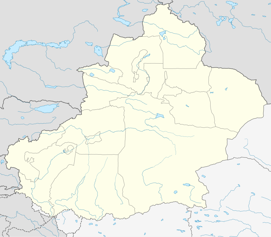
Deutsch: Positionskarte von Xinjiang, Volksrepublik China im Jahr 2010
Quadratische Plattkarte, N-S-Streckung 135 %. Geographische Begrenzung der Karte:
English: Location map of Xinjiang, People's Republic of China, in 2010
Equirectangular projection, N/S stretching 135 %. Geographic limits of the map:
|
|
| 日期 | ||
| 來源 |
自己的作品, using
|
|
| 作者 | NordNordWest | |
| 授權許可 (重用此檔案) |
此檔案採用創用CC 姓名標示-相同方式分享 3.0 德國授權條款。
 此檔案採用創用CC 姓名標示-相同方式分享 3.0 德國授權條款。
|
|
| 其他版本 |
|
|
| SVG開發 |


檔案歷史
點選日期/時間以檢視該時間的檔案版本。
| 日期/時間 | 縮圖 | 尺寸 | 使用者 | 備註 | |
|---|---|---|---|---|---|
| 目前 | 2020年6月10日 (三) 07:23 | | 2,220 × 1,939(464 KB) | NordNordWest(留言 | 貢獻) | corr |
| 2020年6月9日 (二) 22:16 |  | 2,220 × 1,939(470 KB) | Bjh21(留言 | 貢獻) | Reverted to version as of 13:31, 9 June 2020 (UTC): COM:UPLOADWAR; at least two users are of the opinion that this change is not minor, and I'm coming close to that view myself | |
| 2020年6月9日 (二) 22:09 |  | 2,220 × 1,939(820 KB) | Geographyinitiative(留言 | 貢獻) | Reverted to version as of 01:15, 9 June 2020 (UTC) Incorrect map is incorrect | |
| 2020年6月9日 (二) 13:31 |  | 2,220 × 1,939(470 KB) | NordNordWest(留言 | 貢獻) | Reverted to version as of 15:35, 28 December 2012 (UTC) again: only vector data in this svg please | |
| 2020年6月9日 (二) 01:15 |  | 2,220 × 1,939(820 KB) | Geographyinitiative(留言 | 貢獻) | Reverted to version as of 05:18, 13 April 2020 (UTC) | |
| 2020年5月24日 (日) 20:48 |  | 2,220 × 1,939(470 KB) | Roy17(留言 | 貢獻) | Reverted to version as of 15:35, 28 December 2012 (UTC) | |
| 2020年4月13日 (一) 05:18 |  | 2,220 × 1,939(820 KB) | Geographyinitiative(留言 | 貢獻) | Reverted to version as of 06:36, 29 January 2019 (UTC) See talk page | |
| 2019年1月29日 (二) 10:41 |  | 2,220 × 1,939(470 KB) | NordNordWest(留言 | 貢獻) | Reverted to version as of 15:35, 28 December 2012 (UTC); only vector data in this svg please | |
| 2019年1月29日 (二) 06:36 |  | 2,220 × 1,939(820 KB) | 复旦大学张超(留言 | 貢獻) | edit | |
| 2012年12月28日 (五) 15:35 |  | 2,220 × 1,939(470 KB) | NordNordWest(留言 | 貢獻) | upd |
無法覆蓋此檔案。
檔案用途
下列3個頁面有用到此檔案:
全域檔案使用狀況
以下其他 wiki 使用了這個檔案:
- ar.wikipedia.org 的使用狀況
- ba.wikipedia.org 的使用狀況
- bg.wikipedia.org 的使用狀況
- ceb.wikipedia.org 的使用狀況
- ce.wikipedia.org 的使用狀況
- ckb.wikipedia.org 的使用狀況
- cs.wikipedia.org 的使用狀況
- en.wikipedia.org 的使用狀況
- eo.wikipedia.org 的使用狀況
- es.wikipedia.org 的使用狀況
- et.wikipedia.org 的使用狀況
- fa.wikipedia.org 的使用狀況
- incubator.wikimedia.org 的使用狀況
- kbd.wikipedia.org 的使用狀況
- kn.wikipedia.org 的使用狀況
- ko.wikipedia.org 的使用狀況
- mk.wikipedia.org 的使用狀況
- or.wikipedia.org 的使用狀況
- pl.wikibooks.org 的使用狀況
- pnb.wikipedia.org 的使用狀況
- ps.wikipedia.org 的使用狀況
- simple.wikipedia.org 的使用狀況
- su.wikipedia.org 的使用狀況
- tr.wikipedia.org 的使用狀況
- vi.wikipedia.org 的使用狀況
- war.wikipedia.org 的使用狀況
- xmf.wikipedia.org 的使用狀況