File:Cilician Armenia-en.svg
Salta a la navegació
Salta a la cerca

Mida d'aquesta previsualització PNG del fitxer SVG: 800 × 571 píxels. Altres resolucions: 320 × 228 píxels | 640 × 457 píxels | 1.024 × 730 píxels | 1.280 × 913 píxels | 2.560 × 1.826 píxels | 2.508 × 1.789 píxels.
Fitxer original (fitxer SVG, nominalment 2.508 × 1.789 píxels, mida del fitxer: 713 Ko)
Llegendes
Llegendes
Afegeix una explicació d'una línia del que representa aquest fitxer
Resum[modifica]
| Descripció |
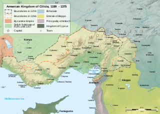
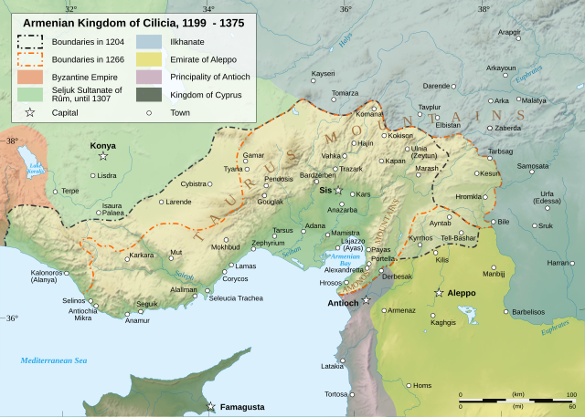
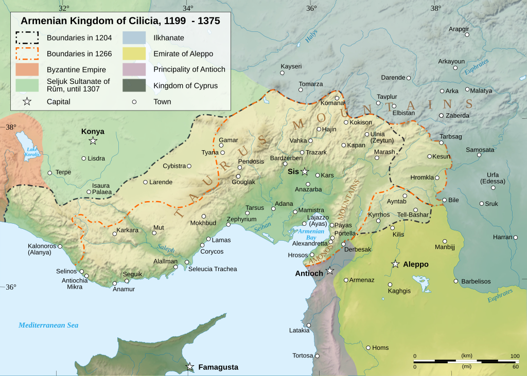
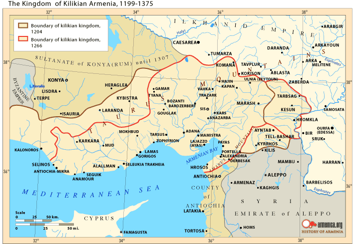
Čeština: Mapa Arménského království v Kilíkii v 13. století. Deutsch: Karte des Armenischen Königreichs von Kilikien während des 13. Jahrhunderts. English: Map of the Armenian Kingdom of Cilicia during the XIII century. Español: Mapa del siglo XIII del Reino armenio de Cilicia. Esperanto: Mapo de la Armena reĝlando en Kilikio dum la 13-a jarcento. Français : Carte en anglais du royaume de Petite Arménie (en Cilicie) au XIIIe siècle. Italiano: Mappa topografica del regno armeno di Cilicia durante il XIII secolo. Kapampangan: Metung a mapa ning Kaariang Armenian ning Cilicia aniang ka-XIII a dilanua o siglu. Magyar: A Kilikiai Örmény Királyság 13. századi állapotát mutató térkép. Nederlands: Engelstalige kaart van Cilicisch Armenië in de 13e eeuw. Polski: Mapa Armenii Małej w XIII wieku. Português: Mapa do Reino Armênio da Cilícia no século XIII. Svenska: En karta över det armeniska kungariket Kilikien under 1200-talet. Türkçe: 13. yüzyılda Kilikya Ermeni Krallığı'nın sınırları. Беларуская: Карта Кілійскага армянскага царства (13 ст.) Македонски: Карта на Ерменското кралство Киликија во XIII век. Հայերեն : Կիլիկիայի Հայկական Թագավորության քարտեզը 13րդ դարում. বাংলা : ত্রয়োদশ শতকের সিলিসিয়ার আর্মেনীয় রাজত্বের মানচিত্র। 한국어: 13세기 킬리키아 아르메니아 왕국의 지도 日本語: 13世紀のキリキア・アルメニア王国の地図。 中文(简体): 奇里乞亚亚美尼亚王国13世纪地图 中文(繁體): 奇里乞亞亞美尼亞王國13世紀地圖 العربية : خريطة لمملكة قيليقية الأرمينية خلال القرن الثالث عشر مازِرونی : نخشه پادشائی کلیسائ ارمنی قرن |
||||||||
| Data | |||||||||
| Font |
Treball propi. English: Sources :
Software used :
Other data :
Français : Sources :
Logiciels utilisés :
Autres données :
|
||||||||
| Creador | |||||||||
| Georeferencing | If inappropriate please set warp_status = skip to hide. | ||||||||
| Altres versions |
[]
| ||||||||
| Reconeixement (required by the license) | © Sémhur / Wikimedia Commons / | ||||||||
| Assessments |
|
||||||||
| SVG | Aquesta imatge vectorial ha estat creada amb Inkscape .
|
||||||||
| Graphic Lab |


| Posició de la càmera | | Aquesta i altres imatges properes a: OpenStreetMap |
|---|
Llicència[modifica]
Jo, el titular dels drets d'autor d'aquest treball, el public sota les següents llicències:
| Copyleft: Aquesta és una obra d'art lliure: Podeu redistribuir-la i modificar-la sota els termes de la Llicència d'Art Lliure. Trobareu una còpia d'aquesta llicència al web Copyleft Attitude, així com en altres llocs web. |
This file is licensed under the Creative Commons Attribution-Share Alike 4.0 International, 3.0 Unported, 2.5 Generic, 2.0 Generic and 1.0 Generic license.
- Sou lliure de:
- compartir – copiar, distribuir i comunicar públicament l'obra
- adaptar – fer-ne obres derivades
- Amb les condicions següents:
- reconeixement – Heu de donar la informació adequada sobre l'autor, proporcionar un enllaç a la llicència i indicar si s'han realitzat canvis. Podeu fer-ho amb qualsevol mitjà raonable, però de cap manera no suggereixi que l'autor us dóna suport o aprova l'ús que en feu.
- compartir igual – Si modifiqueu, transformeu, o generareu amb el material, haureu de distribuir les vostres contribucions sota una llicència similar o una de compatible com l'original
Podeu seleccionar la llicència que vulgueu.
Jo, el titular dels drets d'autor d'aquest treball, el public sota la següent llicència:

|
S'autoritza la còpia, la distribució i la modificació d'aquest document sota els termes de la llicència de documentació lliure GNU versió 1.2 o qualsevol altra versió posterior que publiqui la Free Software Foundation; sense seccions invariants, ni textos de portada, ni textos de contraportada. S'inclou una còpia d'aquesta llicència en la secció titulada GNU Free Documentation License. |
| Aquest fitxer està subjecte a la llicència de Creative Commons Reconeixement i Compartir Igual 3.0 No adaptada. | ||
| ||
| Aquest avís de llicència s'ha afegit a aquest fitxer d'acord amb l'actualització de la llicència GFDL. |
Historial del fitxer
Cliqueu una data/hora per veure el fitxer tal com era aleshores.
| Data/hora | Miniatura | Dimensions | Usuari/a | Comentari | |
|---|---|---|---|---|---|
| actual | 19:23, 9 març 2023 | | 2.508 × 1.789 (713 Ko) | Ömer faruk çakmak (discussió | contribucions) | File uploaded using svgtranslate tool (https://svgtranslate.toolforge.org/). Added translation for tr. |
| 18:29, 9 març 2023 |  | 2.508 × 1.789 (691 Ko) | Ömer faruk çakmak (discussió | contribucions) | File uploaded using svgtranslate tool (https://svgtranslate.toolforge.org/). Added translation for tr. | |
| 10:58, 17 gen 2008 |  | 2.508 × 1.789 (671 Ko) | Sémhur (discussió | contribucions) | Correcting few bugs (x2) | |
| 10:55, 17 gen 2008 |  | 2.508 × 1.789 (671 Ko) | Sémhur (discussió | contribucions) | Correcting few bugs | |
| 19:42, 16 gen 2008 |  | 2.508 × 1.789 (671 Ko) | Sémhur (discussió | contribucions) | heavier... Too bad | |
| 19:33, 16 gen 2008 |  | 2.508 × 1.789 (261 Ko) | Sémhur (discussió | contribucions) | bigger size, lighter weight, + coordinates | |
| 11:38, 13 gen 2008 |  | 1.458 × 991 (362 Ko) | Sémhur (discussió | contribucions) | == Description == {{Information |Description= {{en| Map of the Armenian Kingdom of Cilicia during the XIII century.}} {{fr| Carte en anglais du royaume de Petite Arménie (en Cilicie) au XIII<sup>ème</sup> siècle.}} |S |
No podeu sobreescriure aquest fitxer.
Ús del fitxer
Les 62 pàgines següents utilitzen aquest fitxer:
- Atlas of Armenia
- Atlas of Turkey
- Atlas of the Levant
- User:Magog the Ogre/Multilingual legend/2023 March 1-10
- User:Miya/POTY/Diagrams2008
- User:Notafish/Votes 2008
- User:Sémhur
- User talk:Sting/Archive 01
- Commons:Featured picture candidates/Image:Cilician Armenia-en.svg
- Commons:Featured picture candidates/Log/January 2008
- Commons:Featured pictures/Non-photographic media/Maps
- Commons:Featured pictures/chronological/2008-A
- Commons:Picture of the Year/2008/Galleries/All
- Commons:Picture of the Year/2008/Galleries/Diagrams
- Commons:Picture of the Year/2008/Results/Round 1/Gallery/All
- Commons:Picture of the Year/2008/Results/Round 1/Gallery/Diagrams
- Commons:Picture of the Year 2008/File:Cilician Armenia-en.svg
- Commons:Potd/2010-03 (da)
- Commons:Potd/2010-03 (de)
- Commons:Potd/2010-03 (nl)
- Commons:Potd/2010-03 (pt)
- File:Armenianmeds.gif
- File:Cilician Armenia-ar.svg
- File:Cilician Armenia-cs.svg
- File:Cilician Armenia-en.svg
- File:Cilician Armenia-fr.svg
- File:Cilician Armenia-hu.svg
- File:Cilician Armenia-it.svg
- File:Cilician Armenia-sv.svg
- Template:Other versions/Cilician Armenia
- Template:Potd/2010-03
- Template:Potd/2010-03-04
- Template:Potd/2010-03-04 (ar)
- Template:Potd/2010-03-04 (be)
- Template:Potd/2010-03-04 (bn)
- Template:Potd/2010-03-04 (ca)
- Template:Potd/2010-03-04 (cs)
- Template:Potd/2010-03-04 (da)
- Template:Potd/2010-03-04 (de)
- Template:Potd/2010-03-04 (en)
- Template:Potd/2010-03-04 (eo)
- Template:Potd/2010-03-04 (es)
- Template:Potd/2010-03-04 (fr)
- Template:Potd/2010-03-04 (hu)
- Template:Potd/2010-03-04 (hy)
- Template:Potd/2010-03-04 (it)
- Template:Potd/2010-03-04 (ja)
- Template:Potd/2010-03-04 (ko)
- Template:Potd/2010-03-04 (mk)
- Template:Potd/2010-03-04 (mzn)
- Template:Potd/2010-03-04 (nl)
- Template:Potd/2010-03-04 (pam)
- Template:Potd/2010-03-04 (pl)
- Template:Potd/2010-03-04 (pt)
- Template:Potd/2010-03-04 (ru)
- Template:Potd/2010-03-04 (sv)
- Template:Potd/2010-03-04 (uk)
- Template:Potd/2010-03-04 (zh-hans)
- Template:Potd/2010-03-04 (zh-hant)
- Template:Potd/2010-03 (zh-hans)
- Category:Armenian Kingdom of Cilicia
- Category:Armenian Kings of Cilicia
Ús global del fitxer
Utilització d'aquest fitxer en altres wikis:
- Utilització a als.wikipedia.org
- Utilització a an.wikipedia.org
- Utilització a arz.wikipedia.org
- Utilització a ast.wikipedia.org
- Utilització a azb.wikipedia.org
- Utilització a az.wikipedia.org
- Utilització a ba.wikipedia.org
- Utilització a be.wikipedia.org
- Utilització a bg.wikipedia.org
- Utilització a bn.wikipedia.org
- Utilització a ca.wikipedia.org
- Utilització a crh.wikipedia.org
- Utilització a cs.wikipedia.org
- Utilització a cv.wikipedia.org
- Utilització a de.wikipedia.org
- Utilització a el.wikipedia.org
- Utilització a en.wikipedia.org
- Cilicia
- History of Armenia
- List of monarchs of the Armenian Kingdom of Cilicia
- Hethum II
- Leo I, King of Armenia
- Rumkale
- Armenian Kingdom of Cilicia
- Toros Roslin
- Armenian illuminated manuscripts
- Armenia
- Portal:Maps/Maps/Political
- Portal:Maps/Maps/Political/12
- Second Battle of Sarvandik'ar
- Wikipedia:Wikipedia Signpost/2012-04-30/WikiProject report
- Wikipedia:Wikipedia Signpost/Single/2012-04-30
- Wikipedia:Featured picture candidates/May-2013
- Wikipedia:Featured picture candidates/Cilician Armenia
- User:Falcaorib
- History of Cilicia
- Talk:Armenia/Archive 9
- Zayn al-Din Qaraja
- Ghars al-Din Khalil
Vegeu més usos globals d'aquest fitxer.
Metadades
Categories:
- Maps of Cilicia
- Maps of the Armenian Kingdom of Cilicia
- SVG maps of the history of Armenia
- Maps of the history of Turkey
- Maps of the history of Syria
- Maps showing 12th-century history
- Maps showing 13th-century history
- Maps showing 14th-century history
- Topographic maps of the Middle East
- English-language SVG maps showing history