File:EasternRomanEmpire.png
Zur Navigation springen
Zur Suche springen
Es ist keine höhere Auflösung vorhanden.
EasternRomanEmpire.png (250 × 175 Pixel, Dateigröße: 7 KB, MIME-Typ: image/png)
Bildtexte
Kurzbeschreibungen
Ergänze eine einzeilige Erklärung, was diese Datei darstellt.

|
This map has been uploaded by Electionworld from en.wikipedia.org to enable the |

|
Der Urheberrechtsinhaber erlaubt es jedem, dieses Werk für jeglichen Zweck, inklusive uneingeschränkter Weiterveröffentlichung, kommerziellem Gebrauch und Modifizierung, zu nutzen. |
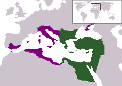
The territory in green represents the core areas held by the Eastern Roman Empire before the Muslim conquests The territory in purple represents the greatest extent of the Byzantine Empire under Emperor Justinian I
Dateiversionen
Klicke auf einen Zeitpunkt, um diese Version zu laden.
| Version vom | Vorschaubild | Maße | Benutzer | Kommentar | |
|---|---|---|---|---|---|
| aktuell | 18:27, 13. Dez. 2006 | | 250 × 175 (7 KB) | Electionworld (Diskussion | Beiträge) | {{ew|en|24630}} {{CopyrightedFreeUse-User|24630}} The territory in green represents the core areas held by the Eastern Roman Empire before the Muslim conquests The territory in purple represents the greatest extent of the Byzantine Empire unde |
Du kannst diese Datei nicht überschreiben.
Dateiverwendung
Die folgenden 25 Seiten verwenden diese Datei:
- Atlas of Albania
- Atlas of Armenia
- Atlas of Bosnia and Herzegovina
- Atlas of Croatia
- Atlas of Cyprus
- Atlas of Egypt
- Atlas of Greece
- Atlas of Israel
- Atlas of Italy
- Atlas of Jordan
- Atlas of Kosovo
- Atlas of Lebanon
- Atlas of Libya
- Atlas of Malta
- Atlas of Montenegro
- Atlas of North Macedonia
- Atlas of Northern Cyprus
- Atlas of Palestine
- Atlas of Serbia
- Atlas of Syria
- Atlas of Tunisia
- Atlas of Turkey
- Atlas of ancient Rome
- Atlas of the Byzantine Empire
- User:とある白い猫/List/Sources/04
Globale Dateiverwendung
Die nachfolgenden anderen Wikis verwenden diese Datei:
- Verwendung auf da.wikipedia.org
- Verwendung auf en.wiktionary.org
- Verwendung auf gd.wikipedia.org
- Verwendung auf lv.wikipedia.org
- Verwendung auf no.wikipedia.org
- Verwendung auf ru.wiktionary.org
- Verwendung auf sl.wikipedia.org
- Verwendung auf sq.wikipedia.org
- Verwendung auf sv.wikipedia.org
- Verwendung auf vi.wikipedia.org
- Verwendung auf zh.wiktionary.org